Norway
Itinerary: Oslo – Bergen – Folgefonna Nasjonalpark – Southwestern fjords – Western fjords – Aurlandsfjellet – Sognefjellet – Geiranger – Trollstigen – Atlanterhavsveien – Ålesund – Jostedalsbreen Nasjonalpark
I only realized how big Norway is when I took a good look at a map. There is no less than 2,518 kilometers between the southern coast of Norway and the North Cape, all the way to the north. The country extends north of Sweden and Finland and borders Russia there. During this trip I will visit the southern and western part of Norway.
During the last ice age, what is now Norway was covered by a layer of ice two kilometers thick. Huge glaciers carved valleys that filled with water due to rising sea levels, forming the fjords that characterize western Norway. Today, Norway has about 5.5 million inhabitants and is one of the least populated countries in Europe.
Although a European country, Norway is not a member of the European Union. The Norwegians value their independence, and that has everything to do with the past. Norway has only been an independent country since 1905. From the late fourteenth to the early nineteenth century, Norway was part of the united kingdom of Denmark, Sweden and Norway (led by Denmark) and in 1814, the united kingdom of Norway and Sweden was formed, effectively bringing Norway under Swedish rule.
When Norway became an independent country in 1905, it was one of the poorest countries in Europe. That changed radically when oil was found in the Norwegian part of the North Sea in 1969. The oil yield has turned Norway from one of the poorest countries in Europe into one of the richest, with a high standard of living. It is therefore not a cheap travel destination, however, a very beautiful one.
Oslo
My flight from Amsterdam to Oslo leaves with a delay of 45 minutes. It’s only an hour and a half flight and just after 11 p.m. we land at Gardermoen International Airport, fifty kilometers north of the Norwegian capital. The comfortable Airport Express Train runs from the airport to Oslo Sentralstasjon in twenty minutes. The next morning it turns out te be sunny weather, perfect to explore the city, something I’ve planned two days for.
The Norwegian capital is located in the southeast of the country, with hills, forests and lakes to the north of the city and the waters of the Oslofjord to the south. The city was founded at the end of the eleventh century and in the thirteenth century, King Håkon had a fortress built, Akershus Festning, to protect the city from invaders. After the city burned to the ground in the sixteenth century, the then king Christian IV had the city rebuilt and took the opportunity to give the city a new name: Christiania. After the independence of Norway, Christiania became the capital of the new kingdom and in 1925 the city got back its old name: Oslo.

Today, Oslo has about 635,000 inhabitants. The city center is compact and most of it can be easily reached on foot. I start my visit to Oslo at the Nasjonalmuseet, the national museum that moved to a brand new and sleek building by the harbor in 2022, in what is called the new museum quarter of the city. The beautiful building houses an impressive collection of both Norwegian and European ancient and modern art. The highlight are the works of the existentialist painter Edvard Munch (known for ‘The Scream’), but the paintings of Norwegian landscapes are also impressive.
The new Nasjonalmuseet is next to an older building, which houses the Nobels Fredssenter. Every year the Nobel Peace Prize is awarded in Oslo’s city hall, the Rådhus (the Fredssenter is a museum about the history of this prize). The red-brown Rådhus is a stone’s throw from the Fredssenter, on the Rådhusplassen, with its back to the harbor. Inaugurated in 1950, the building has two rectangular towers and is surrounded by statues and plaques that depict the history of cultural and working life in Norway. The colonnades at the front have carved panels depicting scenes from Norse mythology.
On the other side of the Rådhusplassen are the quays from which ferries depart for the Bydøy peninsula and tours of the Oslofjord. I stay on shore though and stroll along the Aker Brygge promenade, where you will find plenty of restaurants and terraces, plus a marina and waterfront views of (and islands in) the Oslofjord. A little north of the Rådhus is an elongated park, with the Nationaltheatret (national theatre) on one side and the Stortinget, Norway’s parliament building, built in 1866, on the other. In between is a park with trees, benches, a pond with a fountain and – in spring – many blooming flowers. The stately Grand Hotel is also located at the park.
On my second day in Oslo it’s beautiful sunny spring weather again. After starting my day with coffee (the Norwegians are true coffee lovers), I first head to one of the most iconic buildings of contemporary Oslo: the Operahuset, built in 2008. This modern opera house is located on the waterfront of the Oslofjord and its white marble and glass design is inspired by floating ice floes. The roof of the building slopes upwards around the central part of the building. The white marble stands out sharply against the blue sky and on top of the roof you have a wide view over the city and the water.
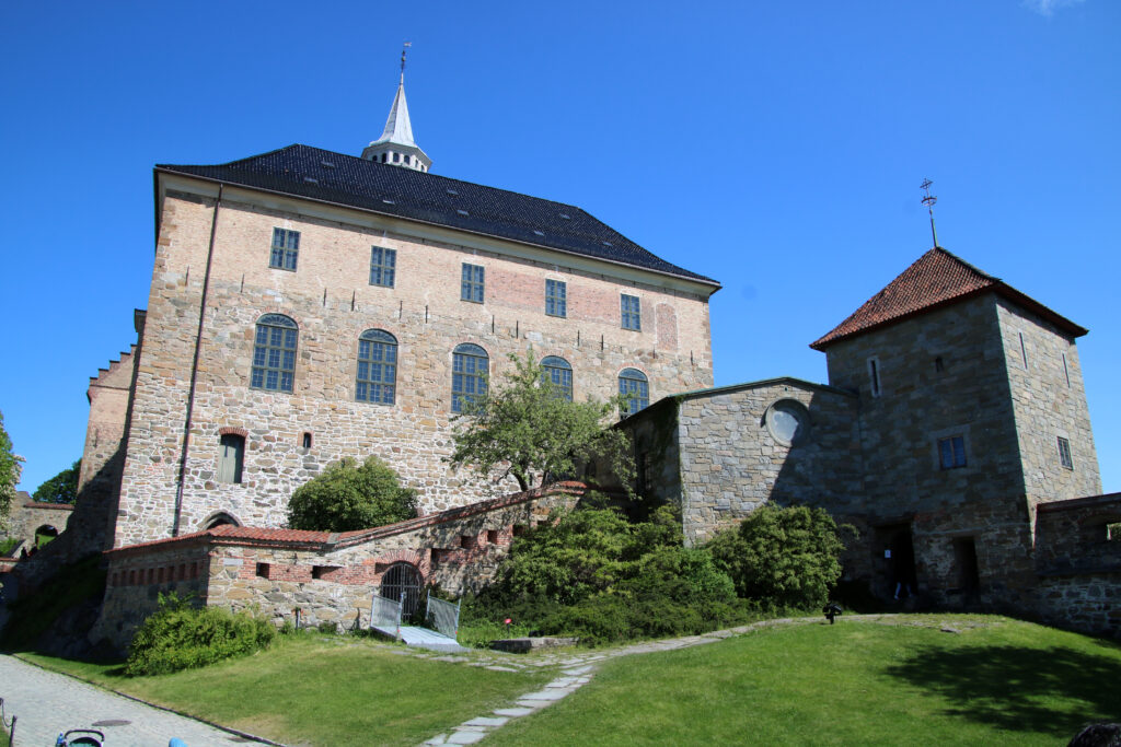
Next I walk to Akershus Festning, the fortress built in 1299 by order of King Håkon V to protect the then brand new capital against attackers. Within the fortress walls are several buildings, including the medieval castle Akershus Slott.
In the afternoon I walk down the Karl Johans Gate towards the royal palace, Det Kongelige Slott. The construction of the pastel yellow palace started in 1825, but it was not until 1905 that the king of Norway, which had become independent in that year, would take up residence there. It’s striking that the palace is not on an enclosed area with a large fence around it, despite the fact that the current king and his family live in the palace. The palace is surrounded by the Slottsparken, a green park with ponds, benches and lawns, a wonderful place to relax for a few hours on a beautiful Sunday afternoon like this.
In my opinion, Oslo is a very nice city, with beautiful architecture, interesting museums, green parks, many coffee shops and restaurants, friendly people and a relaxed atmosphere. A good destination for a city trip, or – as in my case – as a starting point for a road trip through Norway.
Bergen
After two days it’s time to leave Oslo. The train leaves Oslo Sentralstasjon just before 8:30 a.m. for the 6.5-hour ride to Bergen, all the way on the west coast of the country. Once the train has left Oslo behind, the scenery looks like what you imagine when you think of Norway: hills, forests, lakes, wooden houses and farms dotted all over the landscape. The train’s route goes right through the interior of Norway, across the Hardangervidda Plateau. The highest point is about halfway, at 1,200 meters above sea level. At this altitude the lakes are frozen and there is snow, lots of snow. What a difference with sunny Oslo…
The next morning it’s cloudy, but dry. I start the day in the art museum of Bergen: KODE. This museum has several collections, spread over four buildings. I limit myself to KODE 3, with works by Edvard Munch and other Norwegian painters. Then I walk to Vågen, the old port of Bergen. Here is the Torget fish market, where you can buy fresh fish and shellfish daily and eat on site as well.

On the east side of Vågen is the historic district of Bryggen. In the twelfth and thirteenth centuries, Bryggen (now Bergen) was the capital of Norway for some time. As a member of the Hanseatic League (an association of cities in Germany, the Netherlands and the Scandinavian countries), it was the most important and largest city in the country and would remain so until the end of the nineteenth century. The colored merchant houses and warehouses on the quay still remind us of this time and are now on the Unesco World Heritage List.
About sixty wooden houses have been preserved. They date from after the fire of 1702 that destroyed Bryggen, and some have been rebuilt after another fire in 1955. Between the buildings, some of which are being restored, narrow alleys lead to the buildings behind. Most of them are three storeys high and, in addition to being a house, also served as a warehouse, which can still be seen from the pulley on the facade.

On the east side of the center of Bergen is the four hundred meter high mountain Fløyen. Wooden houses are built against the mountainside and narrow streets zigzag up. You can take a funicular to the top of Fløyen, but it’s more fun to walk into a random street from the city center and see where you end up. The wooden houses and steep streets are very photogenic. From the viewpoint at the Skansen Battalion, an old fire station (which looks a bit like an old church) you have a panoramic view over Bergen and the harbor. I climb a bit further, along the Tippetue trail and if you want you can go even further up, all the way to the top of Fløyen.
By the end of the afternoon I return to the Torget fish market, because where better to eat fresh fish? When I travel, I like to try local specialties, so I decide to eat something you can eat in only three countries in the world (Norway, Iceland and Japan): whale. In Norway, this means minke whale, a whale species that is not threatened with extinction. The whale steak is delicious. It’s not fishy (since whales are mammals, not fish), the dark meat most closely resembles venison steak.
Folgefonna National Park
After the cities of Oslo and Bergen, my road trip through (western) Norway starts. First I pick up my rental car (to do so, I have to go to the other side of the city). In the familiar surroundings of a Ford Focus (the same car I drive at home) I drive out of town. First to the south, then to the east. Outside the weather is cloudy and drizzly.
It immediately becomes clear to me how mountainous Norway is. The road meanders between the mountains and regularly underneath them. Back in the days you had to drive all around the mountains, but in recent decades the Norwegians have drastically shortened the distances by building tunnels everywhere. I don’t know how many tunnels I drive through on my first day on the road alone, I quickly lose count.

I also notice that some roads are not overly wide. Only around the cities you will find four-lane roads, in the rest of Norway you drive on two- and one-lane roads. Some are so narrow that two cars (let alone campers or busses) can barely pass each other and when two trucks meet, one has to back up to let the other one pass. The maximum speed is eighty kilometers per hour, and often lower near built-up areas.
If you travel around western Norway, you cannot avoid taking a ferry every now and then. The fjords run so deep into the country, often with multiple branches, that detouring is impossible. That’s why you will find ferry services everywhere and I’m making my first crossing today, across the waters of the Hardangerfjord.
My destination is Folgefonna Nasjonalpark. At the heart of this 545 square kilometer national park lies the Folgefonna Ice Sheet, with 168 square kilometers in size the third largest ice sheet in Norway. The surrounding mountains and many valleys are also part of the national park. Bondhusdalen is located on the west side of the huge ice cap. Here I take a nice two hour walk (out and back) along the Bondhus river. It’s cloudy, but dry and perfect weather for a walk. At the end you will reach the highlight of the walk: Bondhusvatnet, or Bondus Lake. The view over the lake is beautiful, with mountains all around that reflect in the water. When the clouds clear for a while, you can see the Bondhus Glacier (Bondhusbreen) on the other side of the lake, one of the many glaciers of the Folgefonna Ice Sheet. Although most of the ice in Norway disappeared after the last Ice Age, the country still has over 2,500 glaciers today. Many of these have shrunk considerably in the twentieth century due to global warming.

After walking back, I continue towards the village of Odda. On this stretch I pass through the longest tunnel so far: the Folgefon tunnel is no less than eleven (!) kilometers long. Half an hour south of Odda is the Langfoss waterfall (foss meaning waterfall in Norwegian). The Langfoss is six hundred meters high, making it the fourth highest waterfall in Norway. Langfoss is not the only waterfall I see along the road south of Odda. I pass Vidfoss and Espelandsfoss and what I personally find the most spectacular one: the double waterfall Låttefoss. The surroundings are beautiful; mountains, lakes, waterfalls, especially when the sun breaks through, it is beautiful out here.
The next day, Thursday, I get up early and at a quarter to eight I start my hike to the Buarbreen Glacier. This is also one of the glaciers of the Folgefonna ice cap. In contrast to the easy walk yesterday, this is a somewhat tougher climb. The marked trail runs through the Buardalen valley and up the mountainside, mostly through the trees, with the constant murmur of the Buarelvi River in the background. The Buardalen is surrounded by high mountains and the highest parts of them still have snow. After more than an hour of walking I arrive at the viewpoint, where you can see the Buarbreen Glacier. Or what’s left of it, because like many other glaciers this one ran much further down the mountainside into the valley until a century ago. Nevertheless, it is a nice place and because I started walking early, there is no one else there.
The southwestern and western fjords
After my walk I drive back to Odda and from there I head north. The road follows the coastline of the Sørfjord, a branch of the Hardangerfjord. The road is quite narrow, in some places two cars can just pass each other (and sometimes not even). On the left are occasional spots where you can stop for a beautiful view of the water and the mountains on the other side. It’s beautiful sunny weather again, so really a very enjoyable piece of road trip.

I also stop in the village of Lofthus, beautifully situated on the fjord, with wooden houses and fruit orchards against a backdrop of mountains. The village of Eidfjord is located at the end of the fjord that bears the same name, surrounded by high mountains. A huge cruise ship is docked at the quay. I drive a little further, to the border of the Hardangervidda plateau. Here is the 182 meter high Føringsfoss. There are actually several waterfalls here, but the Føringsfoss itself is the most beautiful one, a narrow, high waterfall that falls from a cliff into a deep gorge. The sun shining on the water spray creates a beautiful rainbow.
And then about the tunnels… in Norway they have elevated building tunnels to an art. Just before Eidfjord in the Butunnel I arrive at a roundabout. Yes, a roundabout in a tunnel! Is it one tunnel or are there three that converge here? Either way, I can go in different directions. And on the way to the Føringsfoss I first pass through the Mabøtunnel, which makes a kind of loop, and then through the Storegjeltunnel and Dalbergtunnel, which are shaped like a spaghetti that has accidentally fallen on the floor. Anything but straight and disorienting. Really bizarre tunnels.
After spending the night outside Eidfjord (the village), I drive back a bit, along the Eidfjord (the fjord), and in the tunnel with the roundabout I take a turn, which takes me straight to the Hardanger Bridge. What is special about this bridge, which opened in 2013, is that it is the longest tunnel-to-tunnel bridge in the world. From the tunnel you drive onto the bridge and on the other side of the bridge you immediately enter another tunnel. You almost forget that in between you are crossing the Hardangerfjord. 🙂
I drive through the village of Ulvik, which is located at the very tip of the Hardangerfjord. There is not much to see, except for the beautiful view of the fjord and the surrounding mountains. The village is an oasis of peace. After Ulvik I leave the southwestern fjords behind and head north. I pass the Oppheimvatnet (vatnet means lake in Norwegian), where the mountains are reflected in the water (it’s beautiful sunny weather again). I stop briefly at the hamlet of Stalheim, which was a stopping point for the mail route between Oslo and Bergen from the seventeenth to the nineteenth century, when mail was still transported by horse. Stalheim is located between the mountains, with a beautiful view over the valley below.

I am now in the area of the west fjords. Its southernmost extension is the Nærøyfjord. The Nærøyfjord, a UNESCO World Heritage Site, is an offshoot of the Sognefjord, the second longest fjord in the world (203 kilometers long). At the hamlet of Gudvangen, at the end of the Nærøyfjord, you have a wonderful view over the narrow fjord, which is surrounded on both sides by steep mountains that rise up to 1,200 meters. A beautiful place. High above the Nærøyfjord, the waterfall Kjelsfoss falls from the top of a mountain. You have to look up to see it or you’ll probably miss it. It’s a beautiful picture, with the falling water sparkling in the sun.
From the Nærøyfjord it is only a short distance – of course partly through tunnels (the eleven kilometer long Gudvanga tunnel and the five kilometer long Flenja tunnel) – to the village of Flåm. Flåm turns out to be an extremely touristic village, where people come for two reasons : to ride a touristy train to 864 meters higher Myrdal (where I passed on the train ride from Oslo to Bergen) or because they are passengers of a cruise ship that sails through the Norwegian fjords and anchors in Flåm. I quickly leave the place. Mid-afternoon I arrive in the village of Aurland (or Aurlandsvangen), located at the end of the Aurlandsfjord.
Aurlandsfjellet and Sognefjellet
It is still early in the summer season, but there are already quite a few holidaymakers in Norway at the end of May, the beginning of June. I don’t want to think about how busy it must be here during the peak season in July or August… And although it’s not midsummer yet, I do notice that it doesn’t get really dark at night. The sun does not stay above the horizon like during the midnight sun above the Arctic Circle, but still: it doesn’t get really dark. Even at two or three a.m. it’s still light outside.
If you want to go from Aurland to Lærdal you can drive through the Lærdal tunnel. This tunnel is an impressive 24.5 (!) kilometers long, making it the longest land tunnel in the world. If you think it’s cool to drive through a 24.5 kilometer long tunnel, please do so, but from June to September there is a more attractive alternative: the Aurlandsfjellet. This is the 47-kilometer scenic route across the high, desolate plateau that separates Aurland from Lærdal (and underneath which the Læerdal tunnel runs). From October to May, the Aurlandsfjellet is closed because snow makes the road impassable. Even in the summer there is snow on the side of the road, in many places more than a meter high, hence the Norwegian nickname: Snøvegen.

From Aurland the narrow road climbs up through a number of sharp hairpin bends. After eight kilometers you will find the Stegastein viewpoint. The wooden viewpoint, built in 2016, rises high above the Aurlandsfjord. The view over the fjord is beautiful. And if you go early, there’s hardly anyone there. The Aurlandsfjellet is one of the Norwegian Nasjonale Turistveger. The highest point is 1,300 meters above sea level. The landscape is barren, but the mountains in combination with the snow make it a beautiful surrounding. Very worthwhile and undoubtedly much more beautiful than the tunnel…
After the Aurlandsfjellet I take the ferry across the Aurlandsfjord and drive a bit north, to the village of Solvorn. Solvorn is located on the Lustrafjord, the northern extension of the large Sognefjord. It’s a small, sleepy village, with cute wooden houses, beautifully situated on the edge of the fjord.

The next day (Sunday) a ride of 220 kilometers is on the menu. I first drive along the water, until the end of the Lustrafjord. Route 55, better known as the Nasjonale Turistveger Sognefjellet, starts here. This 108 kilometer long road runs through Jotunheimen Nasjonalpark and is also called ‘the road over the roof of Norway’. The (in many places quite narrow) road goes up via a number of sharp hairpin bends and soon I find myself above the tree line. The peaks of the Skagastølstindane loom up and the surroundings turn white again. The snow stands out beautifully against the clear blue sky. This Nasjonale Turistveger is also only accessible in summer, just like the Aurlandsfjellet. The highest point of the Sognefjellet is slightly higher: 1,434 meters above sea level. There are many places where you can stop to enjoy the spectacular view.
On the other side the road descends into Bøverdalen. At Fossbergom I turn left onto route 15. The road goes through an elongated valley, past farms and small villages, until it starts to rise again at the hamlet of Grotli. This is the Strynefjellet, also a Nasjonale Turistveger. Again I find myself in a snowy and mountainous landscape. I drive past the still frozen Beidalsvatnet, and then follow the sign to Geiranger.
Geirangerfjord and Trollstigen
Route 63 winds along the mountain slopes, now below the tree line again and therefore through a green surrounding, with a beautiful view over the Breidalen. Up a series of hairpin bends I arrive at the Flydalsjuvet viewpoint. From this point you have a fantastic view over perhaps the most famous fjord in the world: the mighty Geirangerfjord. This fjord is also on the Unesco World Heritage List and is sandwiched between high mountains with snow-capped peaks. Waterfalls pour down from the mountainsides, it’s a postcard perfect picture.

The next morning the Geirangerfjord is covered with a thick layer of gray clouds that obscure the tops of the mountains surrounding the fjord. I guess this makes the view from the Ørnesvingen viewpoint slightly less beautiful than it would be on a clear day. I continue my journey north, taking the ferry across the Norddalsfjord, and driving through the elongated Valldalen valley. You can clearly see from the typical U-shape that the valley has been carved out by a glacier.
When the road starts to rise again, the area turns white again due to the snow. Because there is also a dense fog, the white of the snow flows over into the white of the fog, in other words: there’s almost nothing to see. At the top of the pass is the Trollstigen viewpoint. Trollstigen (troll staircase) is the name of one of the most famous stretches of road in Norway. Here route 63 runs up (or down, if you look from above) the mountainside via eleven hairpin bends and a gradient of more than ten percent. From the vantage point you can see the road including all hairpin bends – that is, if it’s not foggy. The road should be there, but I don’t see anything… This changes as I drive down the Trollstigen and come below fog and clouds. The road opened in 1936 (it took eight years to build) and runs sharply downwards, past waterfalls and, as said, eleven hairpin bends. If the mountains are not shrouded in fog and clouds, it is surely more impressive than the day I visit.
After Trollstigen I drive straight to Kristiansund, a three-hour drive north. The road winds through green valleys, between mountains, along the Romsdalfjord, the Langfjord and the Tingvollfjord, past villages and farms, over the Gjemnessund bridge and through the five kilometer long Freifjord tunnel. By the end of the afternoon I arrive in Kristiansund, the first city of any size since I left Bergen. Kristiansund is the northernmost point of my road trip and base for Atlanterhavsveien, or Atlantic Ocean Road, which I visit the next day.
Atlanterhavsveien and Ålesund
The Atlanterhavsveien is an eight kilometer long road that connects seventeen islands along the Norwegian Atlantic coast. Of all the bridges between the islands, the Storseisund Bridge is the largest and most famous. This is also a Nasjonale Turistveger, and although it is a nice route, I think it is a bit overhyped. Maybe because it’s only five miles, but it probably doesn’t help that it’s cloudy, windy and rainy when I drive down the Atlanterhavsveien either.
After the Atlanterhavsveien I drive to Molde, where I take the ferry to the other side of the Romsdalfjord, and from there I continue to Ålesund. Like Kristiansund, Ålesund is also a port city, located almost directly on the Atlantic Ocean. In 1904, a large part of the wooden buildings of Ålesund burned down and the destroyed part of the city was rebuilt in the then popular Jugendstil or Art Nouveau.

At the quay in Ålesund, home to a large fishing fleet, two huge cruise ships are moored. The passengers have spread out over the town, which seems rather touristy to me. The backstreets, on the other hand, are remarkably quiet, a bit dead even, and give the impression of faded glory. Only the small center of the town, on both sides of the inner harbor of Brosundet, is lively. Especially with cruise tourists.
After two hours I have seen enough of Ålesund. I drive to Solavågen, where I cross the Storfjord by ferry. The road follows the Storfjord and then runs along the Ørstafjord. Now that I’m a bit further south and further from the Atlantic coast, the weather is also significantly better. Here the sun shines again. The Voldsfjord and the Austefjord are both relatively short fjords, especially compared to the Nordfjord, which I pass a little later. The Nordfjord is 106 kilometers long, making it one of the longest fjords in Norway. At the end of this fjord loom the snowy peaks of Jostedalsbreen Nasjonalpark.
Jostedalsbreen National Park
Norway’s Jostedalsbreen is the largest ice sheet in mainland Europe. It covers about 487 square kilometers and is said to be up to 600 meters thick (try to imagine: a layer of ice 600 meters thick!). The area is a protected nature reserve and is part of the Jostedalsbreen Nasjonalpark.
I spend the night near the town of Olden, on the north side of Jostedalsbreen, and on Wednesday morning I drive into the Oldendalen valley. The narrow road winds through the green valley, and at the end of the valley, a path leads up to the Briksdals Glacier (Briksdalsbreen). The place is teeming with tourists, so it is anything but quiet. The walk to the glacier is five kilometers (out and back) and brings you to a large glacial lake, surrounded by high mountains and of course the Briksdalsbreen. Or what’s left of it, because the glacier only extends a short distance over the edge of the mountain top, while two millennia ago it still reached far into the valley.

After driving back Oldendalen, I turn left. I drive along the Innvikfjord to Utvik. There the road goes up through a few hairpin bends. At the Ksjørbakkane viewpoint you have a beautiful panoramic view over the Innvikfjord. The route continues over the mountain pass Utvikfjellet, past the villages of Byrkjelo and Årdal, through a long valley. At Skei I turn left, drive along the Kjøsnesfjord, and after driving through the eleven-kilometre-long Kjøsnes tunnel and the six-kilometre-long Fjærlands tunnel, I am at the southern end of Jostedalsbreen Nasjonalpark.
Here is the Boyabreen or Boya Glacier. This glacier is also high on the edge of a mountain top, with the glacial lake at the bottom of the steep cliff. I personally find the location even more beautiful than that of the Briksdalsbreen: you are in the middle of a beautiful valley where you look up at the high massive granite walls of the surrounding mountains.

I also make a short stop at the Fjærlandsfjord, a branch of the large Sognefjord, before I drive to Førde, my last overnight stop of this trip. On Thursday it’s time to go home. I drive south from Førde, by ferry across the Sognefjord, along the Osterfjord towards Bergen. At the airport I return my rental car and at the end of the afternoon I fly back home.
During my two weeks in Norway I only saw part of the country, but what I saw is truly beautiful. A unique and beautiful landscape of mountains and water, which offers endless beautiful routes for road tripping.