Portugal
Itinerary: Porto – the Douro Valley – Aveiro – Coimbra – Batalha – Óbidos – Elvas – Monsaraz – Évora – Algarve – Lisbon
The former world power Portugal, located on the western side of the Iberian Peninsula, between Spain and the Atlantic Ocean, has been an independent country since the twelfth century. This makes it one of the oldest surviving nation states in Europe. It is also one of the youngest democracies in Europe: The first free elections under a democratic constitution were only held in Portugal in 1976. In the intervening centuries, Portugal played an important role on the world stage. The Portuguese were the first to circumnavigate Cape Horn and called it Cabo da Boa Esperança, Cape of Good Hope. In 1498, the Portuguese explorer Vasco da Gama was the first to circumnavigate Africa to India.
At the beginning of the sixteenth century, Portugal was a world power, with colonies in all directions: Not only the nearby Azores and Madeira, but also Brazil, India and Macau belonged to the Portuguese Empire. During this period, the Portuguese are an important player in the worldwide trade in, among other things, silver, spices, tobacco, sugar and cotton. The Portuguese also play a major role in the slave trade. In the nineteenth century, the Portuguese empire came to an end, and so did the wealth that it brought with it. Today, Portugal is one of the least prosperous countries in the European Union. But also a popular holiday destination and a well-known wine and port-making country.
Porto
I start my tour of Portugal in Porto, located at the mouth of the Douro River. The history of Porto (the country’s second-largest city after Lisbon) dates back to the Roman Empire and its riverside district, Ribeira, is a UNESCO World Heritage Site, but Porto is anything but an open-air museum. It’s a busy port city, which has been refurbished in recent years and where many old buildings have been renovated.
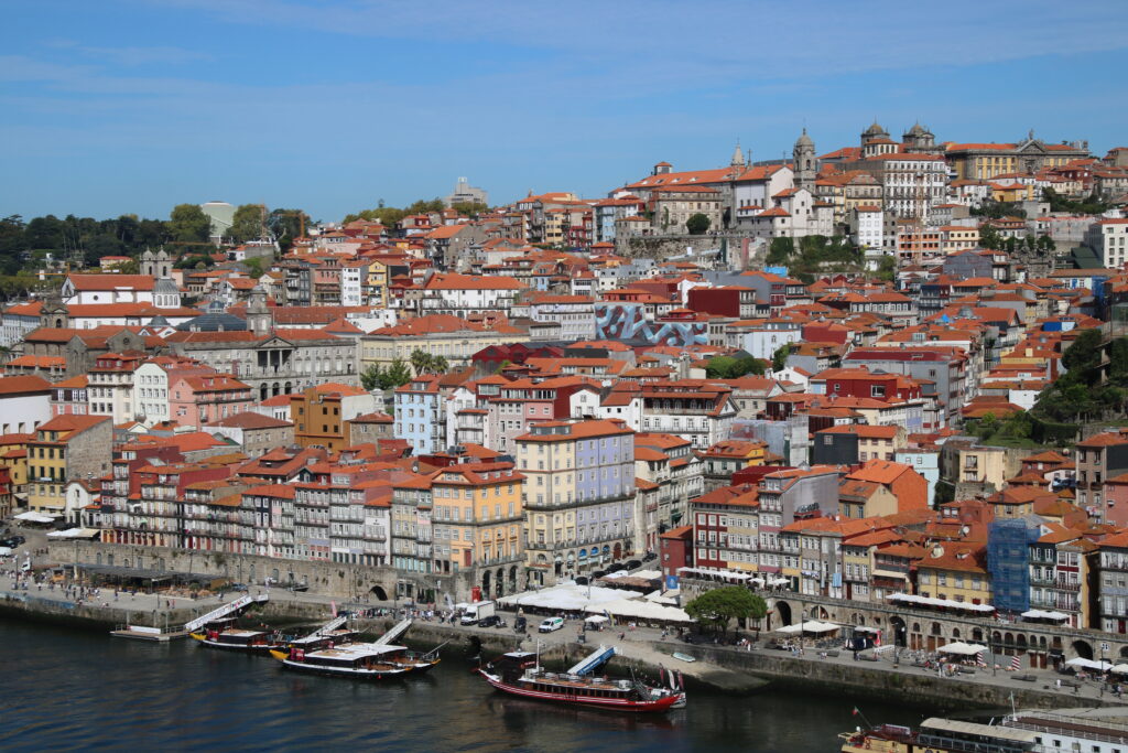
The city is built on the hills on the river bank. From Ribeira, the streets and buildings rise sharply. Some streets and alleys have stairs and from some higher places, such as the Miradouro da Vitória, you have a beautiful view. The Sé, the cathedral of Porto, built in the twelfth century, is also located on a high spot. From the square in front of the cathedral you have a beautiful view of the city. The streetscape in the old center of Porto is made up of narrow, high houses, often with five or six floors, cast iron balconies and tiled facades. A very typical architectural style and there are relatively few modern buildings in the center, so that the historic street remain very scenic (if you forget the cars for a while).
On the square Largo Amor de Perdição is a former prison, the Cadeia da Relação. It is now a freely accessible photography museum. I like photo exhibitions, but the building itself, where the thick bars are still on the windows, is also worth a look. A little further on is the Torre dos Clérigos, a 75 meter high tower from 1763, next to a church of the same name. From here it is not far to Estação de São Bento train station. This famous station has an imposing facade, but an even more beautiful hall, with large panels of blue and white so-called ‘azulejos’. Those azulejos, for which Portugal is known, are painted tiles that you see everywhere on the facades and in the interiors of houses, churches and other buildings. The art of painting tiles was introduced to Portugal in the eighth century by the Moors and is based on painting in the Arab world.

From the Palacio de Bolsa, the old stock exchange building, it’s just a short walk to Ribera, the riverside neighbourhood. The quays that once housed warehouses are now a pedestrian boulevard with restaurants, cafes and terraces. Above the quay are old houses with cast iron balconies and behind them are narrow cobbled streets. In the morning it is still quite quiet, later in the day it’s teeming with tourists. From the Cais da Ribeira you look out over the Douro and the port houses on the other side, in Vila Nova de Gaia. Unmissable is the Ponte Dom Luis I, the huge steel arch bridge that connects Porto to Vila Nova de Gaia. It is a double deck bridge; the lower level is for cars and pedestrians and the upper level, sixty meters above the water, is for the metro and also for pedestrians. From the bridge the view over the Douro and Ribeira is fantastic.
Vila Nova de Gaia was once an independent village, but is now part of Porto. You will find many port houses here, where you can do tours and tastings. It’s quite touristy; along the boulevard, in addition to old Port houses, there are also many restaurants, a cable car silently whizzes past you and advertising for the Port brands is abundant, just like the number of tourists. In addition to tour boats, there are also so-called ‘barcos rabelos’ in the water, traditional boats that used to transport barrels of port. And of course you have a fantastic view of Ribeira on the other side.
On the north side of the old center is the Avenida dos Aliados, a wide boulevard, with the Cámara Municipal, the city hall of Porto, on the north side. Aliados, as the boulevard is called in everyday language, has a very different atmosphere than the historic city around the Ribeira. More grandeur, less atmosphere. Porto’s most famous bookshop is the Livraria Lello, which is housed in an Art Deco building and whose interior is also said to be very beautiful. But, to enter you have to book online, pay five euros (mind you: to enter a bookstore) and on the Sunday morning that I walk by, there is a huge queue. I estimate the waiting time at least an hour. Big business for the bookshop and a real tourist trap if you ask me. I skipped it.

Because you really can’t have been to Porto without visiting a port house, on my last day in Porto I walk to Cave Cálem in Vila Nova de Gaia. They have been making port here since 1859. The grapes are grown on the hills in the Douro Valley and the port is then aged in large oak barrels in the cellars in Vila Nova de Gaia. Vinho de Porto, simply port, is the wine provided from the Douro region. Since 1756, only port produced here can be called that. Port differs from regular wine by adding alcohol, which stops the fermentation process, after which a long maturation process follows. The result is a sweet wine with a high alcohol percentage. At the end of the tour we get to taste two port wines, a white dry and a tawney that has aged for seven years. I’m not a big fan of port, but I really like the two from Cálem.
The Douro Valley
The Douro River flows from the Portuguese-Spanish border to the Atlantic Ocean. The Douro Valley, a wine region where grapes are grown for both ‘regular’ wine and port, is easy to visit from Porto. you can do this with an organized tour, with your own transport, but also by train. For since 1887, the Linha do Douro railway has been running along the north bank of the Douro river.

The first part of the train ride from Porto is not that special, the second half is a lot nicer – and slower. From the village of Mosteiro, the train closely follows the river, along the hills, through tunnels and over bridges. Every now and then we stop at a small station. On either side of the river on the hills are terraces with vineyards and olive trees. The slopes rise steeply, hence the narrow terraces. The soil consists mainly of rock, with only a thin fertile top layer that retains little moisture. In the summer it is hot and dry here, resulting in small, sweet, grapes with a concentrated taste.
The small village of Pinhão is the heart of the Douro wine region. Pinhão has a small station building with beautiful panels of blue and white azulejos, painted with images of the viticulture in and around Pinhão. In Pinhão I visit Quinta do Bomfim, a winery of the British-origin Symington family (the British started producing port, which is why most port brands have an English name). A small museum tells the history of the family business and I get to take a look at the vineyard myself. It is harvest season and people are working everywhere to harvest the grapes.

After visiting Quinta do Bonfim I go on a boat trip on the Douro. In an hour we sail along the hills with vineyards. Then I take the train back to Porto. The beautiful ride with the Linha do Douro is well worth it. It takes 2.5 hours (one way), but the train ride is part of the trip to the Douro Valley.
Aveiro
After four nights in Porto I take the train to Aveiro. Normally that would be a journey of one and a half hours, but the trains in Portugal do not run exactly on time and due to construction work along the track, the train also runs slowly the first part. Luckily I’m in no rush… Aveiro has been called the ‘Venice of Portugal’, which I find rather pretentious. Okay, they have a few canals and barcos moliceiros, colorfully painted boats that were once used to transport seaweed (which was mined off the coast of Aveiro), and now sail tourists around the canals. But a Venice it’s not.

The old center of Aveiro is compact (or rather small). On the south side of the Canal Central you will find the Praça da Républica, with the Câmara Municipal, the town hall, and next to it the blue and white tiled facade of a seventeenth century church. And tiled facades can be found in many more places, including in the small backstreets north of the Canal Central. Here is also the Mercado do Peixe, the old market hall, where, as the name suggests, fish is traded. Aveiro is mainly dependent on tourists (who all take such a boat trip). I don’t think it’s very special and after walking around for two hours I’ve seen enough.
Coimbra
After a night of rain, I walk to Aveiro station and take the train to Coimbra, an hour south of Aveiro. The morning is rainy, but luckily in the afternoon it clears up and the sun comes through. When Portugal was in Moorish hands, Coimbra was an important trading city. The old city gate Arco de Almedina recalls that time; it was the gateway to the Moorish medina. Coimbra was also the capital of Portugal for a while (from 1143 to 1255). But it is mainly a university city. A nice, atmospheric city, nicer than Aveiro.

The old university is located on a hill along the river Rio Mondego and was founded in 1290. One of the oldest universities in the world. At the bottom of the hill is the old city, Baixa, or ‘low city’. Here you will find small streets, a pedestrian shopping street and a picturesque square, Praça 8 de Maio.
Rua Quebra Costas climbs steeply, via the Arco de Almedina, up the hill, past the Sé Velha (the old cathedral from 1184, which looks more like a fortress than a church) to the university. New faculty buildings were built in the twentieth century, around the Praça das Escolas are the old university buildings, the Velha Universidade. You enter the square through the Porta Férrea. The old university building is in fact the former royal palace, which you enter via a stately staircase, with a clock tower on the left. The beautiful old building is still in use by the university to this day.
Batalha
On Thursday morning I pick up my rental car and leave Coimbra. In less than an hour and a half I drive to Batalha. That’s not the fastest route, but I avoid the toll roads and take the regional and local roads instead. Normally I’m not really into monasteries, but the Mosteiro da Batalha, Battle Abbey, is more of a nationalistic than a religious building. The imposing building was built in honor of the victory over the Spanish troops in 1385, thus securing Portuguese independence. Construction began a year later and took more than a century. The more than 600-year-old building is now a UNESCO World Heritage Site.

The Mosteiro da Batalha is built in a mix of Gothic style and what is called Manueline in Portugal, a kind of over-the-top decorative architectural style. From the outside it looks impressive. Inside is the Capela do Fundador, a royal pantheon, with the tombs of King Dom João, his wife and several other members of the royal family. The Claustro Real has a courtyard surrounded by a gallery with richly carved pillars and arched windows. Claustro de Afonso V (built by and named after the later king) has a simpler architectural style.
Óbidos
From Batalha it is an hour’s drive to Óbidos. Because I’m avoiding the toll roads, the navigation app sends me on local two-lane roads, through villages, past apple orchards and some small vineyards. Óbidos is a small town, situated on a hill and surrounded by a medieval city wall. Within that city wall you will find photogenic cobbled streets with white plastered houses with orange roof tiles. You can find old fortified towns like that all over Portugal, but if you want to visit one, Óbidos is well worth a visit.

From the city gate Porta da Vila, the main street Rua Direita runs north, full of shops, a few tourist-oriented restaurants and of course a number of churches. Around it are quieter, but equally photogenic streets. On the north side of the town is an imposing castle (which now houses a hotel) and in a number of places you can go up the city wall, from where you have a beautiful view over the roofs of Óbidos and the surrounding area.
Elvas
The next morning I leave Óbidos again and drive east. For the first part, the two-lane road winds over hills and through small villages. As I drive further east, the landscape flattens out and the roads become straighter. The temperature rises and the environment looks drier. This is Alentejo, the largest region of Portugal, where mainly agriculture takes place. In the vicinity of Estremoz and towards Elvas are large vineyards. In addition to the Douro Valley, Alentejo is known for its viticulture as well. Only local grape varieties are grown here that thrive in the climate of hot summers and cool winters. Now, in mid-September, the sun is shining in a clear blue sky and it is well above 25 degrees.

My destination is Elvas, a small town in the east of Alentejo, just eight miles from the Portuguese-Spanish border. Elvas is a fortified city in a style which you can also find in the Netherlands, surrounded by a wide city wall with large star-shaped bulwarks. The comparison with the Netherlands is not surprising, because the original fortress wall was expanded in the seventeenth century under the leadership of the Dutch Jesuit Father Cosmander with a moat and a second ring of fortifications after the Dutch example. The result is now on the UNESCO World Heritage List.
Within the city wall is a maze of cobbled streets with white plastered houses. Praça da Republica forms the main square (with a cathedral of course). Just like in Óbidos, there is still an old ‘pelourinho’ in Elvas, a pillory to which criminals were tied. The one in Elvas is a work of art in itself with its twisted shape. On the north side of the old town is the Castelo, a small fortress that dates back to the late Middle Ages in its present form. Just outside the fortress walls is the Aqueduto da Amoreira, a huge aqueduct from the late sixteenth century, which provided Elvas with drinking water at the time. The aqueduct is seven kilometers long and forms an imposing structure with its four layers of arches.
Monsaraz
It’s Saturday morning as I drive on an almost empty two-lane road through the rolling countryside of Alentejo. My first destination is the hilltop village of Monsaraz. The small village, a stone’s throw from the Portuguese-Spanish border, is walled and has only a few narrow cobblestone streets. To the south is the Castelo, once part of the series of fortifications designed to protect the Portuguese Empire from Spanish and Moorish invaders. From the fortress wall you have a panoramic view of the area.

Monsaraz is so small you can walk through it in a matter of minutes. The nearby village of Reguengos de Monsaraz calls itself the ‘Wine Capital of Portugal’. I think in the Douro Valley people may think differently about that… Wine has been grown in Alentejo since the Roman Empire and in the area of Reguengos you find extensive vineyards. Like that of Herdade do Esporão, a winery that was founded in 1267(!).
Évora
Around noon I arrive in Évora, also an old fortified town that is on the UNESCO World Heritage List. Évora also has an old aqueduct, the Aqueduto do Água Prata, but this one does not have four arches one above the other like the one in Elvas, but only one. The special thing about this one is that everything has been built against it within the city wall. There are even houses built in/under the arches.

Walking around Évora is like walking through the different phases of the city’s history. The Romans built the first fortifications in 57 BCE, the Moors were responsible for the maze of small streets and alleys in the eighth century CE, the Christians built the cathedral in the twelfth century, the Jesuits founded the university in the sixteenth century and the present city walls date from the seventeenth century.
In the middle of the old city stands the Templo Romano, the ruins of a Roman temple from the first century CE. Close by is the inevitable cathedral (the Sé). On the south side of the old town is the city park Jardim Público with the Palácio de Dom Manuel. It is said that Vasco da Gama was commissioned here to find a sea route to India, in which he succeeded and made Portugal a major player in trade with Asia.

Like Coimbra, Évora also has an old university, the Antiga Universidade, founded in 1559. The old university building surrounds a beautiful courtyard with a colonnade around it. Underneath are panels with azulejos and inside you will find several lecture halls that are still in use. In the center is the entrance to the ‘great hall’, upstairs are the old library, the senate chamber and the beautiful hall with azulejos fitted with the name Octagon.
Algarve
It’s late morning when I look out over the Atlantic Ocean with a cup of coffee. I’ve already had a 2.5-hour drive from Évora to Albufeira. A dull ride about which there is little to say. Albufeira is located in the heart of the Algarve region, after its original Arabic name al-Gharb (meaning ‘the west’). Because the weather is nice here almost all year round, the Algarve is a popular region for holidaymakers. The sun is in a clear blue sky and a light breeze keeps it pleasant.

Albufeira (originally al-Buhera, which means ‘by the sea’) has extensive beaches, Praia dos Penedo and Praia dos Pescadores, located on the infinitely blue waters of the ocean. Beyond that is a town that is entirely geared towards tourists, with restaurants, bars, clubs and souvenir shops. Nothing remains of the original fishing village. These kind of resort towns, which revolve around the beach and nightlife, are not really my thing. After lunch I spend the rest of the day relaxing and reading.
The next morning I leave Albufeira behind me. Aside from the resort towns and tourists (not too many in mid-September, in the high season it’s very busy here), the Algarve coast is very beautiful. Forget the resort towns for a moment and you’ve got a rugged, dry stretch of coastline with high cliffs that go straight down, caves and gorges formed by erosion, and of course the clear blue sea. Just outside Albufeira is Praia de São Rafael. A small beach between beautiful cliffs. The same goes for Praia do Castelo. A little further is Praia da Albandeira with a beautiful natural rock arch, the Arco da Albandeira. Here you can follow a path above the cliffs. I walk to the small beach Praia de Estaquinha. From the cliffs you have a magnificent view.
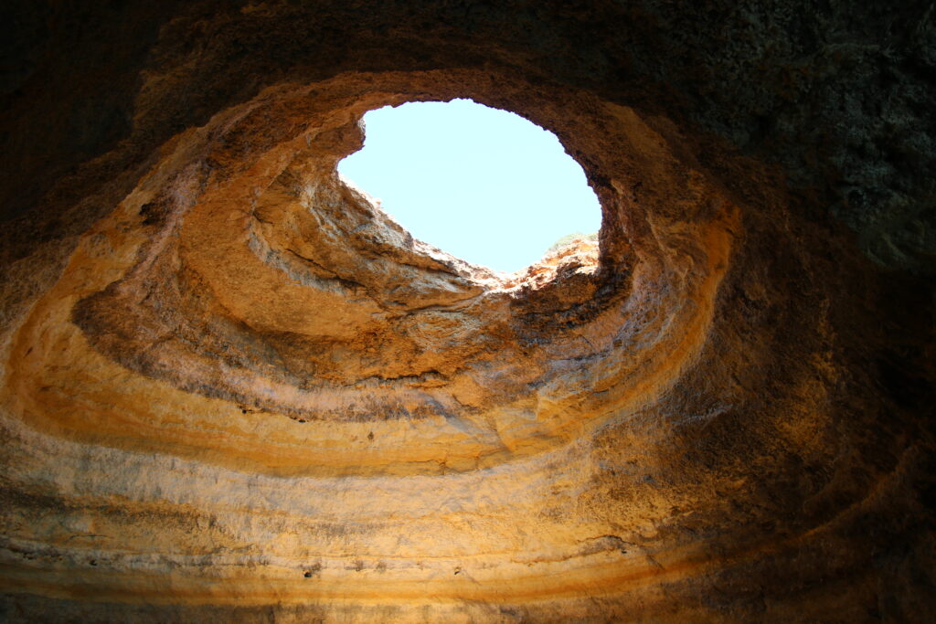
Then I stop in Benagil, where it is pleasantly busy. The small hamlet is located on a bay between high rocks. Benagil is a popular place for a boat trip, kayaking or supping. Reason: a beautiful stretch of coastline with cliffs and caves. The most famous, and very beautiful, is the Gruta de Benagil, a large cave with a hole in the roof through which the sunlight shines. It is reminiscent of the Panthéon in Rome, but natural. I also take a boat trip along the cliffs, the Gruta de Benagil and various other caves and rock arches and small sheltered beaches that can sometimes only be reached by water. Understandably this is a popular holiday destination; it’s a beautiful coastline.
The next two nights I will stay in Lagos. In the Middle Ages, Lagos was an important port. When Portugal began to look beyond its borders (and oceans) in the 15th century and the Age of Exploration began, it was one of the places where Portuguese explorers set out. The old center of Lagos is still partly surrounded by the fourteenth century city wall. Furthermore, Lagos is a modern town, aimed at the tourists who come here because of the beaches. But Lagos has a very different atmosphere than Albufeira, which is more aimed at the ‘nightlife crowd’.

Lagos invites you to take it easy. I take a look at Praia Dona Ana, a small beach surrounded by rocks that is symbolic of the Algarve, and then I take a leisurely stroll through the old town. Lagos does not have many sights, but it does have a few beautiful old buildings with azulejos and cozy squares with terraces. And on the harbor is the small fortress Ponta da Bandeira.
Lisbon
On Wednesday morning I drive to my last destination this trip: the Portuguese capital Lisbon. It’s a long drive of more than four hours. I return rental car and take the metro to my hostel. The weather is beautiful and sunny, ideal for exploring the city.
Lisbon is located on the river Tejo and built on seven hills. The history of the city dates back to the year 210 BCE. In that year the Romans conquered the Iberian Peninsula. On the banks of the Tejo they founded a new city, which became the capital of the new Roman state: Olisipo. After the Moors conquered the Iberian Peninsula in 711 CE, the city came to be known as Lishbuna. The Alfama (then al-Hama) and Mouraria districts still refer to the Moorish period. Ultimately it became Lisboa, Lisbon in English.

The Portuguese voyages of discovery and the expansion of the Portuguese empire made Lisbon a prosperous city. However, during the ‘Great Earthquake’ in 1755, a large part of the city was destroyed. The recovery took a long time. In the nineteenth and twentieth centuries, the economy did not go well, but a lot has been invested in the city since the beginning of the 21st century. Today Lisbon is a pleasant, modern city.
The Belem district, west of central Lisbon, is where explorer Vasco da Gama set out in 1497 on his way to India. His successful journey prompted the construction of the Mosteiro dos Jerónimos. The complex (a monastery and church), appropriately located on the Praça do Império, is huge and designed in the exuberant Manueline architectural style, as witnessed by the over-the-top decorated main entrance. The tomb of Da Gama is located inside the church. On the banks of the Tejo stands the Torre de Belém. A small fortress, built between 1515 and 1520, like the cloister with Manueline-style operations and intended to defend the mouth of the Tejo. Despite its modest size and location outside the center, the Torre de Belém is one of the symbols of Lisbon.

The central part of historic Lisbon is Baixa, literally ‘low’, to distinguish it from the neighborhoods next door, Barrio Alto and Alfama, which are both higher up. This part of the city was destroyed by the earthquake in 1775 and then rebuilt with a straight street pattern and stately buildings. Many streets are car-free and the area has many shops and restaurants. On the north side of the neighborhood is Praça Dom Pedro IV, commonly referred to as Rossio. This has been the main square of Lisbon for centuries. At the head of the main square is the Teatro Nacional de Dona II from 1848. Close to Rossio is the somewhat smaller Praça da Figueira.
If you don’t feel like walking up from Baixa to Barrio Alto, you can take the Elevador de Santa Justa. Built in 1902, this cast iron elevator was designed by a student of Gustav Eiffel. The somewhat strange-looking structure bridges a height difference of 32 meters.

On the south side of Baixa, bordering the waters of the Rio Tejo, is the impressively large Praça do Comércio square. The square is surrounded on three sides by yellow facades with colonnades below. In the center of the square is a statue of King Dom José, and on the north side, the imposing Arco da Rua Augusta, completed in 1873, provides access to Baixa. I think the square is perhaps the most beautiful place in Lisbon.
A pedestrian boulevard runs along the Tejo towards the Cais do Sodré district. From here you can also see the Ponte 25 de Abril, which is further away. This Golden Gate Bridge-like bridge was opened in 1966 and was initially called Ponte de Salazar. The bridge was named after António de Oliveira de Salazar, the authoritarian, far-right and widely believed fascist leader who came to power in 1932 and ruled Portugal with a heavy hand until 1968. The bridge’s new name, Ponte 25 de Abril, refers to the date on which Salazar’s regime fell.

Via the Mercado da Ribeira (a not very special market hall) I walk towards Barrio Alto, which literally means ‘high district’. The cobbled streets go up steeply (you can also take the cogwheel train Elevador da Bica). From the Miradouro de Santa Catarina you have a nice view over the river (but not the best view over the city, see later). West of Barrio Alto is the also elevated neighborhood of São Bento, home to the bright white parliament building Palácio de São Bento. A little further on is the Praça das Amoreiras, a green square with part of the Aqueduto das Águas Livres built in 1748 on the west side. This old aqueduct supplied Lisbon with water in earlier times.
Alfama is the oldest district of Lisbon. It’s a maze of narrow streets and steps up the hill. Here is also the cathedral, the Sé, and classic yellow trams run through the streets. The Largo das Portas del Sol square also offers a view over the city (but still not the most beautiful) and the cruise ship docked at the cruise terminal. Also in Alfama you will find many buildings with facades with Azulejos. And not only in Alfama by the way, you see them all over the city. In different colors and styles, with geometric shapes, with flowers (inspired by Delft blue tiles), with historical images, the style of the tiles changed over time and depending on the trends of the time.

If you walk up in Alfama, you will eventually come to the Castelo de São Jorge. This castle has served as a royal residence, as a military barracks and as a prison. From the outer fortress wall you have an amazing view over Lisbon and the Tejo (yes, this is the most beautiful one). Here you can see how the city is built on hills and is beautifully situated on the wide river. Next to Praça do Comércio, this is in my opinion the second most beautiful place in Lisbon.
I think Lisbon is a very pleasant, relaxed city. If I have to choose between Porto, where I started my journey, and Lisbon, I choose the latter. As far as I am concerned, it’s also a more beautiful and pleasant city than, for example, Barcelona or Madrid. Really good place to end my Portugal trip. After two weeks in Portugal, on Saturday afternoon it is time to go to the airport for the flight back to the Netherlands.


