Baltic States
Itinerary: Tallinn – Laheema National Park – Tartu – Cesis – Gauja National Park – Riga – Zemaitija National Park – Vilnius
If I had to summarize the three Baltic states, Estonia, Latvia and Lithuania, I would say: a turbulent history, beautiful old towns and quiet natural areas. And well worth a visit!
As for that turbulent history: over the course of centuries present-day Estonia and Latvia have successively been Danish, German, Swedish, Polish and Russian territory. From the beginning of the eighteenth century, the Russians were in charge and Tallinn (Estonia) and Riga (Latvia) became important Russian ports.
Lithuania has a somewhat different history than Estonia and Latvia. The Grand Duchy of Lithuania was founded in the thirteenth century and developed into a regional power in the fourteenth to sixteenth centuries. At the time the country was much larger than it is today and included parts of present-day Poland, Belarus, Russia, and Ukraine. The capital Vilnius was one of the largest cities in Eastern Europe. At the end of the sixteenth century, Lithuania’s power declined rapidly and after a union with Poland, the country became part of Russia in the second half of the eighteenth century.
After the First World War, the Baltic peoples fought for independence. Lithuania regained its independence in 1918. In 1919, Latvia became an independent country for the first time in history, followed by Estonia a year later. However, independence was short-lived. When Germany and the Soviet Union concluded the Molotov-Ribbentrop Pact in 1939, the Baltic states again fell under Russian influence. During the Second World War, the three states were occupied by Germany and after the war they became Soviet republics again. What followed was more than fourty years of totalitarian dictatorship.
In the 1980s, the striving for independence in the Baltic states grew and on August 23, 1989, fifty years after the Molotov-Ribbentrop Pact, two million Estonians, Latvians and Lithuanians formed a human chain from Tallinn via Riga to Vilnius to reinforce this aspiration. After the fall of the Berlin Wall and the collapse of the Soviet Union, the Baltic states (again) declared independence in 1991.
Nearly thirty years later, Estonia, Latvia and Lithuania are modern democracies and proud members of the European Union. In the cities, people live a western lifestyle and modern conveniences such as Wi-Fi and contactless payment are commonplace. They seem to have left the Soviet era far behind. Residents of the Baltic states who are now in their mid-20s have not experienced their country’s independence. They grew up in a modern democratic constitutional state and for them the Soviet era is something from the history books.
Tallinn, Estonia
I start my journey in Estonia, the northernmost of the Baltic states. Despite centuries of domination by foreign powers, Estonians have a strong historical and cultural national identity. Culturally, unlike Latvia and Lithuania, they are most closely related to Finland, despite the historical relationship with Russia. The Estonian language is also closely related to Finnish. Estonia has the fewest inhabitants of the three Baltic states: 1.3 million. Of these, 70% is of Estonian origin, a quarter is Russian.
I arrive at Tallinn’s modest airport on Friday afternoon and take the tram to the city center. After the collapse of the Soviet Union, Tallinn (which has a population of 415,000) has been modernized at a rapid pace and the old walled city has been renovated. This part, called Vanalinn, is now on the UNESCO World Heritage List. It turns out to be a surprisingly beautiful old city. Somehting more people have discovered: it is teeming with tourists. It is beautiful late summer weather: sunny and about twenty degrees, perfect for exploring the city.

Toompea is the oldest surviving part of Tallinn. In the fourteenth century a citadel was built on the hill of the same name. Part of the wall and three of the towers have been preserved. Within the walls of the citadel is a castle, which over the centuries has been rebuilt many times and does not really look like a castle anymore. The salmon-pink building is now the seat of the Estonian Parliament. Opposite is the Russian Orthodox Cathedral built in 1900. The rest of Toompea is made up of narrow cobbled streets dating back to the fifteenth century, with houses whose facades are painted in pastel colours.
From the Patkuli Vaateplats you have a beautiful view over the lower part of the old town. In that lower part is the Raekoja Plats, the town hall square. On the south side of the square is the town hall, built in 1404. On the other three sides of the square are stately buildings with pastel-colored facades, built in the fourteenth to the seventeenth century. Most of the buildings now house restaurants, with terraces on the square. The 64 meter high tower of the town hall, built in 1530, is open to the public. A narrow and steep spiral staircase (115 steps) takes you to the top of the tower, where narrow windows offer nice views over the rooftops of the old town and the citadel on Toompea Hill.
The next day I walk past the impressive cannon tower that goes by the Old German name ‘Kiek in de kök’, built in 1475 as part of the medieval fortifications of Tallinn. A little further on is Vabaduse Väljak, or Freedom Square, which is mainly used for large events. On the west side of the square is a large glass cross commemorating the war of independence in 1920.

Like Toompea, the lower part of the old town consists of picturesque streets, none of which, as befits a medieval center, run straight. Tallinn was once an important Hanseatic city, something of which the Great Guild House from 1410 and the stately houses along Lai (‘wide street’) and Pikk (‘long street’) are still a reminder. How different times intertwine becomes clear when you stand in front of number 59 in that last street: during the Cold War, this beautiful building housed the Estonian headquarters of the KGB, with cells and torture chambers in the basement. At the end of the street is the Suur Rannavärav, the medieval city gate on the north side of the old town, which gave access to the harbor. On the northwest side of the old town, much of the old town wall has been preserved, including nine (of the original 45) towers.
On Sunday morning I take the tram from Freedom Square to Kadriorg Park. After Russia annexed Estonia in the eighteenth century, Tsar Peter the Great had this park, including a salmon-pink palace, built for his wife Catherine between 1718 and 1736. Today, the park is open to the public, including the beautiful French-style gardens surrounding the palace, which now serves as a museum. On the edge of the Kadriorg Park stands the KUMU (short for Kunstimuuseum, the art museum), built in 2006. The modern, sleek museum has a permanent collection of Estonian painting and sculpture from the eighteenth century to the Second World War, and a floor devoted to art from the Soviet era. The museum is worth a visit.
Laheema National Park, Estonia
After three days in Tallinn, on Monday morning I pick up my rental car and leave the Estonian capital via highway 1. Don’t imagine too much with the word ‘highway’, most of the roads here are two-lane 80- and 90-kilometer roads. I pass exits to Stockholm and Helsinki, see signs warning of moose crossing, and if I follow this road long enough, I will automatically arrive in St. Petersburg. But that’s not where I’m going, my destination is Laheema National Park, an hour’s drive from Tallinn.
Laheema National Park was formed in 1971 and was the Soviet Union’s first national park. It covers 725 square kilometers of protected nature reserve along the north coast of Estonia. It is a wooded area, with mainly pine forests, but also farms and small villages, often no more than a few houses clustered together. You will also find large country houses of the former rich (often German) elite, which now often serve as hotels or museums, such as Palmse, dating from 1720, and Sagadi, built in 1753.

Estonia’s jagged northern coast, with peninsulas and bays, has been formed by glaciers over millions of years. The glaciers, which were up to a kilometer thick, brought large boulders from present-day Finland, and as the glaciers retreated due to the warming earth, the boulders were left behind. You can see these boulders everywhere along the coast and in the woods. The oldest boulders are estimated to be 1,600 million (!) years old.
I walk the 4.5 kilometer trail along the waters of Käsmu Bay, where large boulders lie photogenicly in the water. I enjoy the serenity by the water for a while and then continue through the pine forest. Except my footsteps, the rustle of the trees and some birds it is completely silent, there is no one else at all. There are large boulders everywhere, often covered with moss. The boulders vary in size, some are huge, such as the seven-meter high Majakivi boulder. The largest boulder is located in the forest near Tammispea and is no less than eight meters high.
After spending the night in the Sagadi country house, which has been converted into a hotel, the next morning I go to Altja, a small fishing village with no more than a few houses. Even during my walk here I don’t meet anyone. The trail runs partly along the coast, overlooking the Gulf of Finland. Until the end of the eighties this was the border of the Soviet Union and a high fence stood here along the coast. I walk along the rippling water, over stretches of beach at the edge of the pine forest, and sit for a while on a stump overlooking the water. The weather is beautiful and sunny and I take all the time to enjoy the serene tranquility.
In the afternoon I drive in two hours from Laheema National Park to the town of Tartu. The vast majority of Estonia consists of countryside, in the north almost flat, in the south somewhat more sloping. Because Estonia is sparsely populated, it is very quiet on the road. Some pieces seem almost deserted.
Tartu, Estonia
The next day I walk leasurely about the university town of Tartu. The weather is nice, but the first autumn leaves are already swirling around. Tartu is a relaxed town of less than 100,000 inhabitants. The old center can be visited in a few hours time.
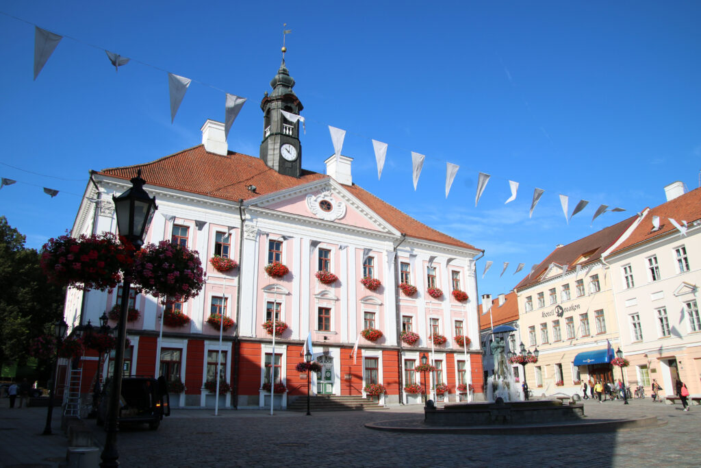
The heart of the old center is the triangular Raekoja Plats (Town Hall Square), with the pink/white plastered town hall on the west side. It was built between 1782 and 1789 and apart from the color the design is based on the traditional Dutch town hall. Stately classical buildings line the long sides of the square. In one of the side streets is the stately main building of the university, whose design with Doric columns is inspired by the ancient Greek temples.

Behind the town hall is Toomemägi, the Cathedral Hill, where a stronghold was built as early as the sixth century. On the hill stands the ruins of a Gothic cathedral, which was built here in the thirteenth century. The cathedral has been destroyed and rebuilt several times over the centuries. It is now part ruin and part museum. Under Toomemägi, the Püssirohu Cellar was built in the eighteenth century, a ten-meter high brick ammunition cellar, which now serves as a café-restaurant.
At the corner of Riia and Pepperi streets is a dark gray building that was the home of the KGB in the early 1900s, after Estonia was annexed to the Soviet Union. In the basement were the cells where political prisoners were held. After the occupation by the Germans, the KGB returned to the same building and would remain there until the fall of the Soviet Union. Many Estonians have been imprisoned, tortured, liquidated or sent to one of the prison camps in Siberia. The former cells now house a small museum, which is worth a visit.
Cesis and Gauja National Park, Latvia
I leave Estonia on Thursday. From Tartu one long road leads straight ahead to the border town of Valga (Estonian side) / Valka (Latvian side). Thanks to the fact that the Baltic States are now part of the European Union, you can drive across the border almost unnoticed. Latvia has 2.2 million inhabitants and consists almost exclusively of countryside, forests and nature. It is one of the least populated countries in the European Union and has only one real city: the capital Riga.
In two hours I drive to Cesis, a small village with a major attraction: the medieval castle. This castle was built in the twelfth century and consists – or rather: consisted – of a central courtyard surrounded by high, one and a half meters thick walls and four defensive towers. Just like you would draw a castle if you had to draw one. In 1577, the Russian Tsar Ivan (the Terrible) decided to conquer Cesis. When it became clear that the inhabitants of the castle were going to lose the battle, they decided they did not want to surrender. Instead, they used the stash of ammunition to blow themselves up. Hence the castle is now a ruin.
The castle is worth a visit, but a walk in the village that has arisen around the castle is also certainly worthy of your time. It is very picturesque, with old wooden houses and later built stone houses with peeling plaster on quiet cobbled streets.

I spend the night in an old country house again, a fifteen minute drive south of Cesis, in Gauja National Park. This park was founded in 1973 and is the oldest national park in Latvia. A large area with pine forest, grassland, rivers and farms. On Friday morning it’s cloudy, but dry and therefore good walking weather. I walk through the forest, towards the river Amata, and then along the river over sandstone cliffs. It is also wonderfully quiet here. A narrow path leads past a number of viewpoints, such as on the cliff of Ainavu. I also visit the Zvartes Iezes (‘black rock’), a photogenic red sandstone rock on the Amata. The area is not very spectacular, but it is a nice walk. And well timed, because the afternoon is rainy.
Riga, Latvia
With over 700,000 inhabitants, Riga is the largest city in the Baltic States. The city is located on the Daugava River and, like Tallinn, was once an important Northern European port. The compact medieval city center (Vecriga) consists of largely car-free cobbled streets. A moat once ran around it, which is now the Pilsekas Kanals (the City Canal), and the city expanded beyond it in the nineteenth and twentieth centuries. On the border between the old and ‘new’ part is the towering Freedom Monument, nicknamed Milda (which holds up three stars). The monument, with the inscription “for fatherland and freedom” was placed in 1935 and remarkably enough it has always been there – even during the Soviet era.
Riga’s Old Town has some pretty squares, such as Livu Laukums, a cozy square with terraces and eighteenth-century pastel-colored facades. The City Hall is of course located at Ratslaukums (Town Hall Square), but all eyes are focused on the building directly opposite: the Melngalvju Nams, or the House of the Blacks. Built in 1344, this building housed the Blackheads Guild, a guild for unmarried German merchants. The current building is a replica: the original did not survive the Second World War, but the original drawings did and the building was rebuilt in 2001 on the basis of this. The same goes for the town hall, which was also destroyed during the Second World War and rebuilt in 2003 according to its original design. In the middle of the square is a statue of the city’s patron saint, Saint Roland (I assume the statue is also a replica).

In the old town are many streets with beautiful old houses of wealthy merchants and you will also find a lot of Art Nouveau architecture. The most beautiful square in my opinion is the Doma Laukums (Dom Square). In addition to the cathedral, you will also find the red-brown brick building where the stock exchange used to be located (now a museum) and a photogenic south side with beautiful facades and terraces, where there is pleasant buzz thanks to the nice weather.
I continue my walk past Riga Pils (no, not beer, pils means castle in Latvian), the residence of the Latvian president, then down the Maza Pils Iela, where the three oldest houses of Riga are located (the oldest dates back to the fifteenth century, the other two from the seventeenth) and past the Swedish Gate, the only surviving city gate in Riga, built in 1698. Then down the Torna Iela, with the ocher facade of the sixteenth-century barracks building (which now houses restaurants) to the Pulvertornis (powder tower). Riga’s city wall once had eighteen towers and this is the only one still standing.

On Sunday, a rainy day, I visit the Latvian National Museum of Art, which is entirely devoted to Latvian painting from the sixteenth century to the present. It’s a nice museum, but I personally I think the works in the KUMU in Tallinn are more beautiful and interesting.
After the museum I walk about ‘Centrs’, the ‘new’ center of Riga, with wide streets and many beautifully designed buildings from the late nineteenth, early twentieth century. Now there are all kinds of shops, restaurants and coffee shops. In the last century, one of those buildings, known as ‘the Corner House’, housed the Latvian branch of the KGB. It is now the Museum of the Occupation of Latvia, which tells the story of the horrors of the totalitarian communist regime and the resistance against it. Interesting detail: the building is located on what is now called Brivibas Iela, which translates as Freedom Street.
Zemaitija National Park, Lithuania
On Tuesday a long car ride is planned, during which I leave Latvia and drive into Lithuania. When I cross the border at the village of Eleja, I notice that on the Latvian side the old customs post is still there. The road now runs around it and you drive unhindered from Latvia into Lithuania. In Lithuania most roads are two lanes as well and not very busy. The area is slightly sloping and is mainly covered by agricultural land. Lithuania is the largest of the three Baltic States in area and has more than 3.5 million inhabitants. It is also the most homogeneous country of the three: 85% of the inhabitants are Lithuanian, 6% Polish and 5% Russian.
My destination for today is Zemaitija National Park, which is located in the northwest of Lithuania. Deep in the woods lies a former Soviet Union nuclear missile base. The Plokštine base was built in the deepest secrecy in the 1960s, at the height of the Cold War, far from civilization. While the United States and the Soviet Union were engaged in an arms race, the Russians placed medium-range missiles here, intended to target Western Europe in the event of war. The base is now open under the (perhaps somewhat exaggerated) name Cold War Museum.

After passing the barbed wire fences, you’ll come to four domes that form the tops of the underground missile silos. Through a small door you descend to an underground bunker, where, among other things, the control rooms and the quarters of the military were located. Via various corridors and steel doors you arrive at one of the thirty meter deep missile silos. It’s a bit creepy place to walk around, especially when you consider what its purpose was. A very special place to visit.
After a rainy afternoon, the next morning the weather is nice for a few hours. I take the opportunity to take a walk in Zemaitija National Park. I do that on the west bank of Lake Plateliai, where it is still wonderfully quiet in the morning. In an hour and a half I walk back along the lake and through the forest. Then I drive in 3.5 hours to my last stop this trip: the Lithuanian capital Vilnius.
Vilnius, Lithuania
Vilnius has 550,000 inhabitants and therefore in size sits between Tallinn and Riga. Like the old town of these cities, the old town of Vilnius is also on the UNESCO World Heritage List. I start on the south side, at the Aušros Vartai, which roughly translates as the Sunrise Gate. It is the only surviving city gate in the old city wall that once surrounded all of Vilnius. From here I walk down the streets of the old town, which is full of churches and baroque buildings. I walk along Rotušes Aikšte (Town Hall Square), down small backstreets and the main street Pilies Gatve.

On the north side of the old town you come to the Katedros Aikšte (Cathedral Square), so called, of course, because of the large cathedral that stands here. Not a Gothic cathedral as you often see, but a huge snow-white building with a classical facade with high Doric columns. On the square in front of the cathedral is a 57 meter high and equally snow white bell tower.
Next to the cathedral is the Palace of the Grand Dukes of Lithuania. The original palace has been expanded, destroyed and rebuilt several times. The current version is relatively new, but built as it must have looked in the seventeenth century. On the other side of the cathedral is the National Museum, in front of which is a statue of the only king Lithuania ever had: King Mindaugas.
Vilnius was founded in the thirteenth century on Gediminas Hill, where a fortress was built. Only the red-brick watchtower of that fortress remains, a version of it built in the fifteenth century. From this tower you have a beautiful view over the whole of Vilnius. Down the fifteenth and sixteenth-century streets, I pass the Presidential Palace and the beautiful Vilnius University campus. Founded in 1579, the campus consists of a cluster of sixteenth-century buildings surrounding thirteen courtyards, including the beautiful Great Courtyard. The buildings are still in use as university buildings and are therefore buzzing with students.

On Fridays, I walk about in the ‘new’ part of Vilnius, that is, the part that was built in the nineteenth century and now forms the center of the city. Here you will find wide boulevards, such as the main street Gedimo Prospektas, with shops, restaurants, cafes, hotels and theaters. On the north bank of the river Neris there used to be mainly gray apartment buildings from the Soviet era, but in recent years a new, modern ‘business district’ has been built here. With modern high-rise buildings, offices and shopping centers.
After a relaxed Saturday, I report to Vilnius airport on Sunday morning for the return flight to the Netherlands. However, my flight appears to have been canceled – for unknown reasons. That has never happened to me in all my years of traveling… The airline has booked me an alternative flight, or rather two: I first fly from Vilnius to Moscow and then from Moscow to Amsterdam. I’m glad I can go home, even if it’s with a detour and a total delay of about ten hours…


