Philippines
Itinerary: Manila – Coron Island – El Nido – Bacuit Bay – Panglao – Bohol – Siargao
The Republic of the Philippines is a vast archipelago in Southeast Asia. Officially the country has 7,641 islands, but that depends a bit on your definition of island.
The Philippines is the only country in Asia that was a Spanish colony. In 1521, Spanish explorer Ferdinand Magellan arrived and claimed the islands that now form the Philippines as Spanish possessions. Unfortunately for him, he was killed in fighting shortly afterwards, after which the Spanish explorer Villalobos tried again in 1543. Villalobos named the islands after the Spanish king Filipe, but he was also expelled. It was not until 1565 that Miguel López de Legazpi managed to colonize the islands of Bohol and Cebu and in 1571 the new capital Manila was founded. From then on, the Philippines became part of the Spanish colony of Nueva España, which also included present-day Mexico.
Like everywhere else, in the Philippines, aversion to colonial rule and the desire for freedom started to grow over time. In their quest the Filipinos were strongly inspired by the writer José Rizal, now a national hero. Rizal was executed in 1896 because he was suspected of masterminding a violent uprising that year.
In 1897, the Republic of the Philippines was proclaimed, with Emilio Aguinaldo as president. However, he could not resist Spain’s offer to leave the country with a large sum of money. A year later, the American-Spanish war broke out and during this war the US expelled Spain from the Philippines. Aguinaldo returned from exile and Philippine independence was again proclaimed in January 1899. In reality however, the US took over Spain’s role as colonizer, leading to the Philippine-American War, which was won by the US three years later in 1902. The US granted the Philippines autonomy, but not independence.
What followed was a period of American assimilation. English became the official language and the Philippines was the first Asian country to introduce democracy. Even today, the culture in the Philippines still differs from many other Asian countries. For example, the majority of Filipinos are Catholic and you will find more Spanish and American influences than for example Chinese. In 1942 Japan invaded the Philippines. After two years of war, the Japanese were expelled with the help of the US and on July 4, 1946, the Philippines finally gained their long-sought independence.
The following decades have shown that independence is not the solution to every problem. Power in the Philippines is concentrated among the military and a handful of wealthy families. There is widespread corruption, great social inequality and poverty, drugs and prostitution are still major problems. Meanwhile, the population of the Philippines has exploded in recent decades: sixty years ago the country had 27 million inhabitants, today there are 115 million. An estimated twelve million of them live and work abroad.
Manila
After a short two-hour flight from Taoyuan International Airport in Taiwan, I land around 6 p.m. at Ninoy Aquino International Airport, which is located in the middle of the Philippine capital Manila. Passport control goes very quickly and then I take a taxi into the city. I immediately end up in the Friday evening rush hour, although traffic in Manila kind of resembles a permanent rush hour.

Manila was founded in 1571 and is centrally located on a bay on the largest island of the Philippines: Luzon. Manila is part of a huge urban area called ‘Metro Manila’, which consists of sixteen cities that have grown together. In total, Metro Manila has no less than twelve million inhabitants. Many international travelers skip Manila when they visit the Philippines. However, the city does have some interesting sights that are worth seeing and that is why I spend a day and a half there.
I start my first day in Manila in Rizal Park. Originally this green square was called Luneta, but in 1967 it was named after beforementioned writer José Rizal. At the head of the square is a statue of Rizal and the spot where he was executed is also marked. Rizal Park is also where the independence of the Philippines was declared on July 4, 1946. So it’s a historical place.
North of Rizal Park lies Intramuros. This is the oldest part of Manila, a fortress built by the Spanish in 1571. As the name suggests, Intramuros is walled and it is a kind of city within the city. During the Battle of Manila at the end of World War II, Intramuros (like the rest of Manila) was largely destroyed. After the war, most of the buildings were rebuilt. Such as the Manila Cathedral, originally built in 1580, and a number of colonial mansions, such as Casa Manila, which originally dated from 1850.
On the northwest side of Intramuros, at the end of Plaza Moriones, you will find Fort Santiago (or what’s left of it). Built in 1571, this fort was the seat of the Spanish and American colonial rulers. During the Second World War, the Japanese occupiers took up residence there. You enter the fort via a bridge over a moat and through a gate originally built in 1714. Within the walls of the fortress is Plaza de Armas, with a statue of (who else?) José Rizal. On the left is the place where Rizal was imprisoned.

Ammunition was initially stored under the Casa del Castellano, on the north side of the fort, from 1599 onwards. Later the rooms were used as a prison. In 1945, six hundred bodies of Filipino and American soldiers were found here who had been abandoned by the Japanese and died of starvation and suffocation. A white cross marks their mass grave.
In the afternoon I walk along the Manila Baywalk and on the artificial beach Dolomite Beach, with a view over the water of Manila Bay and the high-rise buildings of central Manila. In short, Manila is big, busy and hot. There is a lot of traffic (as mentioned, it seems to be permanent rush hour), with not only cars but also many motorcycles, scooters, tuktuks, rickshaws and so-called Jeepneys. These are a kind of extended Jeeps, painted in bright colors and with lots of chrome. Originally, Jeeps were used that were left behind by the Americans, but nowadays they are produced by the Philippines themselves. Jeepneys are a form of public transport widely used by locals.
What is also striking is the visible poverty. In addition to slums elsewhere in the city, many people also live in poor conditions in the center of Manila. There are many homeless people and children begging on the streets. The contrast with the modern shopping centers and other modern facilities that are only accessible to the affluent middle class or Westerners like me is stark.
The next morning I visit the National Museum of Fine Arts, on the north side of Rizal Park. The building in which this museum is located was built in 1926 as a parliament building. Afterwards, it housed the Philippine Senate and, since 1996, the National Museum of Fine Arts. This free-to-visit museum mainly features paintings, statues and sculptures by Filipino artists. I think the museum is very worthwhile (and I think it’s quite special that it is admission-free).

Coron Island
After my museum visit, I take a Grab to the airport on Sunday afternoon for my flight to the island of Busuanga, in the province of Palawan, in the west of the Philippine archipelago. It is a short one hour flight. The plane lands with a bang (a combination of a small propeller plane and a not-so-smooth runway). I arranged a transfer through my hotel to Coron Town (which, somewhat confusingly, is not on Coron Island), on the south side of Busuanga, which is half an hour’s drive. Anyone who thinks that after Manila a small village on an island will be an oasis of peace is wrong. Coron Town is tourist central. It is teeming with Western tourists, restaurants, hotels and tour companies.
I’m here to do a tour to Coron Island by banka the next day. Bankas are narrow boats with a float on both sides, which you see everywhere in the Philippines. They come in all sizes, from small fishing boats to large boats that take groups of tourists to beautiful places. Coron Island is a fifteen-minute boat ride south of Busuanga. The weather is beautiful and the tour lasts all day. The landscape of Coron Island is spectacular: limestone cliffs with sharp points rise vertically from clear turquoise water.

We stop first at Lake Kayagan. Or actually in a lagoon with clear water, surrounded by cliffs. From there it is a short walk to Lake Kayagan. Halfway there is a viewpoint with a beautiful view over the lagoon, where dozens of bankas are moored. You can swim and snorkel in Lake Kayagan, which unfortunately quite a lot of visitors do, which means that the beautiful place does not really feel idyllic. The Twin Lagoons are also surrounded by limestone peaks and at various places around the island you can view the coral while snorkeling among fish. The tour ends on the beach Beach91, which also has clear turquoise water. A well worth tour.
El Nido
Early on Tuesday morning I go by tuk tuk to the port of Coron Town to take the ferry to El Nido. A crossing of about five hours. The ferry is old and noisy and inside it smells of diesel. The fact that the boat is old becomes apparent when, after two hours of sailing, it is suddenly announced that we are going back. There is a mechanical problem, so we turn around, to the bewilderment of most of the passengers. After we have sailed back a bit, the ferry suddenly turns around again. Apparently the mechanical problem has been solved, we are going to El Nido after all. There is relieved applause from the passengers.

With an hour’s delay we arrive at the port of El Nido, located on the northern tip of the island of Palawan (main island of the province of the same name). El Nido is really a tourist village, but it has a more laid-back atmosphere than Coron Town. I walk to my hotel, check in and then walk to the bay. El Nido is located on a beautiful bay with clear blue water, between mountains and with a view of a number of islands. There is a beach along the water and bankas sail back and forth.
For the next day I booked a boat tour to the Bacuit Bay, off the coast of Palawan. On a spacious and luxurious banka we sail past the many islands and outcrops in the bay, including Shimizu Island, Entalulu Island and Snake Island. Steep limestone cliffs everywhere, clear turquoise water, idyllic beaches and scenic lagoons. It’s a beautiful photogenic environment.

Panglao/Bohol
My next stop on my Philippines trip is Panglao Island, in the middle of the Philippine archipelago. Panglao is a small island next to the larger Bohol, to which it is connected by two bridges. The village of Panglao is not much, you will mainly find tourist restaurants and bars and the popular, but not very beautiful Alona Beach.
On Saturday I’m going on a tour of Bohol. First we visit the Chocolate Hills. In the middle of the island there are a large number of rounded hills, on average about forty meters high, in an otherwise flat landscape. There are said to be around 1,776 of them and they were probably formed by the deposition of coral and limestone which then took their current shape through centuries of erosion. The hills are green when I visit them, but in the summer they turn brown, hence the name Chocolate Hills. There is a busy viewpoint on one of the hills, from which you have a beautiful view of the somewhat quaint landscape.
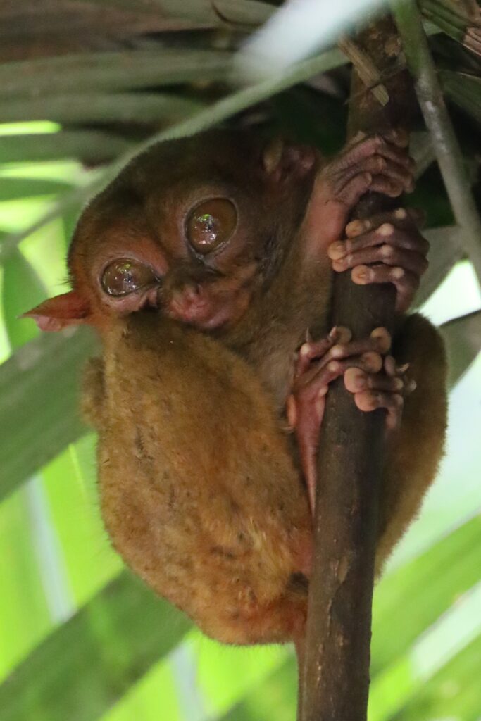
After the Chocolate Hills we go to the Philippine Tarsier Sanctuary. Tarsiers are the smallest primates in the world; They are only four to six inches tall and have relatively huge eyes (their eyes are bigger than their brains), long fingers and a long tail. The little fluffy creatures have been around for 45 million years, but are now under threat to become extinct. They were once found in many places around the world, but now only in a few places in the Philippines, Malaysia and the island of Borneo. You can only see the Philippine tarsier in real life in Bohol. They are most active at night, during the day you can spot them in the sanctuary sleeping on branches, although I also see a few that are awake. Super cute creatures.
Lunch during the tour is on a boat sailing on the Lomboc River. It is very touristy and I would have preferred to avoid it, but it is just part of the tour. After lunch we stop at a ‘man made forest’, it’s not entirely clear to me why. I love walks in the woods, but this is just a stop at the side of the road. And the last stop is at a church, which is not really my thing. However, the Chocolate Hills and the Tarsier Sanctuary were worth the tour.
Siargao
Saturday is another travel day. First I am taken to the port of Tagbilaran, from where I take the ferry to Cebu City. After an hour and fifty minutes of sailing we arrive and I take a Grab to the airport. From there I fly in an hour to the island of Siargao, at the very eastern end of the Philippine archipelago. From the Sayak Airport on Siargao I am taken to my hotel, just outside General Luna, the largest village on Siargao. I arrive at the beginning of the evening.
Another tour is scheduled for the next day. Near Siargao there are three islands that you can visit by banka. The first is Naked Island, which takes its name from the fact that no palm trees grow there. Actually it is no more than a large sandbank. Daku Island is a lot bigger (but still not that big) and has palm-fringed beaches. The third island is Guyam Island, a small, round island with white sand and palm trees, basically as you would draw a tropical island.

Siargao is so far from islands like Palawan and Coron in the west of the archipelago that they have different monsoon seasons. While the weather was bright and sunny in the west, the weather in and around Siargao is changeable. There is a strong wind and in the course of the day a few light showers fall from the constantly threatening clouds, but there are also moments with blue sky and some sun. The islands we visit are worthwhile, but also very popular, which has the disadvantage that they are overrun by visitors. We have quite a lot of time on each island (the tour could perhaps be done in half a day), but that also makes it relaxed and not rushed.
I don’t do much the last two days of my trip. It’s time to relax. On Tuesday morning I walk from my hotel to Tuason Point, better known as Cloud 9. From my hotel this is a walk of about three kilometers. Cloud 9 is mainly known among surfers. There is a beach with coconut trees and beach bars, and a wooden pier with a pavilion at the end overlooking the Pacific Ocean. I stay here for a while and then walk back. It is a hot walk, because the weather is sunny.
I spend the rest of the time on a lounge bed by the pool of my hotel. On Thursday I check out and then the long journey home begins. First from Siargao to Manila (a two-hour flight), then from Manila to Singapore (a three-hour flight, which I barely make because I only have an hour’s transfer time and passport and baggage checks take a lot of time) and finally the long flight from Singapore to the Netherlands (13 hours). It is a 6:45 a.m. local time on Friday when I land at Amsterdam International Airport Schiphol. Enter jet lag. 🙂