Mountain States, USA
Itinerary: Rocky Mountain National Park – Denver – The California Zephyr – Shoshone Falls – Sawtooth Range – Stanley – Bitterroot Valley – Missoula – National Bison Range – Glacier National Park – Helena – Cody – Yellowstone National Park – Grand Teton National Park – Fort Collins
Rocky Mountain National Park
There’s really no reason you should visit Estes Park, other than that it’s on the edge of Rocky Mountain National Park. It is a real tourist village, with souvenir shops, some restaurants and I count at least five shops that sell Christmas stuff (and that are open all year round). Estes Park is my first overnight stop on this trip, which will take me to five states in two weeks: Colorado (a small piece of) Utah, Idaho, Montana and Wyoming. These are the ‘mountain states’, so called because of the Rocky Mountains, the enormous mountain range that runs over a distance of 3,200 kilometers from north to south across the American continent. The Rocky Mountains are about 65 million years old and formed by glaciers that carved deep valleys and left behind mountain lakes during the last ice age. (65 million years seems to be relatively ‘young’, the Blue Mountains on the east coast of the USA are 200 million years old!)
I arrived at Denver International Airport at 5:30 p.m. local time. After clearing customs and collecting my luggage, I get my rental car and drive via interstates 70 and 25 and highway 34 to Estes Park. The last part is an unlit winding road down a valley and it is already dark, I can just see the contours of the mountains. During the day it’s probably very beautiful here, but now I’m mainly concentrating on the road. At ten p.m. I arrive at the lodge where I will stay the first two nights. It has been a long day of travel, so I immediately go to bed. The next morning I get up early and at eight a.m. I report to the entrance of Rocky Mountain National Park. Here I immediately purchase a National Park Service Annual Pass – I will visit several national parks this trip and such a pass is cheaper than paying for each national park separately. The weather is beautiful, the sun is shining in a clear blue sky.
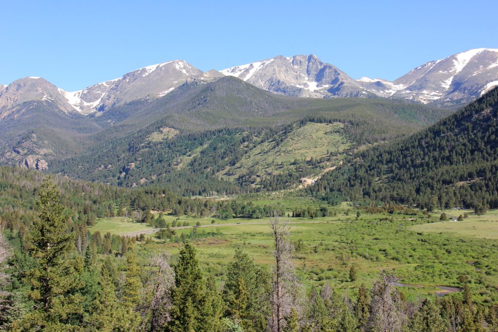
This part of the Rocky Mountains has been a national park since 1915. The park covers approximately 1,100 square kilometers and that is – contrary to the name of the park – only a very small part of the Rocky Mountains (for comparison: Yellowstone National Park is ten times as large…). The Trail Ridge Road runs from east to west, across the continental divide and at an average elevation of over 3,000 meters. This 72-kilometer road is the highest paved road in the United States. It is a good idea to set out early in the morning, to enjoy the area quietly, before it gets really busy after 10 a.m..
From the Fall River entrance to the park, the road climbs quickly, winding along the mountain slopes. You start at about 2,400 meters and the highest point of the Trail Ridge Road is over 3,700 meters above sea level. Rocky Mountain National Park has three climatic zones: mountain climate up to 2,700 meters, where many conifers grow and beavers, squirrels and moose live; sub-alpine between 2,700 and 4,500 meters, where there is still snow in many places and meltwater runs down the slopes between the trees; and alpine above 4,500 meters. This part, the tundra, which takes up a third of the park, is above the tree line. The mountain peaks here reach a height of between 3,900 and 4,200 meters.
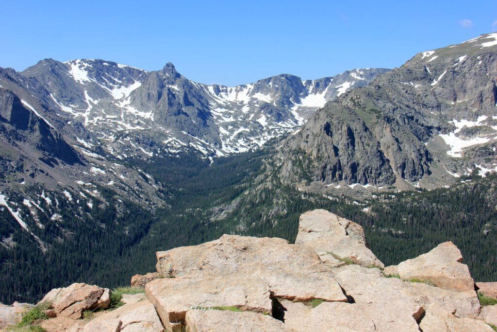
Along the way, you will be presented with one breathtaking view after another. Stops have been made at many spots along the Trail Ridge Road, with names like Horseshoe Park, Many Parks Curve, and Forest Canyon. Wide views, impressive, partly snow-capped mountain peaks and deep, green valleys. As you go higher, it gets colder and the wind blows harder. Still, I walk in a t-shirt and flip flops… I’m driving up to Milner Pass. Here, at an elevation of 3,280 meters, runs the Continental Divide. The water west of this point flows toward the Pacific Ocean, the water eastwards into the Atlantic Ocean.
The next day I visit the Bear Lake Area, the most visited part of Rocky Mountain National Park. So I get up early again, but even if you’re there at eight, you’re not the first. In fact, dozens of others have already preceded you. But yes, what do you expect: the weather is beautiful and the surroundings are magnificent. Bear Lake is a small lake surrounded by pine trees and mountain peaks. Very photogenic! From Bear Lake, it’s about a two-mile walk to Dream Lake, which is, if possible, even more scenic. A path leads up around Dream Lake and from there you have a beautiful panoramic view of the mountains, forests and Dream Lake below. A beautiful place, where many people sit on the rocks to enjoy the view.
After my visit to the Bear Lake Area it is already time to leave the Rocky Mountain National Park. I drive back to Denver via highway 36 and return the rental car. After I have brought my luggage to my hostel, I walk about the city. It is sunny and hot at 33 degrees. The capital of Colorado is also called the ‘mile high city’ because the city is one mile above sea level. It’s not a pretty city and I can’t really think of a good reason why you should come here. The center consists of many high-rises, which replaced the old buildings from the days when Denver was still a ‘frontier’ city in the 1980s. The State Capitol is one of the few old and striking buildings. The Rocky Mountains loom in the distance from the steps of the building. 16th Avenue is a pedestrian zone, where on this Sunday afternoon the public strolls past stalls and sits on terraces.
The California Zephyr
It is 7 a.m. when I am having my breakfast on a terrace at Union Station, consisting of coffee and bagels. I took the free shuttle bus that connects the Civic Center with Union Station, which is another plus to Denver. Union Station was built in 1881 and has a beautiful, monumental central hall, which exudes the grandeur of the heyday of train traffic. The California Zephyr departs from here at 8 am.. This famous train runs from Chicago in Illinois to San Francisco in California in five days. I’ll only be riding the section between Denver and Salt Lake City, a fifteen-hour drive straight through the Rocky Mountains.
After I’ve checked in my luggage (just like when you’re flying) I join the queue on platform 4. At a quarter to eight, the Zephyr slowly backs into the station. High, two-layer railcars made of silver-coloured steel of the national train company Amtrak with two heavy diesel locomotives in front. The trains look a bit outdated from the inside, but the compartments are very spacious and the seats are comfortable and – not unimportant – you have a good view out the large windows.
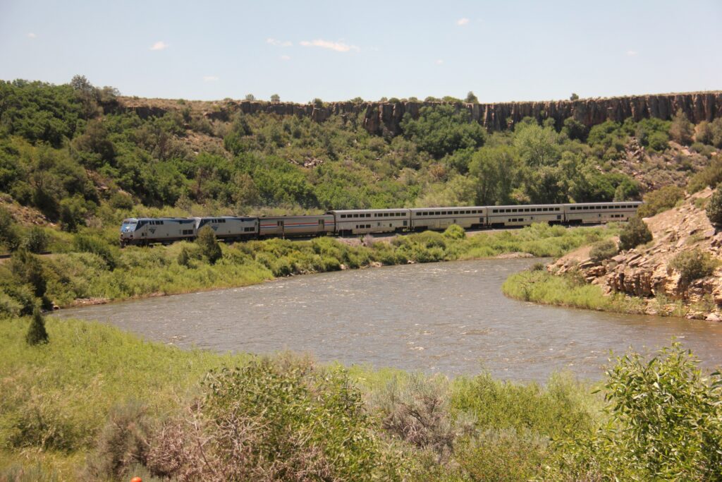
Leaving the suburbs of Denver behind us, we ride at a leisurely pace into the foothills of the Rocky Mountains. Along the way, the driver regularly tells us where we are and what to see outside, each announcement starting with a cheerful “All rightie folks!”. He also says that the Zephyr will climb from about 1,500 meters to 2,700 meters in the coming hours and that we will drive down no less than 27 tunnels in the so-called Tunnel District in half an hour. One of those tunnels is no less than 9.6 kilometers and was built in the 1920s. They started digging on both sides of the mountain, and when they met in the middle, the two tunnel tubes were only 7 inches apart!
We soon drive into the mountains, between the pine trees, along rocks and streams and rivers, down wide valleys and narrow gorges. The mountains range from brown to deep red and yellow. It really is a beautiful train ride. On the beautiful parts I enjoy the view, on the less interesting parts I read about – appropriately – the Zephyr in my book. Halfway through the drive, we pass the Zephyr traveling eastwards on its way to Chicago (the “6”, the “5” is the one heading west). Along the way we stop in Fraser, Grandby, Glenwood Springs, Grand Junction, Great River and Helper, all small hamlets. After Glenwood Springs the mountains get lower and the valleys wider and just before Grand Junction I actually see a number of vineyards. The entire stretch before you saw the occasional farm or road, but as we approach the Utah border, we are clearly back in civilization again. On the border of Colorado and Utah we are treated to the spectacular red cliffs of the Ruby Valley and moments later… we stop. In the middle of the desert of northern Utah. It turns out: in front of us is a freight train with breakdown. We were already behind schedule, but because of this delay we lose an extra hour. The sun is already setting when we continue driving. We don’t arrive at Salt Lake City station until 1 a.m., two hours later than planned. I take a taxi to my hostel, where everything and everyone is already asleep.
Sawtooth Range
After only a few hours of sleep, I wake up at 6 a.m.. I take a shower, pack my things and get coffee and bagels for breakfast at Starbucks. Then I can get my rental car. I’m not staying in Salt Lake City, but heading north this morning heading for the state of Idaho, north of Utah. Interstate 84 runs largely through uninteresting landscape, so: air conditioning, cruise control and radio on, and off you go! After three hours of driving I stop at Shoshone Falls Park. The falls are not much, but the adjacent park is a great place to have lunch. After another stretch of bland landscape, the mountains of the Sawtooth Range loom right in front of me, a mountain range that is part of the Rocky Mountains. It is a prelude to the beautiful surroundings of central Idaho.
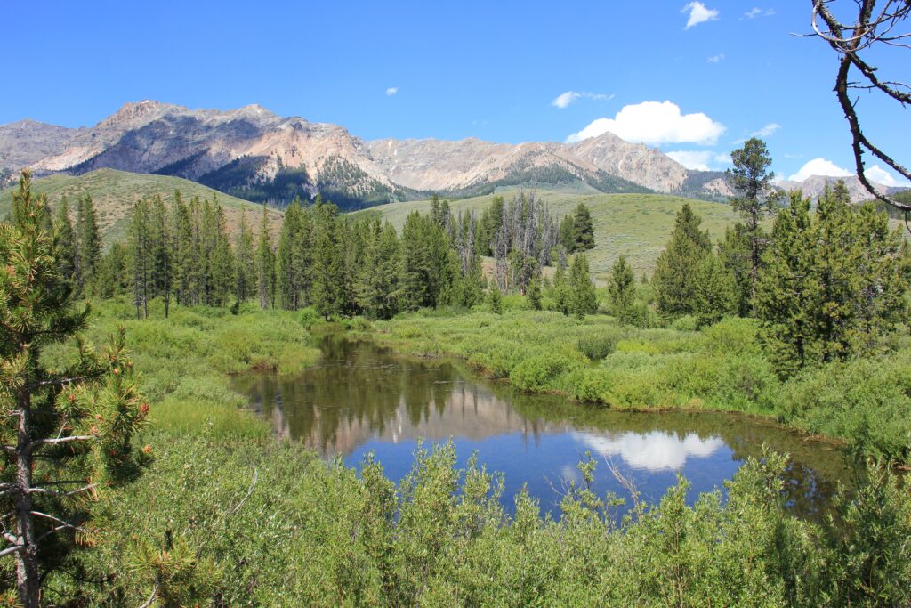
Idaho is a less known state and there are therefore few tourists. Too bad, because it is really beautiful. Towering granite peaks, vast pine forests, fast-flowing rivers, lakes and valleys. Oh yes, and the occasional crossing deer. Amazingly, Idaho is one of the few states without a national park (you do have other nature reserves, which go by the name ‘national wilderness’ or ‘national recreation area’).
Highway 75 runs through the Sawtooth Range as a scenic byway and it is definitely scenic! Especially the area around the Galena Summit, at 2,650 meters the highest mountain in the Sawtooth Range, is breathtakingly beautiful. There is still snow on the mountain tops, while it is 38 degrees in the exuberant green valleys. At the beginning of the evening I arrive in Stanley, a small village, consisting of some wooden houses, two ‘country stores’, some motels and restaurants and a real saloon. You get it: Stanley has the air of an old-fashioned wild west town. Tonight I sleep in a wooden log cabin, I eat on the veranda of one of the restaurants, on the Salmon River and with a view of the Sawtooth Range.

It cools down considerably at night in the mountains and it is therefore crisp when I get up the next morning. At half past eight I continue my way along highway 75, which is called the Salmon River Scenic Byway here. Despite the name ‘highway’, this is a not too wide two-lane road, which winds between the mountains, continuously following the Salmon River. It’s a beautiful route. After every bend you get a new view. The byways in the United States are usually not the fastest routes from a to b, but they are often the most beautiful!
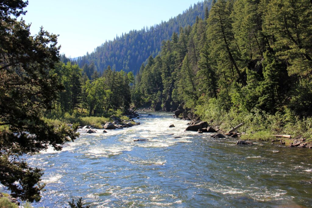
From Challis, the road leads down the Round Valley, where the mountains are a bit lower and more rounded and barer, but the soil more fertile. There are some farms and ranches and every now and then I pass through a small hamlet, but it is not very densely populated here. At one point the road starts to climb and I pass the Lost Trail Pass, on the border of Idaho and Montana. On the other side of the pass, highway 193 plunges into the Bitterroot Valley, with the Bitterroot Mountains on the left. I drive through old frontier towns like Darby and Hamilton and arrive in Missoula in the afternoon. Missoula is a nice university town with quite a few old buildings and a relaxed atmosphere. It is sweltering hot (almost 35 degrees), but I still walk around town, after which I seek out the coolness of one of the trendy coffee bars. Relax after a long drive.
The next day I don’t have to drive that far, so I have plenty of time. During my breakfast (yes, coffee and bagels again) I read on the news that a cyclist was killed by a grizzly bear at Glacier National Park yesterday. So that’s where I’m going tomorrow… After going to the local branch of the Barnes & Noble bookstore, I take highway 93 to the north. In the agricultural environment of the Mission Valley is the National Bison Range. About five hundred bison live here – so you should expect to see a lot of bison. But it is a bit disappointing. I see a couple of bison lying lazily in the grass from a little closer and a grazing herd so far away that they could also be cows. I do see deer and bighorn sheep though. I continue my way north, around Flathead Lake, the largest freshwater lake west of the Mississippi and popular with boaters. My destination today is Kalispell, my base for Glacier National Park, tomorrow.
Glacier National Park
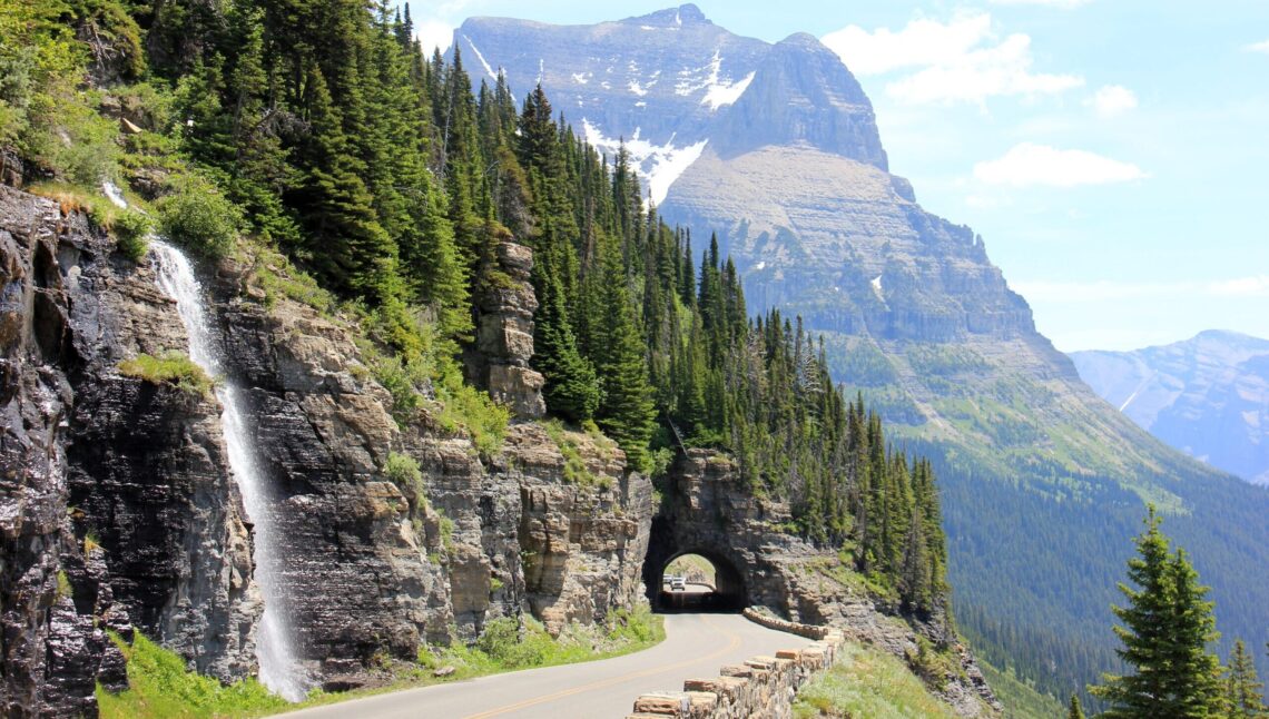
Friday again. Today the highlight of this trip is on the program, as well as the highest point I will pass during this trip: Logan Pass is located at more than 2,000 meters. The area that has been Glacier National Park since 1910 was formed by huge glaciers millions of years ago. The result is granite peaks, u-shaped valleys, streams, rivers, lakes and waterfalls. The area has only been accessible since the construction of the Going to the Sun Road, which was completed in 1923. The road is a fine piece of work, especially for that time. In that year, Glacier National Park was also merged with Waterton, on the Canadian side of the border and since 1995 the park has been a UNESCO World Heritage Site.
One of the most spectacular roads on Earth, the Going to the Sun Road cuts through Glacier National Park, west to east, 95 kilometers long and generally open from mid-June to early October. The rest of the year the road is impassable due to snow. It is a beautiful route to drive, every bend provides new panoramas. For the first part, the road winds past Lake McDonald between the trees, along McDonald Creek, after which the road begins to rise. Where the road makes a hairpin turn to the right called The Loop, the view is amazing. The road winds further along the rock face, where meltwater flows down. In many places there is still snow on the mountain slopes, although a lot of snow has already melted due to the high temperatures of the past few days.

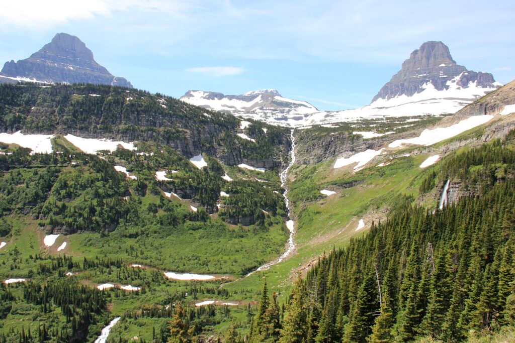
The pinnacle of the Going to the Sun Road is Logan Pass, which sits right on the Continental Divide. This is also the starting point of the Hidden Lake Trail, a three-mile round trip hike. Although that distance is not long, in the meantime you climb from 2,025 meters to 2,175 meters and a large part of the trail is still snowy. That makes it a beautiful, but also slippery walk. The sun is high in the sky and despite the snow it is quite warm. The area is truly beautiful, surrounded by the mountain peaks of Clemens Mountain (over 2,650 meters) and Reynolds Mountain (2,775 meters). After almost an hour of walking, the path goes down slightly and you come to a small lake. A breathtakingly beautiful spot!
You then have to climb around a cliff like some sort of mountain goat, after which you arrive at the Hidden Lake Lookout, the end point of the trail. Here you have a fantastic view over the lower lake with the Gunsight Mountain in the background. Wonderful! At one point there is some excitement among the visitors: a little further on, two mountain goats are being chased by a bear. It’s a long way off, so the bear is just a speck, but fun nonetheless. In total I spent two hours on the trail. It is slippery and you have to be careful not to fall. Flags are at half-mast at the Visitors Center, following the cyclist’s death two days ago. It almost never happens, but it underlines what you’re being warned about everywhere: this is bear country.
From Logan Pass it is about 29 kilometers to St. Mary. The first part you will be treated to beautiful views, including the Jackson Glacier (which unfortunately melts further and further over time). Then the road descends again and ends as it began: along a lake: Lake St. Mary. I started early (to avoid the worst crowds, the Going to the Sun Road is very popular) and therefore finished quite early. I spend the rest of the afternoon sitting on the balcony of the lodge in St. Mary, with a book and a local – aptly named – Going to the Sun beer.
The next morning (I’m already halfway through the trip) I visit another part of Glacier National Park: the Many Glacier Area, which is slightly more to the north. Despite the name, you should not expect huge glaciers here either, because they have largely melted away over time. As soon as you enter the park, you are treated to beautiful views here too. Just after I stop to take pictures, I see a bear walking by the side of the road. He’s walking away from me, but still it’s quite impressive to see such a big wild beast about fifteen meters away. He walks leisurely along the road, but quickly diisappears into the bushes (because of the interested stopping visitors?).

The Swift Current Trail is about three miles long. The trail loops around Swift Current Lake, with beautiful views of the granite mountains of Grinnell Point and Wilbur Mountain. After this walk I leave Glacier National Park. Via highway 89 I drive – for the first time this trip – to the south. I name the road ‘the road with a thousand bends’ and it runs through hilly landscapes, the foothills of the Rocky Mountains, which are never out of sight. Here and there is a farm, otherwise I see a lot of grassland.
Helena
It’s a long drive to Helena, the capital of Montana. After checking into my motel, I drive into town and park in a residential area, expecting downtown to be either full or paid parking. The latter is correct, but in the center of Helena it is dead quiet on this Saturday afternoon. Probably because life in the United States no longer takes place in the (old) city centers? The main street in Helena is the pedestrianized Last Chance Gulch. The name comes from three Georgia men who made a last-ditch effort in 1863 to find gold here in a dried-up stream. On this last chance, they found gold and thus the town of Helena was born.
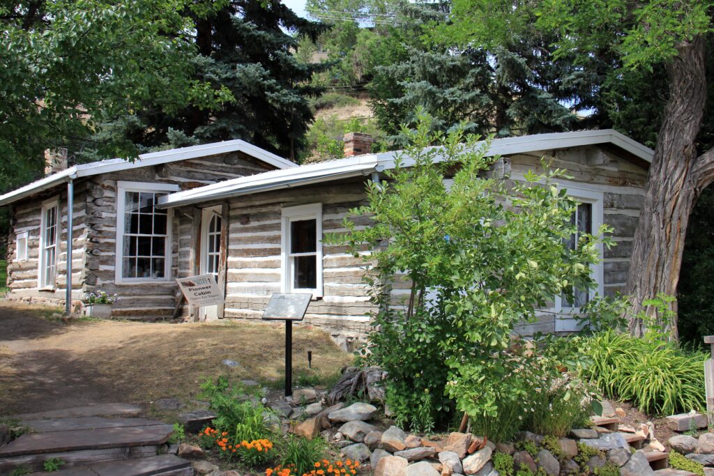
On the south side of the Last Chance Gulch is an old log cabin from 1864, so from the time of those first gold miners. Along Reeder’s Alley are several stone miners’ houses from the 1960s to the 1980s. And a little further is a wooden ‘fire tower’ from 1876, one of the five that still exist in the US. It’s these memories of pioneer history that you can find all over Montana and the other mountain states. In small ‘one horse towns’ with an old country store and saloon, in the names of motels, restaurants and shops and in the countless ‘historic sites’ that line the way and tell pieces of that pioneering history. A lot has changed since this part of the United States was the ‘wild west’, but it still adds to the character and atmosphere of the mountain states.
Cody
On Sunday I have a long drive planned: from Helena, Montana to Cody, Wyoming. The ride takes me to the fifth state I’m visiting this trip. I can’t say anything interesting about the ride, other than that it takes five hours and that I arrive in Cody by noon. Cody is known for two reasons: for the quintessentially American rodeo phenomenon (Cody immodestly calls itself the “rodeo capitol of the world”) and for its most famous resident and namesake: William F. Cody, better known as Buffalo Bill. Buffalo Bill was successively a cattle driver, rider on the Pony Express (which delivered mail in the area between the Mississippi and California), bison hunter and soldier. He enjoyed great fame (part fact, part fiction) and was arguably the first ‘celebrity’. His fame and his love for the ‘wild west’ led him to start ‘wild west shows’ and with that he had great success, also in Europe. His legend is kept alive at the Buffalo Bill Center of the West in Cody, where I spend an hour or so.

Monday is the Fourth of July, or Independence Day, and that national holiday is accompanied by parades and fireworks throughout the US. In downtown Cody, people have already set up seats all along Sheridan Avenue to claim a good spot (much like people in Amsterdam do on the eve of the King’s Day Vrijmarkt). Furthermore, Cody does not remind much of the old ‘wild west’; it is now primarily a tourist town and base for Yellowstone National Park.
I drive to Wapiti, between Cody and Yellowstone, where I spend the next night, and freshen up there for a while and then drive back. I have a ticket to the annual Cody Stampede Rodeo. For three evenings, several thousand rodeo enthusiasts gather in an arena of sorts on the outskirts of Cody to watch their rodeo heroes. This is my first real rodeo experience and I have to admit: it is quite a spectacle. The atmosphere is very special: the evening opens with the carrying in of a huge American flag and the singing of the national anthem. Then the presenter of the evening leads in prayer. Then follows an extensive and very patriotic tribute to the American troops, with the veterans present in the stadium standing up and some old veterans who enter the arena receiving a truly ovational round of applause. It is at the same time a goosebumps moment and a somewhat strange experience, because we – down-to-earth Dutchies – are not used to this kind of tribute. There is a broad, profound gratitude and great respect here for veterans, as well as for God, flag and country. It’s strange to be in the midst of it. I also have mixed feelings about the rodeo itself. It’s great what those cowboys and cowgirls can do, but I don’t like the animal cruelty aspect (I can’t imagine a calf likes it when a cowboy jumps on his neck…).
Yellowstone National Park
The road from Wapiti to Yellowstone National Park goes down the beautiful Wapiti Valley and takes me to the eastern entrance of the oldest national park in the United States. Yellowstone became the first national park in 1872 and at approximately 80 by 95 kilometers it is also the largest national park in the lower 48. More than three million people visit this park every year for beautiful mountain scenery, wildlife, geysers and hot springs. Yellowstone sits on a plateau resulting from a major volcanic eruption that occurred about 600,000 years ago. The resulting Yellowstone Caldera measures approximately 45 by 75 kilometers and contains the largest concentration of geysers and hot springs in the world. You will also find ‘mud pots’, hot springs that are so poisonous that they constantly turn the rock into bubbling mud.
Yellowstone National Park is huge, but thanks to the 8-shaped ring road, everything is easy to reach. Entering Yellowstone from the east side, I drive past Yellowstone Lake and then north down the Hayden Valley, in which the Yellowstone River flows. It is a wide, green valley, where bison roam here and there (in an hour I see more bison here than in the entire National Bison Range…). Here you will also find Mud Volcano (a ‘mud pot’), which smells strongly of sulfur, and Sulfur Couldron, also a very poisonous, bubbling pool.
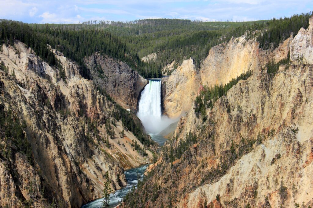
A little further, the Yellowstone River runs down a 450 to 1,200 meter wide and at its deepest point 356 meters deep gorge of yellow, orange and red cliffs: the Grand Canyon of the Yellowstone. At Artist’s Point you have a fantastic view over the gorge, the river below and a beautiful waterfall (the Lower Falls). Anyone with no photography experience can shoot the perfect picture here. You also have a beautiful view at Grand View on the north side of the gorge. I continue my way north, past Tower Fall and Calcite Springs to Mammoth Hot Springs. This is where liquid travertine comes to the surface, which then cools and hardens, creating bizarre rock formations. Bubbling pools and green and brown colored streams everywhere.
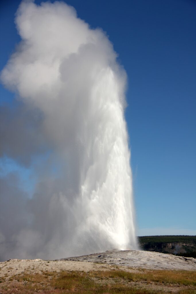
After a night of ‘car camping’ at Canyon Campground, on my second day in Yellowstone National Park, I go to see the western part of the park. I’m up early (it’s light at 5:30), so I’m at Old Faithful before the hordes of tourists. This geyser shoots boiling hot water thirty to fifty meters into the air at intervals of half an hour to two hours. Old Faithful permanently blows out steam and after waiting half an hour it starts bubbling and moments later the geyser shoots a huge amount of water and steam into the air. Very cool. The eruption lasts less than a minute and then the geyser returns to its ‘sleep mode’.
Geysers and hot springs are everywhere in this part of Yellowstone. Wherever you drive, you’ll see steam rising almost everywhere, a sign that geothermal activity is happening nearby. For example, just north of Old Faithful Black Sand Basin and the truly beautiful Sapphire Pool, which lives up to its name and is deep blue/sapphire. In some places there are concentrations of geysers and springs, but that’s only what you can see on the surface. Beneath the Earth’s crust, which is relatively thin here, must be an enormous amount of boiling water. That water finds a way out and that’s how geysers and sources are created. However, it is expected that the subterranean pressure will lead to another major eruption, the consequences of which cannot be estimated in advance.
The landscape around the geysers looks otherworldly in many places. Hardly anything grows, due to the high concentrations of sulfur, only algae thrive in the hot springs and give these springs their green, blue, brown and sometimes even yellow and red color. Everywhere you see bubbling holes in the ground and you can smell the sulphur. Sometimes you even walk through very sulfur-smelling clouds of steam – after a day of watching geysers, you also smell after sulfur yourself.
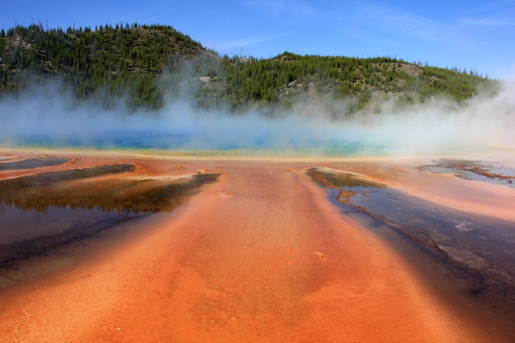
The Midway Geyser Basin is also such an otherworldly-looking place. The star here is the Grand Prismatic Spring, so named for its bright colors, from yellow and orange to blue. Unfortunately, the higher vantage point, from which you can see the Grand Prismatic Spring from above, is closed. I continue along Firehole Lake Drive, which is also home to several bubbling geysers and springs, and then into the Norris Geyser Basin, another large, toxic area with numerous dead trees among the geysers with names like Emerald Spring and Steamboat Geyser. Finally, I drive past Gibbon Falls to end my round again in Canyon Village.
Grand Teton National Park
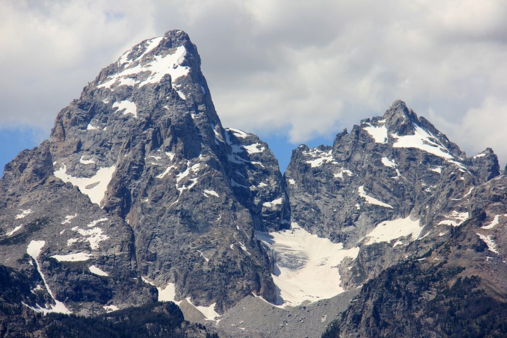
After a second night of car camping I visit West Thumb Geyser Basin, not the most impressive, but beautifully situated on the edge of Yellowstone Lake, and that concludes my stay in Yellowstone National Park. I leave the park on the south side and shortly after enter the last national park I visit this trip: Grand Teton National Park. The park’s name is derived from the French ‘grandes tétons’, meaning (excusez le mot) ‘big tits’, the name French-speaking trappers from Canada gave to the mountains here. The Teton Range, as these mountains are now officially called, is a mountain range that runs about eighty kilometers from north to south and is part of the Rocky Mountains. It is actually one long line of mountains, with twelve peaks, the highest of which, Grand Teton, is 4,260 meters high. Other peaks, such as Middle Teton (4,000 meters), Nez Perce (3,650 meters) and Mount Owen (4,000 meters) are not much lower than that.
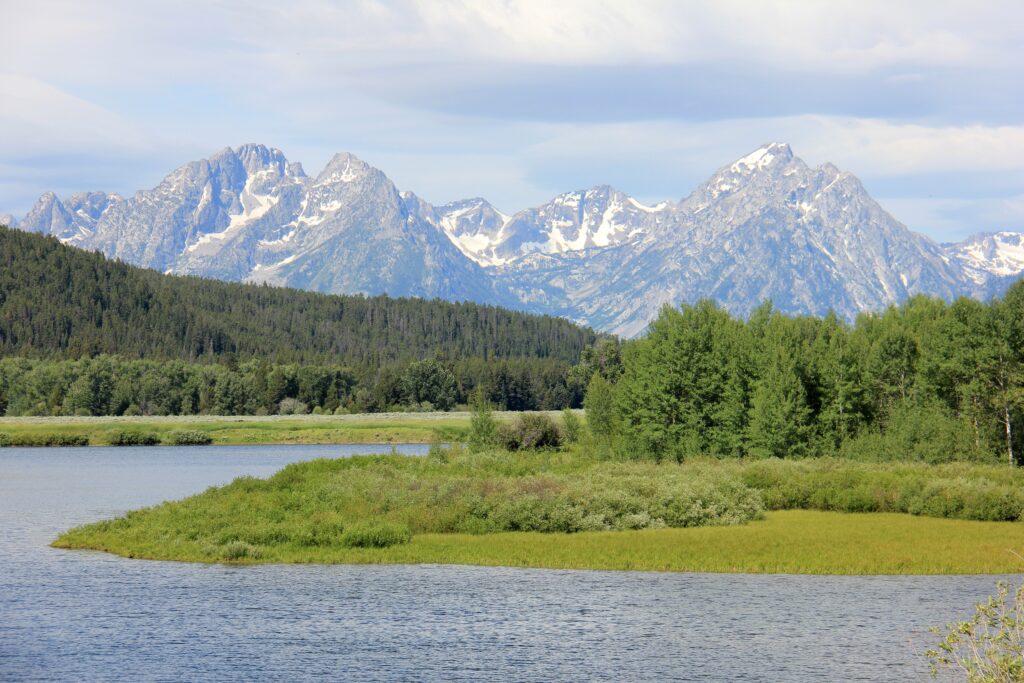
On the east side of this mountain range is a wide valley and at the foot of the mountains are a series of large and small lakes. There are lookout points everywhere, such as Jackson Lake Overlook and Willow Flats Overlook, from which you have a great view of the imposing mountains. Mighty granite mountains that rise steeply and tower over the flat valley. Oxbow Bend overlooks part of the valley and the Snake River. And from Signal Mountain you also have a panoramic view over the vast valley.
I drive the scenic drive around Jenny Lake (the Hidden Falls Trail is unfortunately closed for maintenance), Mount Moran Turnout, Mountain View Turnout and Cathedral Group Turnout. At every stop you have a new parnorame from a different angle, with the mountains always appearing bigger and more imposing. Glacier View is perhaps my favorite point, with a 180 degree view of the valley, with the row of highest peaks, with snow on the peaks, right in front of you. A magnificent view!
After spending the night in a log cabin at Headwaters Campground, it’s time to start the drive back to Denver, where I started this journey. I turn Thursday into a travel day: I drive in one go from Grand Teton National Park to Fort Collins, a town that is located half an hour north of Denver. Highway 198/191 runs through an unexciting hilly landscape, in my rear-view mirror the Teton Range slowly disappears from view. I make a stopover in Rock Springs (nothing worth mentioning here) and then continue via Interstate 89 to Fort Collins.
I spend Friday in Fort Collins. I drink coffee in the Old Town Square and shop in the local ‘mall’ and read for a while in the park near the library. Fort Collins turns out to be a very nice college town. Unlike many other places in the US (see my comment about Helena earlier in this travelogue), Fort Collins has a nice downtown, where old buildings from the late nineteenth and early twentieth centuries have been refurbished and where you will find cafes, restaurants and small shops. After a relaxing day in Fort Collins, it’s time to drive back to Denver Airport on Saturday. Which brings an end to a wonderful journey in a very beautiful part of the United States.