Pacific Northwest, USA
Itinerary: Seattle – Boeing Factory – Yakima Valley – Columbia River Gorge – Mount Hood – Crater Lake National Park – Willamette Valley – Portland – Mount Saint Helens – Mount Rainier National Park – Olympic National Park
Seattle
After a flight of almost ten hours, I land at Seattle-Tacoma International Airport late in the morning, local time. For the next two weeks I will be doing a road trip in the states of Washington and Oregon, in the northwestern United States. Called the Pacific Northwest, this region is known for its liberal political climate, laid-back atmosphere, nature that offers endless opportunities for outdoor activities, viticulture (Washington is the second largest wine producer in the USA, after California) and of course coffee culture, thanks in part to Starbucks, the coffee chain that started in Seattle in 1971.
Passport control and baggage handling are quick and smooth and then I take the light rail into the city. Seattle is the largest city in the Pacific Northwest with 660,000 inhabitants, which is smaller than Amsterdam and certainly not large by American standards (Washington and Oregon together have about eleven million inhabitants, only 3.5% of the total number of inhabitants in the USA). The studio I arranged with Airbnb is within walking distance of Westlake Station in Belltown, a neighborhood with many apartments, coffee shops, cafes and restaurants. And two blocks from the Space Needle, the icon of Seattle. The futuristic-looking tower with a kind of flying saucer on top was built in 1962 on the occasion of the World Exhibition that year.

Seattle is known for its changeable weather (a ‘Dutch’ climate), but on my first (afternoon) day in the city the weather is nice. I walk past the Space Needle and then to the Olympic Sculpture Park. This modern park, which the municipality developed in 2007 together with the Seattle Art Museum, contains several statues and sculptures. In addition, the park offers beautiful views over the Puget Sound, the water on which Seattle is located, with the mountains of Olympic National Park in the distance. That’s where I will end this journey in two weeks time.
After my walk I sit down on the terrace of a cafe around the corner from my lodging address to have something to eat and drink. The time difference with the Netherlands is nine hours, so I go to bed on time to get used to it as quickly as possible. As a result, I wake up early the next morning. I have breakfast downtown at one of the many local Starbucks branches and then I walk towards the waterfront. That’s where Pike Place Market is located. Since 1907, fresh vegetables, fish, meat, flowers, but also all kinds of organic products and the like have been sold here in the old market halls and galleries. There are also several shops. The large neon Public Market Sign is as symbolic of Seattle as the Space Needle. The very first Starbucks is also located at Pike Place Market. “Fresh coffee, tea and herbs” says the original logo with the famous mermaid, which still hangs there. The Original Starbucks is now popular with tourists: there is a long queue outside the door every day.
In the afternoon, I walk down 4th Avenue, past the Central Library—a large, modern, glass building from 2004, designed by Dutch architect Rem Koolhaas—to the Pioneer Square Historical District. In this part of Seattle, most of the buildings date from the late 1800s. From 1889, the mainly red brick buildings with cast iron fire escapes replaced the old wooden buildings that had been destroyed during a major fire that year. You will find modern coffee shops next to old bars and saloons. And the white Smith Tower, built in 1914. It has 42 stories, which was high for the time.

Today, of course, there are taller towers in downtown Seattle, including the Columbia Center, which I go to on Sunday morning. From the 73rd floor you have a fantastic view of Seattle and the surrounding area. It’s Seattle’s tallest building, so you have an unobstructed view: Chinatown, the harbor, and the stadium to the south, to the east Interstate 5, which runs from Seattle along the US east coast to San Diego, and the beginning of Interstate 9, which runs across the USA to Boston on the east coast. And to the north downtown, Belltown and yes: the Space Needle! Sunday afternoon I head to the Capitol Hill area, where I spend some time in the huge Elliott Bay Book Store and relax and enjoy the beautiful weather in Cal Anderson Park.
After two days in Seattle, on Monday morning it’s time to pick up my rental car. I leave the city in a northerly direction, to the town of Mukilteo, about half an hour away. This is where the aircraft manufacturer Boeing’s factory is located and I signed up for a tour. For security reasons, nothing is allowed inside: no bags, no telephones and (unfortunately) no photo cameras. The factory – a huge hangar, the largest building in the world by volume – produces the models 747, 767, 777 and 787. In 2017, Boeing built 760 aircraft here, which cost between 250 million (787) and 400 million (747) dollars each (!) for interested parties. In the factory, several aircraft are being worked on at the same time and as a visitor you can look down from a high balcony on the gigantic work floor where the aircraft are assembled. Fascinating to watch!
Over the Cascades to Yakima
After the Boeing tour, I drive east and after about an hour I drive into the mountains of the Cascade Range, the mountain range that runs from north to south through the states of Washington and Oregon and ensures that the rain that comes from the Pacific is alleged in the western part of these states. I’m staying at Snoqualme Pass with the intention of going to Alpine Lakes Wilderness the next day and to Mount Rainier National Park the next day. But when it starts to rain a little later and I look at the forecast for the next two days, it look like I better adjust my scedule. Mount Rainier has to wait a little longer and instead the next morning I drive to Yakima. As soon as I leave the Cascades on the east side, the clouds disappear and the rain gives way to the sun.

On this side of the mountain range, there is very little rain and you can see that right away: the area is much drier. The US90 goes through rolling grassland, the grass is golden yellow and here and there is a farm. The US82 to the south runs through a very dry hilly landscape (which wouldn’t look out of place in Arizona much further south), until after an hour and a half I drive into the Yakima Valley. It is greener here, but here too there is not much rain, which makes the Yakima Valley very suitable for viticulture.
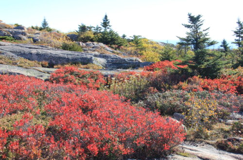
The valley is divided into several AVAs (American Viniculture Areas): the Yakima Area, the Rattlesnake Area, the Prosser Area and the Red Mountain Area. I first visit the Rattlesnake Area, where the vineyards sit on rolling hills with beautiful views of the area and the dry, barren foothills of the Cascades in the background. The soil is bone dry and that is why you see irrigation systems running along the vines everywhere. The red grapes have already been harvested, the white grapes are still there, but that won’t be long.

After the Rattlesnake Area I also drive through the Yakima Area. In total there are about eighty wineries in the Yakima Wine Valley, mostly small family businesses. Apparently the climate is not only suitable for viticulture, because I also see a lot of apple orchards. In the vineyards I see everything from cabernet to merlot to malbec, and from chardonnay to pinot gris to riesling. Everything seems to grow here. I’m by car, so I’ll save wine tasting until I get back to Yakima, a little sleepy town. At Gilbert Cellers in downtown Yakima I am served some delicious wines. Luckily I can walk back to my motel.
Columbia River Gorge and Mount Hood
Highway 97 takes me to the Columbia River, which forms the border between Washington and Oregon, on Wednesday mornings. The weather is changeable, with showers and short clear spells alternating. Today I visit the Columbia River Gorge, a destination I had a different idea about beforehand. Given the name, I expected a river that flows down a (narrow) gorge, but the Columbia River turns out to be a brother of the Maas River in the Netherlands: a wide river, along which a highway runs. Back in 1915, the old US30, a two-lane highway, was the first tarmac road in the Pacific Northwest and the first scenic byway in the US, but with the two-lane US84 next to it, I think it’s a little less scenic…

The Columbia River is therefore not the main reason why this is a National Scenic Area. That is the vast nature reserve on the south side of the river. There was a major wildfire here in 2016 (because a teenager set off fireworks) and since then large parts of the nature reserve have been closed. So are many hiking trails to waterfalls, but a few spots have since reopened, such as the Herman Creek Trail. It is a walk of about an hour, through a piece of forest where you can still see the effects of the fire two years ago, but where nature is visibly recovering at the same time. Nice to see that the blackened trees are now surrounded by new greenery.
After the hike I drive to Multnomah Falls, the second highest waterfall in the United States. The waterfall is beautiful and with Benson Bridge in front of it very photogenic, but it is also very busy. At the western end of the Columbia River Gorge I visit Crown Point, a high point with panoramic views. Dark clouds hang menacingly over the Columbia River.

After spending the night in Gresham, on Thursday I head to Mount Hood National Forest, a large area of forests surrounding the 3,400-meter-high Mount Hood in the Central Cascades. You can take various walks here. I first walk the trail to Mirror Lake, a modest walk in terms of distance, but because the path goes up the mountain, it is quite a brisk walk. On a clear day, Mount Hood reflects in the water of Mirror Lake, but it’s cloudy this morning, so there’s little to reflect. It is wonderfully quiet there. I walk around the lake and then back again.
After getting coffee, I drive to Lost Lake, which is on the northwest side of Mount Hood. The road to Lost Lake appears to be closed, so I follow the signs ‘detour’. The alternate route is one lane, barely maintained and I don’t see anyone else. At a certain point the road continues unpaved, which is always the moment that you think: “What the f* am I doing?!” The route is very beautiful though, over the mountains and despite the clouds I catch a glimpse of Mount Hood on the way . Clouds and sun alternate at a rapid pace, so it won’t be more than a glimpse. After a while I actually drive on asphalt again. A glance at the map reveals that I drove on the Lolo Pass Road. Lost Lake at least has an appropriate name. It is also very quiet here. The walk of five kilometers around the lake is flat, so doable.
Crater Lake and Willamette Valley
When I drive south in the late afternoon and leave the Cascades behind, the difference in the weather is immediately noticeable: the clouds continue to hang around the mountains and the sun is shining here. In this part of Oregon, the dry grass turns a golden yellow and farmers spray their land.
I stay overnight in Bend and the next morning drive on to Crater Lake National Park, all the way in southern Oregon. What is now Crater Lake – as the name suggests: a large crater lake – was once Mount Mazama, a large volcano about 3,600 meters high. According to geologists, Mount Mazama erupted about 7,700 years ago, imploding the volcano. The deepest lake in the US subsequently formed in the collapsed crater. The lake does not fill the crater to the brim, making it appear as if the water is surrounded by mountains all around. There is a road on the crater rim with various viewpoints, where you have a beautiful view over the clear blue water. Incidentally, this is only possible four months a year, from June to September. During the other eight months, this entire area is covered with a thick layer of snow. I think it’s a very nice place, well worth the (somewhat) detour.

It’s Saturday morning as I drive to the Willamette Valley. Named after the river of the same name, the valley lies roughly between Salem and Portland. In the valley and on the surrounding Eola-Amity Hills you will find dozens of vineyards. Unlike the Yakima Valley in Washington, which has just about every known grape variety, the Willamette Valley is mostly about pinot noir (and a bit of pinot gris and chardonnay). The Willamette Valley has a mild climate, is slightly cooler than the Yakima Valley and receives slightly more rainfall. Where in the Yakima Valley the red grapes had already been harvested and the white grapes not yet, here it takes a while before the grapes are ripe. A winegrower with whom I have a chat is therefore a little concerned about the forecast that says it’s going to rain. After lunch in McMinnville, I will of course do some wine tasting. I’m not a fan of piot noir, but in this environment you can’t escape the fact that especially pinot noir is served during a tasting. Even after today I am not a fan of this grape…
Portland
Although Salem is the capital, Portland is Oregon’s most famous city. I spend the night in a suburb and take the light rail to the city from there. That light rail leaves next to my motel and is in downtown Portland in twenty minutes. I take it easy, drink coffee, browse a huge bookstore and then I walk about ‘old town’, unsurprisingly the oldest part of Portland. Most of the buildings here date from the late nineteenth and early twentieth centuries. Later, this neighborhood developed into Chinatown, creating a bit of a strange contrast between the historic buildings and the Chinese lanterns and street signs (Chinatown has already moved somewhere else and the neighborhood is a bit run down). It strikes me that there are a lot of homeless people on the street. I’d noticed the homeless in Seattle, but here in Portland it’s even worse. In every street there is one, or sometimes a group, I even see dome tents on the street in some places where people sleep.

The Willamette River (the one from the valley) runs right through Portland, and at least eight bridges connect west Portland to east Portland. The Tom McCall Waterfront Park has been created along the west bank of the river. Trees, grass and a riverside walkway are located where a highway used to run. On the north side of the park is the Saturday Market every weekend, which strangely enough takes place on Saturday and Sunday. Portland is known for its food trucks. In the Netherlands we now know food truck festivals mainly in summer, but here they are permanent, especially on street corners and on vacant lots, such as on the corner of Washington Street and 9th Avenue. Do as the locals do, so that’s where I get my food.
Pioneer Square is the main square of downtown Portland. To one side is the Pioneer Courthouse, dating from 1875. Not only here and in the ‘old town’ district, but all over Portland are many old buildings. And unlike in ‘old town’ they look very good. There is also a lot of modern new construction in between, but the old buildings do give the city a nice atmosphere. Just like the street art I encounter in different places. The city’s unofficial slogan is “Keep Portland weird” and that’s apt. The mix of historic buildings, street art, food trucks, coffee shops, microbreweries and wine bars gives the city its own character.
After finishing my first day in Portland at a wine bar (the prices of wine in the USA do encourage modest drinking…), I take it easy on the second day. I go to a shopping center and then to Washington Park, a large park in the western part of Portland, which includes the Portland Zoo, a botanical garden, and a Japanese garden. But you can also just walk through the park and enjoy the sun in the grass or on a bench with a book.

Mount Saint Helens and Mount Rainier
It’s Tuesday morning when I leave Portland and drive to Mount Saint Helens in two hours. The first part is still on a boring highway, after that a two-lane road meanders between the hills and mountains. Yes, we are back in the Cascades! The weather is beautiful and from the various vantage points you have a beautiful view of Mount Saint Helens and the surrounding area. At one of the lookout points, a narrow path runs along the mountainside. There is no one there, except for the crickets it is quiet and you have a beautiful view of the volcano and the valley. In short: a perfect place for lunch.
Mount Saint Helens is ‘only’ 2,500 meters high, but forty years ago the volcano was still 400 meters higher. In 1980, during a major eruption, the entire top of the volcano, especially the north side, was completely blown away. Large amounts of lava and rock ended up in the area, which is now a National Monument. Nature has now largely recovered and on the north side you can see the new crater well, just like the old lava flows in the valley.
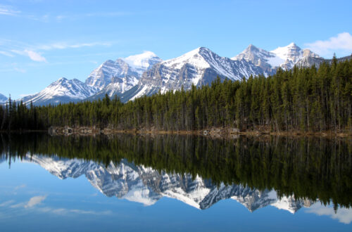
After I stop at Coldwater Lake on the way back, it is still about 2.5 hours to Ashford. Different landscapes alternate: first green mountain slopes, then an almost flat valley with a farm here and there, and then coniferous forests that seem to be mainly intended for logging. At the end of the afternoon I arrive at my motel, literally next to the entrance to Mount Rainier National Park. At 4,400 meters, Mount Rainier is the fifth highest mountain of the ‘lower 48’ and because the surrounding mountains are all much lower, it rises solitary above everything, which makes it even more impressive than its height suggests. Mount Rainier is also a volcano, but it last erupted in the nineteenth century.

The next morning I drive into the park. The road to Mount Rainier is already beautiful: the two-lane road meanders up through the pine forests. It’s cloudy and I try to catch a glimpse of the mountain through the trees and clouds, but I see nothing but clouds. At one point – the road continues to climb – I even drive into the clouds. But after a few hairpin bends I suddenly rise above the clouds. Suddenly the sky is a clear blue and after another bend it suddenly looms in front of me: the mighty Mount Rainier. It’s the “Oh wow!” moment of this trip!
At Paradise (just follow the signs, you’ll get there automatically) I start my walk. The Skyline / Golden Gate Trail is four miles long and that doesn’t seem like much, but on the way you bridge a height difference of 520 meters and that makes it a tough walk. But also a very nice one! The path climbs quite steeply from the start, you get a little closer to Mount Rainier and you have a different view every time. The Nisqually Glacier is clearly visible. In the valley the clouds hang like a white blanket between the mountains, a surreal, slightly mystical view from above. Along the way I come across squirrels and huge marmots and as I get higher the vegetation on the mountain slopes changes. After an hour’s walk I arrive at Panorama Point, where you have a panoramic view (duh…) and in the distance you can see Mount Baker, Mount Hood (in the clouds) and Mount Saint Helens. The trail continues uphill, above the tree line, where a sub-alpine climate prevails. Here are still remnants of snow (from last winter, remember I am here in September), yet it is not cold, thanks to the sun I do not even have to wear a coat.

Down the valley I walk back to the starting point. The clouds that still hung in the valley at the start of my walk have now lifted and now hang around Mount Rainier, which is again hidden from view. I was very lucky this morning to see Mount Rainier in all its glory! It is a fantastic walk, really very beautiful. All in all, Mount Rainier National Park is the highlight of the trip. After three hours of walking I am back at the start and very satisfied.
Olympic National Park
I end my journey in the Pacific Northwest on the Olympic Peninsula, the large peninsula, roughly between Seattle and the Pacific Ocean. There is a lot of rain here (supplied by the ocean), making it a very green area with forests, mountains and lakes. Highway 101 runs along the edge around the peninsula, otherwise there are few roads and the majority of the peninsula is inaccessible wilderness. Since 1938 this is a protected nature reserve: the Olympic National Park.
After driving all morning I arrive at the Olympic Peninsula. I stop at Ruby Beach, because of course you can’t do a road trip in the Pacific Northwest without actually seeing the Pacific. It’s not exactly beach weather (cloudy and cool), but I walk along the beach for a while. Off the coast are a number of large rocks in the water and on the beach are large numbers of graying tree trunks, victims of a westerly storm and high water.

The western part of Olympic National Park is also the wettest and is home to the Hoh Rain Forest. Yes, a rainforest in the USA! I don’t get to see much of this rainforest, because the road to the visitor center (where hiking trails also start) appears to be closed. You can’t do more than the ‘scenic drive’, but that gives you a bit of an impression of the densely wooded area, with large trees that are covered with moss. In the afternoon it starts to rain (it’s not called rain forest for nothing…) and it continues to do so that day. I spend the night in Forks, get groceries and spend the rest of the afternoon reading and relaxing.
The next day is already the last day of my road trip. First I drive to Crescent Lake. This large lake was carved out by glaciers thousands of years ago. I walk along the lake and through a beautiful piece of forest, with ferns and cedar trees that are hundreds of years old and that (here too) are covered with moss. I also walk past Marymere Fall, a small waterfall, deep in the forest. After an hour and a half of walking I continue to Hurricane Ridge. The road winds up and the view gets wider and wider. Once at the top you have a panoramic view of seemingly endless pine forests and the mountains of the Olympic Mountains fill the horizon. It is mostly cloudy and there is a strong, cold wind at this altitude.
In the afternoon I drive to Tacoma, a half hour drive from the airport, where the next day I return the car and leave for the Netherlands again. My road trip in the Pacific Northwest is already over. A relaxed trip, of which I will especially remember Crater Lake and Mount Rainier as highlights.