Guatemala, Honduras & Belize
Itinerary: Antigua – Lago Atitlán – Chichicastenango – Copán – Flores – Tikal – San Ignacio – Xunantunich – San Pedro – Caye Caulker
Antigua
In the Netherlands, winter hasn’t given up yet and spring has yet to arrive, so it’s a good time to travel. My destination this time: Central America. Guatemala, Honduras and Belize to be precise. One trip, three countries. I fly with a layover in Atlanta (USA), in total about sixteen hours. But that almost gets a lot more when the pilot aborts the take-off at Atlanta. Apparently there is a problem with the plane. It takes a while and then the announcement comes: “We have solved the problem… We hope…”, after which we leave.
We land at a quarter to eight in the evening local time at the airport of Guatemala City. My luggage has also come along and I go through customs in no time. In the hall of the airport I buy a ticket for the shuttle to Antigua. I will be using this kind of shuttles (minibuses) for almost the entire trip. An hour later I am dropped off at the central square in Antigua, from where it is only a short walk to my hotel. It is now 10 p.m. local time, 5 a.m. in the Netherlands, so I immediately go to bed.
Mayan tribes lived in what is now Guatemala three to four thousand years ago. The height of Mayan culture coincided with the first half of what is known in the West as the Middle Ages. Mayan cities such as Tikal, but also Calakmul in Mexico and Copán in Honduras date from that time. These were important political, religious and commercial centers, with large temples and pyramids surrounding plazas. In 1521, the Spaniards invaded the area, subjugated the Maya (in fact, an entire population was enslaved) while converting them to Catholicism.
In 1821, an uprising led to independence, but the situation did not get much better for the Maya. Instead of the Spanish king, the wealthy landowners were now in charge. After a number of dictatorial regimes, the 1970s and 1980s were dominated by political violence by guerrilla movements and intervention (supported by the USA) by the Guatemalan army. Tens of thousands of people died. A peace agreement was signed in 1996. Meanwhile, Guatemala is slowly improving, but poverty, corruption, crime and political scandals are still very much part of Guatemala today.

Guatemala is slightly larger than England and has almost 15 million inhabitants. More than half of them live below the poverty line. 40% is Maya, 60% is Mestizo (mixed Maya/Spanish). Guatemala City is Guatemala’s only real city (one-fifth of all Guatemalans live there) and is notorious for its crime rate. That is also the reason that I immediately travel to Antigua upon arrival – there is little reason for visitors to stay in the capital. The capital stands in stark contrast to the rest of the country, where the villages dominate the Mayan culture, women wear traditional clothes and one of the many local dialects is spoken (the official language in Guatemala is Spanish, but for Guatemalans that is their second language).
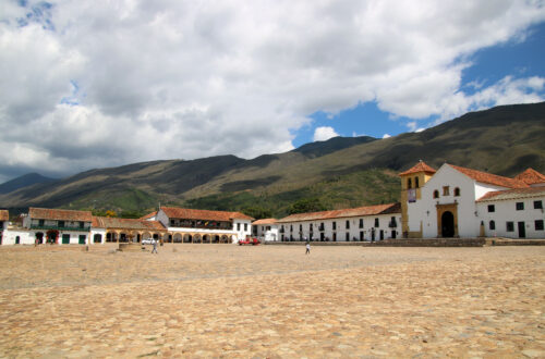
So my journey starts in Antigua. On the first morning there I go for breakfast at a small restaurant near my hotel. On the roof terrace, in the sun, with a desayuno típico (a traditional local breakfast) and coffee. A perfect start to the day. Antigua is a small city with about 35,000 inhabitants and the historic center is easily walkable. The center consists of cobbled streets and low-rise buildings with colored facades and looks very picturesque. The central point is Parque Central, the main square with trees, benches and a fountain in the middle, as you will find in almost every Latin American town and city. The square functions as a social meeting place for locals, a landmark for tourists and a sales point for (of course) the saleswomen.
The square is surrounded by colonial buildings. On the south side is the Palacio de los Capitanes Generales from 1549, which was once the headquarters of the Spanish colonial rulers for all of Central America. To the east of the square is the Catedral de Santiago, or rather just its facade, as the rest of the original cathedral was destroyed in a massive earthquake in 1776. On the north side of the square is the Palacio del Ayuntamiento, or Antigua’s City Hall. From the balcony on the first floor you have a nice view over the square, with the top of the volcano Agua in the background.

If you walk north from the square, you’ll come to the Arco de Santa Catalina, an arch over the street, which was once part of a seventeenth-century convent. The arch is on almost every promotional photo of Antigua. A little further on is the Iglesia y Convento de Nuestra Señora de la Merced, a large yellow building with white trim (it could be a sugar cake) that – unlike the cathedral – has survived every earthquake so far. It seems to be the only one, because only the ruins of the Iglesia del Carmen and the Compañía de Jésus have survived. (Normally I tend to ignore churches, but in the quintessentially Catholic Latin America there is no escaping them.)
The weather is lovely, partly cloudy and about 25 degrees. It is pleasantly busy on the street and the people are very friendly. They say hello or smile and the atmosphere is very pleasant. Tuk-tuks, motorcycles and rattling cars drive in the streets, which – unlike the tuk-tuks – drive at walking pace over the very uneven cobblestone streets. I have lunch in the courtyard of one of the restaurants on the square and take the time to relax. In the afternoon I walk another round and at the end of the afternoon I have dinner at a small Mexican restaurant. Mojitos and tortillas as it slowly gets dark outside.

During my second day in Antigua I take it easy. After breakfast – on the same roof terrace – I walk down the local market, where everything is sold, from clothing to electronics and from household items to fruit and vegetables. Right next to the market is the ‘bus station’ (not much more than a sandy plain), where the ‘chicken busses’ drive back and forth. Chicken busses (so called because people also take their chickens and other animals in them) are old school buses from the United States, often painted in cheerful colors. They drive everywhere and stop everywhere and for everyone, until no additional passengers can be squeezed in anymore.
I adjust to the Latin American pace and sit down for a while with a cup of coffee on a bench in the Parque Central. After lunch I walk to the Cerro de la Cruz, a hill on the north side of Antigua, from where you have a fantastic view over the city. Antigua is located in a valley between three volcanoes: Volcán Agua (which is a bit of a weird name for a volcano, since agua means water), Volcán Acatenango and Volcán Fuego. In the background, the Agua towers over the city. If this volcano ever erupts again, Antigua will be doomed. I spend an hour here to enjoy the view and the beautiful weather.
At the end of the afternoon I go to a small wine bar, next to the Arco de Santa Catalina, where they have a special concept: the first glass of wine costs 35 quetzales, the second 30, the third 25 and the fourth 20. The more you drink, the cheaper your wine becomes. Brilliant concept! The wine bar is very small and the two waitresses – both young girls from Germany – have plenty of time to chat with their guests and exchange (travel) experiences. It typifies the open and friendly atmosphere in Antigua.
Lago Atitlán
After two days in Antigua, a shuttle bus takes me to Panajachel in 2.5 hours. The western part of Guatemala consists of highlands and here you will find the highest mountains in Central America, including many volcanoes. In addition to volcanic eruptions, Guatemala is regularly hit by earthquakes: In 1776, 1917, 1918 and 1976, devastating earthquakes took place.
Because the area is hilly and the shuttle bus sometimes has some trouble with that, the driver has turned off the air conditioning, which makes it quite a hot ride. At eleven we are in Panajachel, which is located on the north side of Lago Atitlán, a large lake that was created by volcanic eruptions 85,000 years ago. It is a very touristy village, where you are constantly approached by men who offer you a boat (“Barco! Barco!” No, I don’t want a boat!) and where stalls with local souvenirs are teeming. The tuktuks drive down the streets at lightning speed. But the beautiful location on Lago Atitlán makes up for it all. The lake is surrounded by hills and three unmissable volcanoes: Volcán San Pedro, Volcán Toliman and Volcán Atitlán. There are many restaurants on the lakeside, where you can enjoy a delicious meal with a view over the lake.

The next morning I wake up early and walk to the shore of the lake. It is a clear morning and still quite calm, a good time to take pictures of the lake, the volcanoes in the background and the wooden jetties in the foreground. After breakfast I go for a boat trip along the various villages around the lake. We first sail to San Marcos La Laguna, a small village that is especially popular with hippies and lovers of yoga and organic food. The second village we visit is San Juan La Laguna, a more authentic village, where people are proud of the local culture, as witnessed by the many wall paintings in the village, which depict, among other things, weavers and the cultivation of coffee. There is a small market and many women walk in traditional clothes.
San Pedro La Laguna is again a lot more touristy, especially the part around the jetties. A little further up the hill, local life takes place. The last village we visit is Santiago Atitlán. Santiago is bigger than the other villages and here too the streets around the jetties are mainly aimed at tourists. Tuktuks drive back and forth and a single chicken bus and pickup (with the passengers in the cargo box) also makes its way down the streets. Away from the beaten track, I find a quiet street that ends at water. Ashore are small wooden boats that are used by fishermen and that are still made by hand in the traditional way.

Every Sunday in Chichicastenango (Chichi), an hour and a half north of Panajachel, a large market takes place. Residents of surrounding villages come to Chichi to sell their vegetables, fruits, meat and other products. The market takes place on the central square, but that square is so crammed with stalls and equipped with a corrugated iron roof that you no longer recognize it as a square. The surrounding streets are also completely taken up by the market and partly the market is aimed at tourists. It’s a very busy place. Locals and tourists make their way down the narrow paths. It is a maze of corridors, where you quickly lose your sense of direction.
Almost all women and girls here wear traditional clothes. On the north side of the square is the Centro Commercial San Tomás, a hall completely filled with stalls selling fruit and vegetables. From the gallery on the first floor you have a nice view of the trade below. Part of the market is also furnished with food stalls, where women prepare food in large pans and their daughters make tortillas (the small round pancakes that you get with many dishes in Guatemala).
At the end of the morning I escape the crowds in a restaurant, where I have lunch and spend some time before I take a shuttle to Guatemala City in the afternoon. There is initially some confusion among the men of the shuttle buses about which shuttle I should take. The outcome of the discussion is that I first have to take the shuttle to Antigua and then transfer to a shuttle to Guatemala City. The drive to Antigua takes longer than planned, due to the heavy traffic, and the driver tells us on the way that the center of Antigua is closed to traffic due to some procession. We are dropped off at the edge of the center and for a long time it is unclear where I can find the connection to Guatemala City. In the end, it turns out that a shuttle to Guatemala City leaves at seven o’clock from the other side of the center. This ride also takes longer than planned (you don’t expect traffic jams here in the evening…), but at 9 p.m. I finally arrive at my hotel in the Guatemalan capital, the city that I only use as a ‘hub’.
Copán
Sometimes you have to get up very early during a trip, even if it is your vacation. For example, if you want to go from Guatemala City to Copán, just across the border in Honduras. The bus that goes there leaves at 4:30 a.m. and you have to be there well in advance, so get up early. But then you ride to your destination in five hours by comfortable coach. The fact that Guatemala City is not such a safe city is further underlined by the armed security guard who accompanies us the first part of the ride (the part that we drive in the dark). When the sun is up, we drive through a hilly landscape that looks quite dry, with the occasional village, some agriculture and here and there some cows. The border area with Honduras is a bit more mountainous, but all in all the area is not very special. At half past nine we are at the border of Guatemala and Honduras. The customs formalities take little time and after that it is only a ten kilometer drive to Copán.

Copán turns out to be a very nice place. The cobbled streets with white plastered houses with red roof tiles look picturesque and there is a pleasant central square, where women and daughters sit on benches. Tough men wear light-colored cowboy hats. It is a compact village and there is a very relaxed atmosphere. It is also much less touristy than, for example, Antigua. And while we are comparing: it is also a lot warmer in Copán: in Guatemala the average temperature was about 25 degrees, in Copán the temperature is well above thirty degrees…
After I’ve walked about the town, I find a cafe annex hostel where you can have lunch outside on the veranda (lunch here is so good that I’ll come back a few times). The posada where I am staying has its own relaxation area that I will use a few times: an attractively furnished roof terrace, where you can enjoy a fresh frappuccino or another drink with a view of the roofs and the surrounding hills.

In the classical Maya period Copán was one of the most important Maya cities in Central America. Successive Mayan kings continued to expand the city. The population probably grew so fast that raw materials became exhausted. Deforestation and flooding probably also played a role in the demise of ancient Copán, which was completely abandoned around the year 1200. The ruins of the ancient city are located a mile outside present-day Copán. Here you will find the Gran Plaza, which was surrounded by various temple buildings and where you can still find a number of stone burial columns with images of Mayan kings and other figures.
The Esclinata de los Jeroglífos is a stone staircase built in the eighth century, decorated from top to bottom with hieroglyphs that, as far as is known, depict the history of the royal family of Copán. Via a number of stairs you reach the top of the Templo de las Inscriptiones, where you have a great view. The temple, together with the Patio Oriental and the Patio Occidental and the buildings around it, formed the Acrópolis, which was only accessible to the elite. Archaeologists have found that the ruins of the buildings you see now have been built over previous buildings, sometimes as many as three or four times over, getting bigger and more beautiful.

At the end of the morning I am back in modern Copán where I relax for the rest of the day. The next morning, Wednesday, is still dominated by relaxation (a little reading, a little eating) and in the course of the afternoon I make my way to the bus that will take me back to Guatemala. The bus leaves an hour and a half later than planned (no idea why) and we eventually arrive in Guatemala City two hours later than planned.
Flores and Tikal
You can travel from Guatemala City to Flores by bus. Then it will take you (at least) twelve hours. You can also fly there in an hour. I don’t think that’s a difficult choice. We fly with a small propeller plane that only fits eighteen people. Not super comfortable, but because the plane doesn’t fly that high, you do have a nice view. We land at the small airport of Santa Helena (one runway and a small departure and arrival hall) and from there it is only a short drive to Flores.

Flores is located on an island in the Lago de Petén Itzá and is connected to the mainland by a road. It’s a small, picturesque town, with cobbled streets and pastel-colored houses. Here too the people are friendly and here too it is sunny and above thirty degrees. All the streets of the almost perfectly round island lead up to the higher central square with a white church. A pedestrian promenade, malecón, has been constructed around the village. But the rising water level of the lake has flooded about a third of it. On the west side of the malecón are a number of cafe/restaurants with verandas, where you can eat and drink cocktails with a view of the lake. I sit there for a few hours while the sun slowly sets. Life is tough…
The next morning I take a shuttle bus to go to Tikal. The driver takes a quite detour: First pick up someone at a hotel in Santa Helena, then two people at the airport, back to Flores, again to the airport (?), refuel and then we finally drive to Tikal. Which is still quite a drive. The north of Guatemala is less elevated and dominated by rainforest. The ruins of Tikal are spread over a large area, in the middle of that dense jungle. Maya settled here about 700 BCE, but the ruins you see today date back to the seventh and eighth centuries, when Tikal’s power was at its peak. Most famous are the high, steep pyramids at the Gran Plaza. This steep architectural style is typical of Tikal and you will not find it in Mexico or elsewhere in Guatemala, for example. Like the Egyptians, the pyramids of the Maya were burial monuments for the kings, who were buried under the pyramid.

The highest and most beautiful, Templo del Gran Jaguar, stands on one side of the Gran Plaza and is not allowed to climb, Templo del Mascaras on the other side is allowed and from above you have an impressive view over the ruins. Between the pyramids on the north side of the Gran Plaza are the ruins of the Acrópolis del Norte, which are much older than the two great pyramids. Some buildings probably date from the time when the Maya had just settled in Tikal. The Acrópolis probably consisted of twelve different temples.
There are more tourists here than in Copán, but it is not nearly as massive as in Mexico and people disperse because the area is so large. Via walking trails through the jungle you can walk to other groups of ruins, such as the beautiful Templo 5 (with rounded corners and only partly excavated and restored), the ruins of Mundo Perdido (a pyramid with various buildings around it) and the Plaza de Siete templos. Finally I get to Templo 4, hidden deep in the jungle. Templo 4 is the second tallest pre-Columbian structure in the Americas, 64 meters high. You can also climb this pyramid, dating from the eighth century, and on top you can look for miles over the treetops. A little further on, the peaks of the Templo del Gran Jaguar and the Templo del Mascaras Templo 5 and Mundio Perdido also rise above the trees. A beautiful (and sweltering hot, in full sun) spot.

The next morning is relaxed with breakfast at the malecón and with a book on the veranda of the posada. Around noon I let one of the many boats on the waterfront take me over to San Miguel, on the other side of the lagoon. It is only a short boat ride and then another twenty minutes walk to a beach on the lake. A great place to spend an afternoon. In the evening I look for another restaurant on the malecón of Flores for dinner.
San Ignacio and Xunantunich
After two weeks in Guatemala and Honduras it is time to go to the third country of this trip: Belize. Belize is a small country, east of Guatemala, on the Caribbean Sea. In what in the West is called the late Middle Ages, the Maya kings of Caracol and Xunantunich ruled here. The Mayan ruins in what is now Belize are among the oldest in Central America. The Spaniards initially held a lot of house here. Wars and diseases led to the death of about 90% of the Maya. In 1798 the area became part of the British Empire under the name British Honduras. And it would remain so for a very long time. It was not until 1981 that the country gained independence, but it is still part of the British commonwealth.
Later than planned I am picked up to go by bus from Flores to San Ignacio, just over the border in Belize. We arrive at the border at about 9 a.m.. First you have to go to a booth of the customs of Guatemala. Then you are supposed to cross the border on foot (with luggage), where there is a booth of the customs of Belize. But there is a huge queue in front of that booth. Apparently there are a lot of people who want to cross the border this morning and the Belize customs have clearly not taken that into account. The two officers in the cubicle also don’t get reinforcement, which means that I (along with I estimate about two hundred others) have to wait no less than four (!) hours. Outside. In the blazing sun. Every now and then Guatemalans pass by, pass the line and try to squeeze in at the front, only to be turned back by two stern-looking men (and to the loud cheers of those waiting). Connect at the back!

San Ignacio is about fifteen kilometers from the border. It’s a small town, not really special, but a handy base for tourists. And speaking of tourism, Belize has only about 370,000 inhabitants, but every year about 300,000 tourists and another 675,000 cruise tourists visit the country. Tourism is therefore by far the most important source of income. In San Ignacio you immediately notice that you are in another country. There is a more Caribbean atmosphere and the people are also different. In addition to Maya or Spanish descent, over a third of Belize’s population is Mestizo (mixed Mayan/Spanish), a quarter is Creole (mixed African/British) and about six percent is Garifuna (mixed African/Caribbean). Belize is also the only country in Central America where English is the official language.
For me, San Ignacio is the base for a visit – the next day – to Xunantunich. For five Belize dollars I let a taxi (a thirty-year-old Toyota that is tied together with duct tape, the young driver has his girlfriend sitting next to him) drop me off at the place where you can take a ferry to the other side of the river. From there it is a mile and a half walk uphill to the ruins. Xunantunich is much smaller than Tikal and there are also far fewer visitors, but it is well worth the effort. The ruins of this Mayan city date from the seventh century. The place is dominated by El Castillo, the dilapidated temple that towers above everything. You can climb El Castillo and on top you have a beautiful view of the ruins below and of the wider area. At least as nice a view as I Tikal if you ask me. I’ll be back around noon. I spend the rest of the day reading a book in the shade on my hotel balcony.
San Pedro
On Tuesday morning I take a shuttle from San Ignacio to Belize City, which is about an hour and a half away. Belize City (confusingly not the capital of Belize, which is Belmopan) looks shabby and is plagued by crime and gang violence. It is therefore not my destination for today. From Belize City I take a water taxi to San Pedro on Ambergris Caye, one of the islands off the coast of Belize and better known as “La Isla Bonita” from the 1980s song of the same name by Madonna.

Guatemala, and also the west of Belize, breathed a Latin American atmosphere, but after an hour and a half of sailing to San Pedro I really enter the Caribbean: Beaches with palm trees on the azure blue water of the Caribbean Sea and a coastline full of hotels, hostels , resorts and beach bars. San Pedro obviously runs on tourism. But there is also a relaxed Caribbean atmosphere. The main means of transport on the long, narrow island are golf carts, pelicans fly along the coastline and you can smell the sea.
Off the coast of Belize lies the Meso American Reef, the second largest coral reef in the world (after Australia’s Great Barrier Reef). Diving and snorkeling excursions are offered everywhere in San Pedro. Along the eastern side of Ambergris Caye are numerous wooden piers from which boats depart for the coral reef. My hostel is right on the beach, with a number of sunbeds on the wooden pier in front of the door and an open beach bar with a view of the sea. A great place to relax and drink cocktails.
For the next day I booked a snorkeling trip. The reef is only a ten minute boat ride from the coast. If you look over the Caribbean Sea from San Pedro, you can see exactly where the reef is: where the waves break. Part of the reef is part of the Hol Chan Marine Reserve. The coral is close to the surface and the reef is very suitable for snorkeling. In addition to coral, you will also see countless fish. I also come across a sea turtle and a huge eel, a moray eel.
However, I stay in the water for less time than I planned. My mask is leaking and if there is one thing I find annoying while snorkeling it is a leaking mask. Our second stop is at Shark Ray Alley. As the name suggests, this is the habitat of sharks, nurse sharks to be precise, a species I had never heard of and which are generally not dangerous to humans (in general, so I guess sometimes they are…). They are used to visitors and they know they are being fed, so soon a whole group of sharks are swimming around the boat.

The next, again sunny day, I walk around the island and also take a look at the much quieter, and less touristy west side. The wind is stronger than yesterday. In fact it is always windy here and within five minutes you are covered from head to toe under the salt of the sea. The wind does ensure that the temperature is pleasant. After spending some time at the hostel bar, I walk to the northern part of Ambergris Caye. This part is much quieter than busy San Pedro, but also less beautiful in my opinion. Returning to my hostel I look for a place in the beach bar with a book and a beer.
Caye Caulker
On Friday morning I take the water taxi from San Pedro to the island of Caye Caulker, which is located south of Ambergris Caye. After half an hour of sailing we arrive. Caye Caulker is much smaller than Ambergris Caye. There are no paved streets, no cars, far fewer golf carts and – although touristy – fewer people. The atmosphere is even more relaxed than in San Pedro and the locals themselves refer to Caye Caulker as ‘a slow island’. After I have brought my luggage to my hostel, I walk to a small coffee bar, in a small wooden booth at the beach. Then I go for a photo walk of the island, which is very walkable because of its size.
This island is also oriented to the east, that is where the reef is and where the beaches, the restaurants and the resorts are. On the much quieter west side I pass a small bay where a group of large tarpons swim (another fish species I had never heard of). Furthermore, it is quiet in the unpaved streets where the locals live. And warm: there is hardly any wind on this side of the island. I walk back via the east side of the island, on white beaches, under palm trees and along a (partly) azure blue sea. A tropical paradise and a great place to end the trip, which for the rest of the afternoon and the next morning I spend with a book in a hammock.

And with that, the journey pretty much comes to an end. One trip, three countries, all three very worthwhile! I saw a lot, but the trip was a good balance between active and relaxing. On Saturday afternoon I take the water taxi back to Belize City, where I have to go to the airport early the next morning for my flight – via Atlanta again – back to the Netherlands. You cannot make it up, but just like on the way there, again there is a problem with the plane when leaving Atlanta. It is questionable whether we can continue or whether we have to go back, but luckily the problem can be solved in the air. On Monday morning I land safe and sound at Schiphol. In the Netherlands spring still not has arrived…