Australia
Itinerary: Sydney – Blue Mountains – Melbourne – Great Ocean Road – Great Otway National Park – Grampians National Park – Kangaroo Island – Barossa Valley – Flinders Range National Park – Adelaide – Kata Tjuta National Park – Kings Canyon – Alice Springs – Cairns – Atherton Tablelands – Great Barrier Reef
First some facts: Australia is the sixth largest country in the world and measures 7.5 million square kilometers. That’s about the size of the United States. But Australia has only 22 million inhabitants. 92% of whom are of European descent. Australia is part of the British Commonwealth, but is itself a commonwealth of states as well. The different colonies and newly formed states were brought together in 1901 into the Commonwealth of Australia, which consists of New South Wales, Queensland, Victoria, South Australia, West Australia, Tasmania and the Northern Territory. With the exception of West Australia and Tasmania I will be visiting them all for the next 3.5 weeks.
The first hurdle I have to take to visit ‘the land down under’ is bridging the 16,000 kilometers between the Netherlands and Australia. On a Sunday afternoon, just before 1 p.m., I leave from Amsterdam Airport for the first leg: a flight to Hong Kong. This first flight will take approximately 11.5 hours. This is followed by another 9-hour flight from Hong Kong to Sydney. All in all, a very long time, but if you just accept it, it’s not too bad. I pass the time with some reading, eating and watching television, and halfway through I fortunately have the opportunity to stretch my legs. During the second flight I even fall asleep for a while – not surprising: all in all I am on my way for more than 24 hours and my biological clock is now well past midnight. Monday evening 7 October at 9 p.m. local time (Monday at noon Dutch time) I arrive at Sydney airport.
“It is the only island that is also a continent and the only continent that is also a country.” – Bill Bryson
Due to the strict rules that Australia applies, I expect long queues at customs and I assume that my luggage will be searched for items that are not allowed to enter the country. But no, I’m allowed to go unchecked. A stamp in my passport and that’s it. Before I can blink, I’m outside. There is a direct train from the airport to the center of Sydney. And the ticket isn’t cheap: $15 for a 15-minute ride. At 10:30 p.m. I report to Casa Central, a simple hostel within walking distance of Sydney Central Station. It’s time to go to sleep.
Sydney
I didn’t sleep well, but I do wake up early. When I walk out it is sunny and a pleasant 21 degrees. I walk to Central Station and take the train there to Circular Quay. Circular Quay is a pedestrian promenade along the waters of Sydney Harbour. You have a great view over the bay, with the famous Harbor Bridge on the left and the even more famous Opera House on the right. Ferries and tour boats also depart here. Standing here, I fully realize: yes, I’m in Sydney!

Sydney is located in the state of New South Wales on the southeastern coast of Australia. In 1788, the British established a penal colony here called Sydney Cove, where convicted prisoners were shipped from the United Kingdom. This makes Sydney the oldest permanent European settlement on the Australian continent. In the early years it was questionable whether the colony would survive, but when agriculture started to take hold and the colony started to function as a trading post in addition to its role as a prison, Sydney slowly started to grow. It was only in the second half of the twentieth century that Sydney became the metropolis we know today.
Sydney may be the most famous city in Australia, but contrary to popular belief it is not the capital: that is Canberra. When Australia became independent in 1901, both Sydney and Melbourne claimed the position of capital. The battle was decided in 1927 when Canberra, which lies halfway between Sydney and Melbourne, was designated the capital.

On the west side of the bay is the Overseas Passenger Terminal (the dock for cruise ships). From the observation deck you have ons of the best views over the harbor. A walk across the Harbor Bridge is of course a ‘must’ when you are here. The bridge was built in 1932 and connects north and south Sydney. At the time it was the largest arch bridge in the world and it is still an impressive steel structure. From the walkway on the east side (the cars and trains run along the west side of the bridge) you have a beautiful view over the harbor and the skyline of Sydney’s Central Business District.
On the east side of the bay, at the foot of the Harbor Bridge, is the neighborhood of The Rocks. This is historic Sydney, where the first Europeans settled and where the city was founded in 1788. As the town grew and business moved to what is now Circular Quay, The Rocks (built on a rocky outcrop on the bay, hence the name) fell into disrepair. Now the neighborhood has been refurbished and you will find shops and cafes everywhere. Many old buildings, such as the old brick warehouses, have been preserved. The old cobbled streets that run up and down and the stairs that bridge the differences in height give the neighborhood a very unique atmosphere.

South of Circular Quay is the Central Business District, which is home to the offices of major corporations, banks and investment firms. High-rises dominate here, although you will also find many historic Victorian-style buildings, such as the Old Customs House from 1845, the General Post Office, built between 1865 and 1887, and the Town Hall, built between 1870 and 1890. The streets south of Martin Place are mainly shopping area. Here you will find a number of Victorian shopping arcades, including the Queen Victoria Building. The 300-meter high observation tower Sydney Tower towers above everything.
A few blocks east of the shopping district is Hyde Park, a pleasant green urban park, commissioned by Lachlan MacQuarie, who was governor of New South Wales from 1809 to 1821. He wanted (against the wishes of the London government) to expand the original colony around Sydney Cove and this part of the city is the result. Although the noise of traffic doesn’t make it a peaceful park, Hyde Park is a pleasant place to relax in the sun on the grass or on a bench.

North of Hyde Park are the Hyde Park Barracks. Between 1819 and 1848, 600 condemned prisoners were housed here. A total of 50,000 prisoners were shipped to Australia from the United Kingdom. The journey lasted eight weeks and it was questionable whether you would survive it. The prisoners slept in hammocks in a central building and were forced to do forced labor during the day. Several old buildings in Sydney were built by the inmates of the Hyde Park Barracks. In 1848 the shipping of prisoners stopped. After that the barracks housed female orphans who had left their country because of the famine in Ireland.
I think Sydney is a pleasant city. It is a modern metropolis, but the atmosphere is relaxed and the people are friendly. The city radiates energy and activity and the streets are pleasantly busy everywhere. What is striking is that, in addition to many shops, there are also a lot of restaurants, eateries, take-aways, foud courts et cetera. Sydney has a thriving food culture, with numerous cuisines: Asian, Spanish, Italian, Greek, you name it, you can eat it here. What also strikes me is that you can clearly see on the street that Australia is a country of immigrants. The Australians of European descent are dominant (and the British are unmistakably a part of the population), but you also see a lot of Asians. In Sydney, one in three residents is of Asian descent.
Blue Mountains
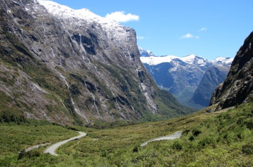
The next morning at 8 a.m. I am picked up for a day trip to the Blue Mountains. The group of eight consists of a couple from Perth, a couple from the United States, a young couple from the United Kingdom and a Japanese girl (plus me of course). It is a 2.5 hour drive to the Blue Mountain National Park, partly because it takes quite some time to get out of Sydney – it’s morning rush hour. The name Blue Mountains is a bit misleading, because the area is actually a plateau (at about 1,000 meters) where valleys have been eroded over millions of years by erosion. The area with ancient forests between steep granite mountain walls is on the UNESCO World Heritage List.

There are various viewpoints in Blue Mountain National Park (you best have wheels to drive to them). We stop at Flat Rock and Echo Point, among others. At the latter you look out over a vast green valley and the most famous rock formation in the Blue Mountains: the Three Sisters. After we stop for lunch in the town of Katoomba, part of the group goes on a cable car ride, the British couple, the Japanese girl and I choose to walk to the bottom of the valley. Via a series of (steep) stairs and paths you walk into the valley, through the rainforest, past waterfalls and overhanging rocks. In some parts the tree crickets make a hell of a noise. Down is one thing, but the only way out of the valley is back up the same way. And that is a strenuous climb. The walk takes us two hours in total, but it is very worthwhile. Before driving back to Sydney, we have tea at our guide’s house – not knowing yet that the whole area will be evacuated a few days later due to forest fires.
Sydney
When I am having my breakfast and coffee at Railway Square the next morning, the sun is already high in the sky. After taking the train to Circular Quay, I buy a ticket for the ferry to Manly. Manly is one of the suburbs of Sydney, on the north side of Sydney Harbor (officially Port Jackson). From the water you have a fantastic view of the Sydney skyline, the Harbor Bridge and the Opera House. I’m a huge fan of view of the Manhattan skyline from the Brooklyn boardwalk in New York City, and this view comes close. The ferry crosses Sydney Harbor to Manly in half an hour. From the water you can really see just how fantastic Sydney is located, on both sides of a natural harbour, an eleven kilometer long cove on the ocean coast, with steep rocks and green coves with small beaches. Much of the coastline is now built up with houses and apartments for those who can afford to live here.
After half an hour the ferry docks in Manly. Via the neatly raked (and car-free) shopping street you can walk to Manly Beach in a few minutes, together with Bondi one of the most famous beaches in Sydney. It is a beautiful, circular beach on a bay. From here you can also take walks in the Sydney Harbor National Park, but due to the high temperature (it is 33 degrees today) the parks are closed to visitors to prevent forest fires. In the summer the temperature in Sydney can rise to above forty degrees and the area is regularly ravaged by forest fires, which is why the parks are closed as a precaution when temperatures are high. The walk along the bay is nevertheless worth it.

While I’m on the ferry back to Sydney, some beautiful sailing ships pass by. Two of them sails under the Dutch flag. Weird to see the flag of your own country on the other side of the world. After enjoying the view from Circular Quay, I walk to Darling Harbour. This part of the city was renovated a few years ago and there are now numerous restaurants and cafes along a modern boulevard. With the temperature now risen to 36 degrees, I escape the heat for a while by visiting the Sea Life Aquarium, where you can take a look at the fish and coral that you can find in the waters around Australia. The most beautiful are the basins where you walk in tunnels and where the fish and sharks swim above you. Not far from Darling Harbor is Dixon Street, the heart of Sydney’s Chinatown, where you’ll be spoiled for choice for Chinese restaurants.
Melbourne
It’s Friday morning and today is a transfer day. I take it easy, pack my bag and walk into town for coffee and breakfast. Then I take the train to the airport. I am flying from Sydney to Melbourne this afternoon. It is a short one and a half hour flight to the capital of the state of Victoria. From the airport, the Skybus takes me to the center of the city, where I am dropped off in front of my hotel. Here in Melbourne, too, there is an abundance of restaurants, including the Fitzroy district, a ten-minute walk from my hotel. Australian cities are known for their dining out culture. People often eat out here several times a week. Hence the abundance of restaurants.

Calling Melbourne the San Francisco of Australia might be going a bit far, but the two cities do have something in common. They are both built on hills (although the ones in San Francisco are a lot steeper). Trams run in both cities. And both cities have an almost European appearance. Melbourne does not have the cosmopolitan look of Sydney and also not ‘eye-catchers’ like its competitor, but it is a very nice and relaxed city. One that you should leisurely stroll in. When I walk into town from my hotel on this Saturday morning, it is still chilly in the shadow of the high-rise buildings. During the day, however, the temperature will rise above thirty degrees. Melbourne’s shopping district is centered around the pedestrianized Bourke Street Mall. Old, nineteenth century buildings are interspersed with modern high-rise buildings. Here you will also find a number of covered shopping arcades: the Royal Arcade from 1869, with its black and white checkered floor, and the Block Arcade from 1891, with a beautiful mosaic floor.
I walk past the classic Town Hall down City Square to Flinders Street. If there’s one place where classic and modern architecture come together, it’s here. On one side of the street is the nineteenth century St. Paul’s Cathedral, on the other at the corner Flinders Street Station, a striking yellow-brown building from the early 1900s, where departure times of the trains are still displayed by a row of old-fashioned clocks. And across the street from this is Federation Square, the square created in 2002 that houses the ultra-modern buildings of the NGV Victoria Museum and the Center for the Moving Image. Federation Square is a popular meeting place for Melbourne residents.
South of Federation Square is the Yarra River. As you walk along the north bank across Federation Wharf, you feel like you’ve entered a different part of the city. A peaceful park with trees along the water, the Princess Bridge and the city skyline in the background. Until recently, the south bank of the Yarra River was a derelict industrial area that no one visited. Completely redesigned in the 1990s, the area is now a pleasant area, including Southgate, a modern shopping center with numerous cafes and restaurants, with terraces overlooking the river and the city’s skyline. On this sunny Saturday afternoon it is pleasantly busy with people walking along the river, relaxing on a bench under the trees or having lunch on one of the terraces.

Crossing the river is the Sandridge Bridge, an old railway bridge converted into a pedestrian bridge with striking metal artwork. Glass panels on one side of the bridge show the numbers of immigrants and descendants of immigrants living in Australia in 2001 by country, including where they came from, the reasons they came to Australia and the languages they spoke. On the glass plate about the Netherlands I read that in 2001 more than 83,000 Australians of Dutch descent lived there and more than 268,000 Australians with Dutch ancestors.
Dutch explorers, who ‘discovered’ the Australian continent and called it New Holland in the early seventeenth century, are the first Europeans documented to have visited the continent. It cannot be ruled out that Portuguese or Spanish navigators have already visited the coasts of Australia and there seem to be indications that Chinese and perhaps Indonesian fishermen already knew the continent before the Europeans arrived. However, none of the European countries saw much benefit in the new land, which was dry and warm. It was not until 1770 that the British claimed Australia as their property and established their colony at Sydney Cove. The British stayed along the coast for a long time, and it wasn’t until the mid-nineteenth century that they started exploring inland. The first expeditions to the ‘outback’ confirmed their suspicions: the interior proved dry, warm and barren. 80% of Australians still live in urbanized areas along the coast.
In the afternoon I walk back. On the north side of the Central Business District are the Carlton Gardens, a green park with the imposing Royal Exhibition Building on the north side, built in 1880 for the World’s Fair. The park is a great place to lie in the sun (or under a tree in the shade), read or have a picnic.
Great Ocean Road
On Sunday morning. I pack my things again, it’s time to leave Melbourne. I have rented a car for the next ten days. The rental company is close to my hotel, so I only have to walk a short distance and soon I’m driving down the streets of Melbourne in a cute blue Nissan Micra. Luckily, I am still used to driving on the left from my trip in South Africa six months ago. Leaving Melbourne is not that difficult: a few straight streets and then onto the M1/Princess Freeway. In contrast to the beautiful weather of the past few days, it is cloudy today and it does not take long before the first raindrops appear on the windscreen. As I get to the coast, the clouds will break open now and then, but it will remain changeable throughout the day with regular rain.

Today I am going to drive the first part of the Great Ocean Road, the coastal road that runs from Torquai to Warrnambool along the south coast of Australia. The 285-kilometer Great Ocean Road was built between 1919 and 1932 by World War II veterans and people who had lost their jobs as a result of the Great Depression. The road is a memorial to the Australians who fell during World War II. When I stop at the town of Anglesea to get coffee and a sandwich, I see the first kangaroos. A group is grazing on a lawn along the road. To see these animals in the wild you have to go to Australia, because nowhere else in the world do they live in the wild. So very cool to see!
The Great Ocean Road winds along the rocky coast, with the ocean on the left and the lush green hills of Great Otway National Park on the right. Here and there are small villages such as Aireys Inlet and Lorne and small beaches at the bottom of the rocks. Along the way you come across many parking spaces at spots with beautiful views. It’s a terrific route. The Pacific Coast Highway (Route 1) in California was an example for the Great Ocean Road. I drove that road in 2005 and I think it’s one of the most beautiful coastal roads in the world. And I have to say: the Great Ocean Road comes pretty close.

From Apollo Bay, the road winds inland through the forests of Great Otway National Park. I turn off at the Cape Otway exit. The road leads past eucalyptus trees, a great place to stop as koalas are everywhere in the trees. Some sleep, others eat, and they are not very shy. They are probably used to the prying eyes of humans. They look cute, with their fluffy fur and funny faces. A little further, in the middle of nowhere, is Bimbi Park, where I spend the night in a kind of mobile home. It is cold (only thirteen degrees), there is a strong wind and it is rainy. Not really weather to go out again.
After being cold all night, the weather seems to be getting a little better the next morning: showers and sun will continue to alternate throughout the day, but luckily the sun is getting the upper hand. The first part of the route from Cape Otway, after a short delay due to a fallen tree, is through an area of rolling hills. From Princetown I am back at the coast. Between Moonlight Head and Port Fairy, the coast is nicknamed the Shipwreck Coast. Some 700 ships are said to have sunk here over the years. Of which only 200 have been found.

The highlight of the Great Ocean Road is the section at the Twelve Apostles. Erosion has formed rock formations that stand in the ocean like statues in front of the steep coast. Initially there were twelve, but due to the ongoing erosion there are now eight left. There is a strong wind, but the sun has come through, shining a beautiful light on the already impressive coastline.
A few miles further on is the Loch Ard Gorge, where the water flows between two imposing cliffs. You can go down here, where you end up at a small beach. This is as photogenic a place as the Twelve Apostles. Another worthwhile stop is at London Bridge. The rock that jutted out into the ocean here had two natural arches through which the water flowed. However, a few years ago the first arch collapsed, so that the part with the second arch now stands seperated in the water.

Just past Warrnambool I turn right. I leave the coast and drive straight north. The road leads past endless meadows on green, gently rolling hills. It looks like Ireland. There is virtually no traffic on the road; On average I count one other car every ten kilometers. After the town of Hamilton, the mountains of the Grampians loom up. They stand out in the otherwise flat landscape. I stop in the town of Dunkeld. The friendly man at the Visitors Center gives me a map and tells me all about the beautiful routes and viewpoints in Grampians National Park, my next destination.
Grampians National Park
I am entering Grampians National Park from the south. From there, the Grampians Road leads north down a thickly vegetated valley for about 40 miles. I take the turn to drive up Mount William via a dirt road, where you have beautiful views. A little further is Lake Bellfield, where the tops of (dead) trees protrude above the water. A weird sight. I’m staying in the small town of Halls Gap tonight. The village is beautifully situated, in the midst of the mountains of the Grampians.

The next day I go out to explore Grampians National Park. After a cup of coffee I drive into the mountains via the Mount Victory Road. My first stop is at MacKenzie Falls. There is a path that leads to a viewpoint where you can see the waterfall from above, but of course it’s more beautiful to see a waterfall from below and that is what the other path is for. It is a beautiful, wide waterfall, beautifully situated in the middle of a gorge and there are very few people. Next I go to Reid’s Lookout. After a short walk (about a kilometer) you arrive at a lookout point with an amazing view over the wide valley. To your left are two rocky outcrops called The Balconies, the most photographed spot in the Grampians. The rocks are also known as the Jaws of Death because they resemble the mouth of a predator.
I drive back down Mount Victory Road to a place called Wonderland. From here you can walk a 2.2 kilometer route that ends at a cliff called The Pinnacle. 2.2 kilometers is not that far, but it is not an easy path: you walk and climb over the rocks all the way. Here and there small yellow arrows indicate which way to go. The first part you walk / climb down a gorge, which is very beautiful, with high, gray rocks on both sides, but for which the name Grand Canyon is a bit exaggerated. You get higher and higher (you bridge a height difference of 280 meters) and after the quite steep climb you come to one of the highest points of the Grampians: The Pinnacle, a cliff where the rocks go straight down, into the depths, and where you have an amazing view. No idea how far you can see, but it is far.

After enjoying the view for a while and recovering my breath, I walk back down the same way (there’s no other option). Back at Halls Gap I have some time to relax outside in the sun. Kangaroos are hopping around me. As long as I sit still, they dare to come very close.
From Grampians to Kangaroo Island
The next morning I leave Halls Gap early. I leave Grampians National Park behing me and head northwest on the Western Highway. I have a long drive ahead of me today: 580 kilometers with Kangaroo Island as the final destination. The highway (just a two-lane road where you are allowed to go 100 km/h) goes through slightly sloping landscape with the occasional small town. So nothing special. Just before Bordertown is the border between the states of Victoria and South Australia. The Western Highway becomes Dukes Highway here and I enter a different time zone: the clock is turned backwards half an hour.

You are not allowed to take vegetables, fruit and other fresh products from one state to another and there are heavy fines for violations. I still have an apple in the car and eat it quickly, but I don’t see any checkpoimt. All along the road there are signs warning against fatigue. Given the great distances in Australia, that is probably not a superfluous message. I come across signs with texts like: “Stay alert, stay alive!”, “Stop. revive. Survive” and the alarming “Weary drivers die!”. Just so you know. Fortunately, there is a ‘Powernap Area’ every few kilometers. Useful.
After driving for hours in the rather dull landscape and crossing the river at Wellington with a ferry, I am on the Fleurieu Peninsula. Here even more rolling green hills, now and then some cows or sheep and here and there a vineyard. A beautiful setting, a bit of a mix between Ireland and northern France (and for that I flew to the other side of the earth…). I’ve booked the (expensive) ferry to Kangaroo Island at 6:00 p.m., but I’ve already made it to Cape Jervis, where the ferry departs, early and I can get on the 4:00 p.m. boat. The crossing takes 45 minutes and it is advisable to hold on to something permanently, because the crossing usually does not go smoothly. The boat arrives at the village of Penneshaw, on the east side of the island. This is also where my hostel for tonight is.
Kangaroo Island
Kangaroo Island is the third largest island in Australia (after Tasmania and Melville Island near Darwin), about 150 kilometers long and about 50 kilometers wide. After climbing up Prospect Hill (for the view, also an early workout), I drive the two-lane South Coast Road to the other side of the island. Flinders Chase National Park is located here. Because of the distances, just like in Grampians National Park, you drive by car through the park to the places you wish to visit. My first stop is Cape de Couedic. The first reason to go here is the Remarkable Rocks. A more appropriate name cannot be imagined. On top of a cliff on the ocean are bizarrely eroded rocks. It looks like they were put there. Some are meters high. It is a beautiful and very photogenic place.

The second reason to go to Cape de Couedic is Admirals Arch. This is the extreme point of the cape and there is therefore a strong wind. The waves crash against the shore. On the tip is a lighthouse (a classic white-red one) and at the bottom of the cliff, on the rocks, are New Zealand fur seals. While the raging ocean beats against the rocks just a few meters away, the seals lie in peace in the sun. You can walk all the way down and there you will find Admirals Arch, a kind of big hole in the rocks, which acts as a kind of frame for the waves hitting the coast on the other side. This is very photogenicly done by Mother Nature.
On a dirt road I drive to Snake Lagoon, where you can walk a short trail (which I think is a bit disappointing). At the end of the afternoon I arrive at Flinders Chase Farm, where I’ll be staying in a cabin for the night. When I wake up the next morning, there is not a cloud in the sky. I leisurely drive back to the east side of Kangaroo Island via the South Coast Road. I stop at Vivonne Bay, which has a nice beach, but the wind is so strong that you don’t want to put your towel down. Along the way I meet wallabies, a kind of small kangaroos. They are so fast that I can’t really get a good picture of them. Incidentally, there are dead kangaroos along the road. These are often killed in the evening, when they are on the side of the road or want to cross the road and motorists cannot see them in the dark. It is said that in Australia you see more dead kangaroos than live ones…

Near Seal Bay I stop for coffee. When the lady who serves me hears that I’m from the Netherlands, she calls her husband, who is also Dutch. We chat, compare the small and densely populated Netherlands with the sparsely populated and vast Australia and I learn that there are 900 species of eucalyptus trees, of which koalas only like 12. Kingscote is the largest village on Kangaroo Island, but large is very relative. The village is located on a bay, where I find a deserted beach to have lunch. It’s nice and quiet. The peace is only disturbed by flies. There are some very annoying flies here in Australia. They are smaller than the flies back home, but with the annoying habit of always wanting to sit on your face. Not on your arm or leg or anywhere else, just on your face. And slapping away doesn’t help because they are very persistent. They are all over Australia and they are super annoying!
Barossa Valley
After waking up the next morning to the loud twittering of the birds, I am back on the ferry, which takes me back to the mainland (Australia itself being an island of course…). The news is about the 40th anniversary of the Sydney Opera House and the forest fires in the Blue Mountains. The fires broke out right after I visited the Blue Mountains myself last week and they are the worst fires in a decade, according to the news reports. After 45 minutes I am back at Cape Jervis.

My destination for today is the Barossa Valley and the end point Clare. For that I have to go around Adelaide first. Well, there’s no getting around it: I have to go straight through the suburbs. It is very busy and it takes me a lot of time to get past Adelaide. I keep hoping to see a sign saying ‘Barossa Valley’, ‘Sturt Highway’ or ‘North Road’, which would all be in the right direction, but no. I’m on the ‘South Road’ for a long time, ignoring all the exits towards ‘Port Adelaide’ (the harbour) and ‘City’, because I don’t want to end up in the center of the city. For a long time I have no idea where exactly I am and whether I am going in the right direction (especially at the diversion due to road works). But after a while it turns out I’m actually on the right track and eventually I turn onto the sought-after North Road.
More suburbs follow, but after a while they give way to a hilly landscape. The Barossa Valley roughly begins at the town of Gawler, an hour’s drive from Adelaide. From Mengler Hill you have a panoramic view over the wide valley, full of vineyards. From the mid-nineteenth century Lutherans from Germany (fleeing persecution) settled here and until the Second World War mainly German was spoken in this area. In the village of Tanunda you will still find the old wooden buildings from the nineteenth century along the main street.

In 1847 the first winery was established at Rowland Flat: the Orlando Winery, where Jacob’s Creek wines, also available in the Netherlands, are produced. Today, the Barossa Valley is home to some sixty wineries, ranging from small family businesses to major brands such as Jacob’s Creek, Penfolds and Wolf Blass. The latter are actually more factories than wineries, with large production buildings and huge stainless steel barrels. The Jacob’s Creek Visitor Center in Rowland Flat is commercial and anonymous, and the information is sparse. You can taste wine there, but since I still have to drive, I have to skip that.
I continue past the villages of Nuriootpa and Kapunda, where, as in Tanunda, the wooden buildings make it look like nothing has changed since the 1800s, and then north to Clare Valley. The two-lane road leads through endless green hills under a radiant blue sky. After the Barossa Valley, the vineyards give way to grassland for a while, but in the Clare Valley the vineyards dominate again. At 4 p.m. I arrive in Clare, a small town, where I will spend the night at the Clare Hotel. The term ‘hotel’ is a bit confusing. In Australia, a ‘hotel’ is usually a cafe/pub, sometimes a real hotel and often a combination of the two (a cafe with a few rooms). The Clare Hotel belongs to the latter category. Downstairs is a pub, which has horse races on TV, slot machines and lotto tickets on the table; Australians love gambling.
Flinders Ranges
The next morning I leave Clare and head for the Flinders Ranges, about 300 kilometers to the north. My intention is to drive through Hawker, but when the asphalt road becomes a dirt road and road signs a rarity, I wonder if I am driving in the right direction. After a while at an intersection I see a man with a pickup on the roadside and stop to ask if this is still the road to Hawker. Yes and no. Apparently I missed a turn somewhere, but I’m not completely out of the way. The man advises me to turn left and then past Jamestown take the road to Hawker. The advice is accurate and not much later I see the traffic signs I was looking for.

The landscape changes: the greenery of the vineyards has given way to low vegetation and the earth turns reddish brown. The temperature is rising, the landscape is becoming visibly drier, the distance between farms is increasing and car radio reception is getting weaker. I drive into the ‘outback’, the dry interior of Australia. Here and there dead kangaroos lie along the road and (live) emu’s are grazing. Otherwise nothing but dry landscape with some low vegetation and the mountains of the Flinders Ranges looming in the distance.
Hawker turns out to be just a small town, in the middle of nowhere, but big enough to have a gas station (which I gratefully use) and a cafe to get coffee. After Hawker, it’s not far to Rawnsley Park Station, on the edge of the Flinders Ranges, where I’ll be staying in a cabin tonight. Fortunately, that cabin has a pent under which you sit in the shade and where now and then some wind blows, because it is 46 degrees in the sun and 37 in the shade… The birds are clearly not bothered by that: blue with green Ringneck Parrots and gray and pink Galahs are constantly flying around.

Monday morning. Today I visit Flinders Ranges National Park. This is an area of about sixty by forty kilometers, with Wilpena Pound on the south side, a large plateau, surrounded by a ridge of reddish-brown rock, which towers high above the largely flat area. It will be a day of vistas. The mountains and valleys of the Flinders Ranges are millions of years old. I make a kind of loop to visit most of the National Park. Via Stokes Hill (viewpoint) and the Appealinna Ruins (of nineteenth century settlers) I drive north. Coniferous slopes alternate with almost barren plains. Kangaroos and emu walk here and there.
From the town of Blinman I take the dirt road down the Parachilna Gorge. For thirty kilometers I bump down the gorge and over (mostly dry) riverbeds. The also unpaved road down the Brachina gorge turns out to be even worse (but fortunately doable with a ‘normal’ car. The only oncoming car I encounter is a 4×4). After the Bunyero Gorge you drive over the mountains again, with beautiful views along the way. It is spring and blue and white flowers are blooming everywhere. At the end of the beautiful tour I drove almost 200 kilometers.

Adelaide
When I leave the Flinders Ranges it is raining and the sky is covered by a thick gray cloud cover. Today the long drive back to Adelaide is on the agenda. There is not much to tell about that drive: endless plains, slightly sloping, sometimes nothing, sometimes grass and later mainly gold-colored wheat fields. The only interruption is a stop to buy coffee and a sandwich. When I drive into Adelaide in the afternoon, I do follow the ‘City’ signs this time. Adelaide city center has a simple street plan with straight streets, but many of them are one-way streets and you have to watch out for the trams. I hand in my rental car (I drove almost 2,900 kilometers in ten days) and walk to my hostel, which is one block away. I have to wait a long time until someone finally shows up and then it turns out my room is not ready yet. So I go for coffee first.
I won’t beat around the bush: Adelaide is not a pretty city. The straight streets are dominated by large buildings made of concrete, steel and glass, often in shades of gray. In between, the old Victorian buildings resemble lost tourists. Maybe it’s also because it’s cloudy, there’s a strong wind and the occasional drizzle, but in my opinion the city has no atmosphere, and in that sense it is very different from Sydney or Melbourne. Along the North Terrace are some fine University of Adelaide buildings and some museums, but the street itself is a busy thoroughfare. And it seems that they are building (re)building everywhere: the central Victoria Square is broken up, the Rundle Mall shopping area is being resurfaced and the cricket stadium is also being renovated.
On the north side of the center runs the Torrence River, along which a park has been laid out, but the image of an urban oasis in the middle of green parks sketched in my travel guide: I don’t see it. I walk a bit about the city, down the shopping street (convenient: the food courts in the shopping centers) and past the Central Market, a covered market hall, where you can buy fruit and vegetables as well as souvenirs and next to it the (small) Chinatown with its associated restaurants.
From Adelaide to Yulara
It is only a short taxi ride to the airport and once there I am surprised to discover that the airport is still closed. Adelaide is not a small city at all, but apparently the airport here closes at night… I’m flying this morning with a layover in Sydney (which is quite a detour) to Yulara, also known as Ayers Rock Airport. During this domestic transef I will be hopping from one time zone to another and back: In Sydney (New South Wales) it is half an hour later than in Adelaide (South Australia). In Yulara (Northern Territory) it is half an hour earlier, just like in South Australia, but there they do not have daylight saving time (as in New South Wales and South Australia), so in Yulara it is an hour and a half earlier. I have to admit that at a certain point I didn’t know what time it was anymore…

To get to Yulara you fly over the dry interior of Australia: the ‘outback’. It’s clear, so if you’re sitting at a window you have a great view – even if there’s ‘nothing’ to see. The Northern Territory covers one fifth of the surface of Australia, but only one percent of the population lives there. Endless rusty brown plain: the reason why the outback is also called ‘the red center’. There is a reason that the ‘red center’ is red. The sand and rocks are sandstone and actually gray, but the stone contains a lot of iron and iron rust. So the outback is reddish brown due to oxidation. The landscape is not completely flat and despite the drought it sometimes rains here and that has resulted in dark lines worn out by rainwater everywhere. There is no water to be seen, but from the air you can see beautifully where it has run and left motifs in the landscape, like meandering rivers or branches of trees.
Every now and then you see a dead straight line running through the landscape: a dirt road, which leads kilometer after kilometer through barren, dry and inhospitable landscape. In the summer the temperature here can rise above fifty degrees. In the middle of the ‘red center’ are two places that are considered sacred by the Aboriginals: Kata Tjuta (formerly: The Olgas) and of course: Uluru (formerly: Ayers Rock). The first time I see Uluru is from the air: A huge reddish-brown monolith in the middle of an otherwise flat environment. What is immediately noticeable: it is not at all such an evenly shaped smooth rock as it appears on the postcards and photos on the internet. Uluru, on the other hand, is erratic and there are holes and fissures in the rock everywhere.
Ayers Rock Airport is small, with one runway and one baggage claim. To my dismay I discover that my luggage did not come with me. The airline lady is extremely friendly and helpful and soon discovers that my backpack is still in Sydney. It will be sent on the next flight tomorrow. Next am picked up from the airport, together with a couple of other people, by Adventure Tours. I booked an organized 3-day tour with them. The rest of the group of 24 people is already at the campsite in Yulara, they arrived this morning from Alice Springs. Almost all of Western Europe is represented: Germany, France, Belgium, Italy, Ireland, Denmark and the Netherlands (me). There is also a number of Japanese and a Korean. Tonight we sleep in (permanent) tents. I expected to share a tent, but it turns out I have one for myself.
Kata Tjuta and Uluru
After lunch we go to Kata Tjuta. The name means ‘many heads’ in the language of the Anagnu, the Aboriginal people who are said to have lived here 20,000 years ago. The reason they came here (from other parts of the outback) was the water sources. In this hot and dry area, water sources were vital, both for the people themselves and for the animals that came to the springs and provided meat. Only a small part of Kata Tjuta is open, the Aboriginals keep the rest to themselves because according to them it is a holy place. The mountains of Kata Tjuta (as mentioned actually grey, but colored reddish brown by oxidation) are higher than Uluru, but they are several mountains and not a monolith. It may have once been a monolith, but it has eroded to such an extent that several mountains have been formed.

The first Aboriginal people probably lived on the Australian continent about 400,000 years ago. Way before the Europeans and yet the history of Australia is the history of the European settlers and the development Australia has gone through since then. Before the settlers arrived, Australia is estimated to have been home to about 300,000 Aboriginal people. That number has been decimated, both by disease and by murder. Their culture is the oldest surviving culture in the world, but Aboriginal people were not seen as humans by Europeans, but as ‘subhumans’, a lower species. Settlers were allowed to kill Aboriginal people with impunity (which they regularly did). The Europeans expelled the Aboriginal people from their land and the struggle over the rights of the current and former landowners continues to this day.
Until well into the twentieth century, Aboriginal people had no rights at all. They were not considered Australian citizens and were not counted in censuses. Aboriginal people try to claim rights to their original land through legal means. With limited success, though the Australian government has now recognized the Aboriginal people as the original inhabitants of the country. Something similar happened to the original people in the United States, but at least there has been a lot of debate about those events since then and it has become a part of American history. In Australia, this piece of the past still seems to be a big taboo. In many Australian history books, the Aboriginal people are barely mentioned, or not at all.

We walk for two hours down the Valley of the Winds, past and between the mountains. Then we go to Uluru to see the sunset. That sounds very romantic, but it is not: there are dozens of tourists who also come for the sunset. Uluru is the most visited place in Australia and has been a UNESCO World Heritage Site since 1987. The rock was first discovered by a European in 1872 and named after then Prime Minister Ayer of South Australia a year later. With the arrival of the Europeans, the removal of the Aboriginal people from the area began. In 1985 the judge ruled that the Aboriginal property claim as original inhabitants of the area was justified and now the area is officially their property again. But with the establishment of the National Park, the area has been leased back to the Australian government and the National Park is now jointly managed. Uluru turns a beautiful deep red when the sun sets. It’s great to see the world famous rock in person, but to be honest it’s less impressive than I expected.
The next morning we have to get up at 4 a.m.. I slept well, but I’m still sleepy at breakfast. After breakfast we are taken back to Uluru by bus. The rock has a size of six kilometers and the walk around it is about ten kilometers. The sun slowly rises during the walk around Uluru. Everyone walks at their own pace, so the group quickly disintegrates. The walk takes me two hours. Next, as if we haven’t walked enough, we set out for another hour and a half with an Aboriginal guide. We pass places we haven’t seen before, such as the caves where Aboriginal people stayed and places where rock carvings can be seen, but otherwise I think it’s not very interesting.

After lunch, part of the group leaves the tour and at the airport I check whether my luggage is there, which turns out not to be the case. The plane is still in Sydney due to ‘technical problems’. The problem is that we leave for King’s Canyon this afternoon, which is a four-hour drive from Yulara. It is agreed that my luggage will be sent directly to Alice Springs, where I can collect it tomorrow afternoon. Since the airline does not fly to Alice Springs, they will transfer my backpack to another carrier. Hopefully that will work… I already have to wear the same clothes another day…
Kings Canyon
Via the Stuart Highway, the paved road that runs right through the outback from the south of Australia to the north, we drive north. We stop on the way at Mount Connor, a flattened mountain (mesa), where there is also a salt lake. In the outback are several salt lakes, a remnant of the great inland sea that was here millions of years ago. At the end of the afternoon we arrive at the campsite in Watarrka National Park, where we will visit the Kings Canyon tomorrow.

Again we have to get up early and unfortunately I didn’t sleep as well this time (although I had a tent to myself again). We are going to do the rim walk, a six kilometer walk along the rim of Kings Canyon. It’s not that warm when we start, but the rim walk starts with a steep climb to the rim of the gorge. During the walk the temperature will rise to well above thirty degrees. It is a brisk walk, constantly on uneven ground, but very beautiful. One moment you are walking between the reddish-brown rock walls, the next you have a view over the gorge.
Halfway through you can go down into the narrow gorge. On the bottom it is cool and – thanks to a water source – green, which is why it is called the Garden of Eden. The water source is a beautiful place, between the steeply rising rock walls. The rim walk goes around one side of the gorge and back along the other side and it takes us about 3.5 hours. Then the long drive to Alice Springs begins. I can pick up my backpack there this afternoon. We are just in time, because the airport closes at 5 p.m., but within five minutes I have my luggage back. Happy! Finally I can put on some clean clothes again.

Alice Springs and Atherton Tablelands
Alice Springs is located right in the geographic center of Australia. The Aboriginal people have been living in the vicinity of the MacDonnell Ranges for millennia, an area with mountains, valleys and water sources, just outside present-day Alice Springs. The town is the result of John McDouall Stuart’s explorations. He led an expedition that was the first to cross the Australian continent from north to south, laying the foundations for the north-south link that is now the Stuart Highway. However, the first connection was not a road, but the Overland Telegraph Line, which was built in 1870. This telegraph link connected to the link between Darwin and Indonesia, enabling communication between the British colonies in the south and east of Australia and the rest of the world. A telegraph station had to be built every 250 kilometers and the station at a water source near the MacDonnell Ranges was the beginning of present-day Alice Springs (which was initially called Stuart Town, but the telegraph company’s boss managed to name the town after his wife, Alice).

It’s Sunday morning and I’m having a relaxed day in Alice Springs. I walk into town, along the Todd River (which is almost always dry) to Anzac Hill. From this hill on the north side of the compact center you have beautiful views over Alice Springs and the mountains of the MacDonnell Ranges. In Todd Mall, the shopping street, a market is going on and it is pleasantly busy. The sun is high in a cloudless sky and with 36 degrees it is nice and warm. After a cup of coffee I go to the Reptile Center. Not only is it cool there, but they also have a large collection of snakes, lizards and other reptiles that you encounter in Australia. Also some that you would rather not encounter in real life, such as the extremely poisonous Taipan. The Reptile Center is a good place to see them. Back at my hostel the temperature has risen to 43 degrees, too hot to really do anything active. Instead, I book a tour to the Great Barrier Reef online for when I’m in Cairns. After some comparative research I choose Seastar Cruises. At 3:30 p.m. I am picked up and taken to the airport for my flight to Cairns. My last destination of this trip.
It’s only an hour’s flight from Alice Springs to Cairns, but the difference is big: from the dry outback to tropical Cairns. With 31 degrees it is less warm on paper, but it is a humid, clammy heat. The next morning I pick up the car I have rented for the day to go to the Atherton Tablelands. This is a mountainous area to the (south)west of Cairns. This entire area was once covered with tropical rainforest, but mining (tin) and logging have ensured that most of it has disappeared. In its place are now grassy hills and a single farm. But blink your eyes twice and you’re back in a piece of tropical rainforest.

Via the town of Gordonvale I first cross the Gilles Range via a winding road. Volcanic activity in the soil has created crater lakes in a number of places in this area, such as Mobo Crater (a small pool surrounded by tropical rainforest) and Lake Barrine (a larger lake). I will also take a look at the Cathedral Fig Tree, a huge, fifty meter high fig tree in an area with tropical rainforest. After stopping for lunch in the small village of Yungaburra, I drive south via Malanda. Three beautiful waterfalls are located here in a part of the tropical rainforest: Millaa Millaa, Zillie and Elinjaa. It is quite a strange experience to suddenly walk here in the tropical rainforest after the rest of Australia. It’s so green here and the vegetation is so different, with palms and ferns instead of Eucalyptus trees.
Great Barrier Reef
I know of no better way to spend my last day in Australia than with a visit to the Great Barrier Reef. The Great Barrier Reef is the largest coral reef in the world. The reef (consisting of several separate sections) covers an area of 2,300 kilometers in length, from the northernmost tip of Australia (Cape York Peninsula) to beyond Mackay along the east coast of the continent. The reef follows the boundary of the continental plate of which Australia is part and is formed by one living organism: coral. The Great Barrier Reef is a UNESCO World Heritage Site, but it has suffered greatly from environmental changes, pollution and tourism.

At 7:30 a.m. I report to pier E of the marina in Cairns, where the catamaran Seastar is already waiting. Among the super nice international crew of the Seastar is a Dutchman: Jelle, who is called ‘jelly’ by his colleagues. The approximately thirty guests on board also come from different countries. Once we’re underway, I sit on the foredeck, where you have to accept the occasional shower. The weather is beautiful and according to the crew the temperature of the ocean water is no less than 27 degrees.
In an hour we sail to our first stop: Michaelmas Cay. This is a very small island, made up only of white sand, and home to a colony of birds. It is the first place where we go snorkeling. It has been twelve years since I learned to snorkel and that was not in the open water of an ocean, so it takes some getting used to at first. I first follow the ‘snorkel tour’, where a guy named Vinny shows us around and explains and points out fish. Afterwards we have plenty of time to swim around freely. In the shallows around Michaelmas Cay, the coral is close to the water’s surface. Also above water you can see through the clear water where the coral is and how close it is to the surface. It’s really beautiful!
The underwater world is so different from our ‘own’ world above water. Everywhere you see different types of coral: soft coral that moves with the current, spherical coral, and different colors: brown and gray, but also yellow and blue. And fish everywhere in all shapes and sizes and colors. I’ve been to the SeaLife Aquarium in Sydney, where you can see a lot of what you see here, but that doesn’t compare to the real coral reef, where you swim in the midst of it. I keep swimming in circles, it just doesn’t get boring.

Back on board we are served an extensive lunch. Not bad at all: have lunch in your swimming trunks in the sun on the foredeck of a catamaran. After lunch we go to Hastings Reef. Here we snorkel from the boat. The coral reef here is very different. In some places it sits just below the surface of the water, before diving into the depths, like a kind of underwater cliffs. This part of the reef is also very beautiful and there are many fish here too. We are 2.5 hours in both places, so we really have all the time to enjoy the natural beauty. The visit to the Great Barrier Reef is an unforgettable experience and a amazing final day of my trip to Australia!
Back to the Netherlands
The next day, Wednesday 30 October, I pack my things and take a shuttle bus to Cairns airport. I have another long journey ahead of me: first to Hong Kong in just under seven hours, waiting there for six hours and then another twelve hours back to the Netherlands. It will be 6:30 on Thursday morning when I get there. Along the way I can reminisce about an amazing journey. 3.5 weeks is of course not enough to see all of Australia, so I had to make choices. But they have been good choices, a combination of cities and nature, from the cool south coast to the warm interior and the tropical north. If I had to choose, Sydney, Melbourne, the Great Ocean Road, Kangaroo Island, Uluru and the Great Barrier Reef were the highlights. I have seen a lot in 3.5 weeks, but I will have to come back to see the rest of Australia, because there is much more!


You May Also Like