California, USA
Itinerary: Los Angeles – Pacific Coast Highway (Route 1) – Yosemite National Park – San Francisco
Los Angeles
After a long, fourteen hour flight, including a transfer in Paris, I arrive at Los Angeles International Airport for a two-week road trip in the state of California. It takes only fifteen minutes to go through customs and security. At the rental car company, a gold-coloured Ford Focus (US edition) is waiting. The way to Venice Beach (the coastal district of LA where my hostel is located) is not difficult, but once in Venice it is a bit of a search for the Cadillac Hotel. Narrow streets and lots of one-way traffic. The hostel is right on the Ocean Front Walk. This is the 1.5 kilometer long promenade that runs along Venice Beach, also known as Venice Board Walk. Along the boardwalk are all shops that sell the well-known tourist knick-knacks and various cafes and eateries. On the boardwalk itself you will find a colorful collection of street vendors, musicians and palm readers, many tourists, youngsters and quirky types who populate the boardwalk every day. There is also a bicycle and skate path along the boardwalk and further on, guys are playing basketball. The beach itself is quite empty, just a few people, and all in all there is a relaxed atmosphere. The houses of the life guards known so well from the tv-series Baywatch are really cool to see. Plus the weather is sunny, so shortly after I have arrived, I’m in a holiday mood.
The next morning I drive to Hollywood. Driving is quite easy and the street names are very clearly indicated with large signs in the middle above the road. But signs that indicate where to go (turn right, left, direction this and that) are nowhere to be seen. The drive from Venice to Hollywood, which is on the other side of Los Angeles, takes almost two hours. That’s how vast Los Angeles is. First I stop by the Paramount Studios, the largest still active television and film studio in Hollywood. Today it looks like there are recordings for Dr. Phil taking place. Then I walk down Hollywood Boulevard. On either side the sidewalk here is the famous Walk of Fame, with stars with the names of famous actors, musicians, writers and so on. I walk past the Egyptian Theater (the oldest cinema in LA), El Capitan Theater, Mann’s Chinese Theater (the most famous movie theater in LA) and the Roosevelt Hotel, where in 1929 the first Academy Awards (the Oscars). I walk back via Sunset Boulevard. Not really an interesting street, why did I think that when I heard the name Sunset Boulevard? My travel guide has the answer just down the road, Sunset is known as the ‘Sunset’ Strip’, an area with many billboards and even more bars and clubs where many famous artists started their careers.
Next I go look for the Hollywood sign. You know, those big letters on that mountain. After a long search and trying and via an uphill winding street in an otherwise quite deserted residential area (with signs everywhere “no access to Hollywood sign”), I finally come pretty close to the famous letters. There is no one else to be seen here. Good thing I have a car, otherwise I would never have come here. After this short adventure I drive down Sunset towards Melrose Avenue, park my car and start walking again. Los Angeles is a sprawling city, with lots of low-rise buildings, wide roads and streets and enormously large distances. Melrose is little more than a busy road with shops, boutiques and galleries. Nice shopping for the more affluent among us, that is. The surrounding streets are leafy and lined with beautiful houses. In Beverly Hills the houses are even more beautiful. This district is like you’ve seen on tv. Wide avenues with beautiful trees, houses like castles and expensive cars in the driveways. Even the street signs are just a bit more chic here than in the rest of the city. I drive via Rodeo Drive to the famous (pink) Beverly Hills Hotel, the very expensive hotel where many celebrities have stayed. Finally, I drive past the CBS television studios and then (somewhat on a gamble) drive down Fairfax Avenue, hoping to head toward Venice. After a while I actually cross Venice Boulevard, which runs straight to Venice.
Downtown Los Angeles is the Financial District and the Civic Center to the north of it. All this is an hour and a half drive from Venice. Tall buildings of glass and concrete dominate here. For that reason (and because it is located on a hill) the Financial District is also known as ‘Bunker Hill’. Except for Bunker Hill, the rest of downtown LA is like the rest of the city: wide streets and avenues, low buildings and therefore vast. I walk up Fifth Street and Grand Avenue, past the Public Library and the new Walt Disney Music Hall, past City Hall, the LA Times building all the way to Union Station. Close to Union Station is a Mexican neighborhood, including a Mexican market, where today ‘Cinquo de Mayo’ is celebrated (on the occasion of the defeat of the French by the Mexicans, long ago). On Wilshire Boulevard I pass the dilapidated former Ambassador Hotel, where in 1965 Robert Kennedy was assassinated. Back in Beverly Hills I walk down Rodeo Drive, where all the expensive clothing brands and such are. Shopping area for the rich and famous. A little further down Wilshire Boulevard, in the Westwood district, I take a look at Westwood Memorial Park, a cemetery where Marilyn Monroe is buried.
The next day the weather is beautiful and so I take my beach gear to Santa Monica. For the first time I don’t have to drive far: Santa Monica is right next to Venice. If I had to choose, I would know: Santa Monica is a very pleasant town. Nicely decorated, clean, not too crowded, with a nice beach and without the quirky types of Venice. A slightly elevated boulevard annex park (Palisades Park) runs along the beach from where you have a beautiful view over the beach and the famous pier of Santa Monica. Unlike Dutchies, Americans don’t flock to the beach as soon as the weather is nice. The beach is therefore quite deserted. Time to relax.
Pacific Coast Highway (Route 1)
The next morning I leave LA for the first part of Highway 1, or the Pacific Coast Highway, from LA to Santa Barbara. On the way I stop for coffee in Malibu. The best surfing beaches seem to be here and indeed there are many ‘beach boys’. Highway 1 runs straight through Oxnard and from there to Santa Barbara I have to take Highway 101, because there is no Highway 1 on that part. At 11 a.m. I arrive in Santa Barbara, known for the soap opera of the same name. Santa Barbara is a friendly-looking town that was completely destroyed by an earthquake in the 1920s and then completely rebuilt. Hence the consistently implemented mission-like architectural style with all white houses with red tiled roofs. It gives Santa Barbara more of a Mediterranean feel than an American one. It’s very different from the beach towns of LA. Right behind the city rise the Santa Ynez Mountains. Stearn’s Wharf, the pier of Santa Barbara, is teeming with tourists. You will also find fishermen, seagulls and pelicans, but there’s only a few people on the beach.
After Santa Barbara, I have to drive a part of the 101 again, but after an hour I can get back on the Pacific Coast Highway. The two-lane road leads through a green hilly landscape. At Lompoc I take the exit to Highway 246, where a little further on is the mission post La Purisima Conception. This was one of the mission posts along the Camino Real. A very quiet place in a beautiful green area. After Lompoc the road continues through the hilly landscape, now with more farmland. The road is sometimes four-lane, sometimes two-lane. After an hour I pass through villages like Oceano, Grover Beach and Pismo Beach. The first two seem to consist entirely of Recreation Vehicles and Mobile Homes. Neatly arranged in neighborhoods with streets and gardens, a bizarre sight. Pismo is a very touristy seaside resort with allegedly good beaches. But I continue my way to San Luis Obispo. The mission post is here in the middle of the village (or better: the village is built around the mission post). Next to it is a park with benches in the shade and complete with a babbling brook. Furthermore, San Luis Obispo is a neat little town, just like Santa Barbara, but without the appeal of the beach.
Continuing on ‘Route 1’, I soon come to Morro Bay, a small coastal fishing village, best known for Morro Rock, a large rock just in front of the harbour, which is the result of Volcanic activity in this area. It’s quite busy with day trippers and for me only a short stopover. As I drive further the weather changes from very sunny to very cloudy. I actually wanted to go and see Hearst Castle it’s so cloudy that the ‘castle’, which is on top of a mountain, is completely covered in clouds. So it makes little sense to visit.
The Big Sur is considered the most beautiful and famous part of the Pacific Coast Highway. The first part of the route is still fairly flat. Just past San Simeon I stop for a while. The beach here is dotted with sea lions. I think there are two hundred, no exaggeration. A great sight. They make a lot of noise and also smell bad, but it’s very nice to see. A little further on, the landscape gets rougher. The mountains get higher. Here you drive right along the sometimes almost vertical rocks. The signs ‘rock sliding’ are there for a reason: there are rocks on the road in various places. I also come across signs that read: “$1000 fine for littering”. The views over the ocean are breathtaking. I get out regularly to enjoy the view and take photos. Some say the Pacific Coast Highway is the most beautiful coastal road there is and I must say, it is beautiful. Well worth it. The road seems carved out of the rocks and winds its way up and down in many curves in a northerly direction, revealing new vistas again and again. Point Sur Lighthouse and Bixby Creek Bridge are well-known and standout points on the route, but the whole route is really worth it.
Yosemite National Park
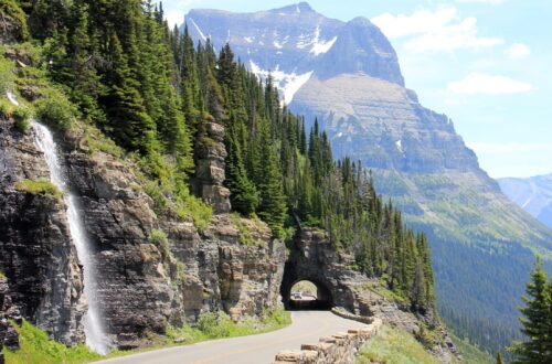
The next day I leave the Pacific Coast Highway behind me. Via Highway 152 I drive through towns like Gilroy and Los Banos towards Merced. No more coast, the road goes down the San Joaquin Valley, the lower lying part of California between the coastal ranges and the Sierra Nevada. A wide landscape with lots of farmland and some vineyards. Towards Mariposa, however, the landscape changes and becomes more mountainous. Slowly I enter the Sierra Nevada. It’s a beautiful route, right through the Sierra National Forest. After a four-hour drive on Highway 41, I arrive at the southern entrance of Yosemite, where I turn right, towards Mariposa Grove. In the Mariposa Grove there are several
so-called ‘Giant Sequoias’, huge redwoods that are the largest living organisms on Earth. There is still snow in some places in the forest, which makes for beautiful photos with the sun that comes through the trees.
After Mariposa Grove it’s still quite a drive to Yosemite Valley. Yosemite National Park is really huge, but the Yosemite Valley is the best known and most visited part. The road first goes up and then down again, until after a tunnel there is an absolutely mandatory stop, called Tunnel View. From this spot you have a breathtaking view over the valley. El Capitan, The Half Dome, Yosemite Falls, Bridaveil Fall and Cathedral Rock, you can see all the highlights of Yosemite Valley from here. Really incredibly beautiful and impressive! You read so many lyrical stories about the beauty of Yosemite and the impression that the granite formations made on the people who saw them for the first time, and when you stand here and look at it yourself, you get the same feeling. As I drive down the road through the valley, one beautiful view after another unfolds.
I’m staying at the Lower Pines Campground, where I am advised (for the umpteenth time) to remove all food et cetera from the car and to store it in the bear-proof boxes at every site. A warning that you better not ignore, after all, those bear traps along the edge of the campsite are there for a reason. I wonder if I will see any bears… After a freezing cold night I get up early and walk to Mirror Lake. It’s wonderfully quiet, I am almost alone. Mirror Lake (actually a pool in the Tanaya Creek) is incredibly beautiful. Right in front of you is the Half Dome, which reflects in the water. Then I walk west, all the way to Yosemite Falls. Along the way I come across another waterfall. And now and then some people, but it is certainly not as busy as the travel guide and magazines lead you to believe. In high season maybe and maybe it’s because I’m early in the season, but I’m walking alone pretty much all the time.
After another cold night I drive down the Big Oak Flat Road to the west exit of Yosemite National Park, on highway 120 towards San Francisco. At Valley View you have a fantastic view over the valley. A little later, according to the signs, I reach an altitude of over 6,000 feet. There is still quite a bit of snow here, a bizarre contrast with the green valley. Then I leave Yosemite National Park and drive straight through the San Joaqiun Valley again. Just before Oakland, the roads widen and traffic gets busier. I am now on Interstate 580, a five-lane freeway. I follow the Bay Bridge/San Francisco signs and when I cross the Oakland Bay Bridge, the San Francisco skyline looms on my right, including San Francisco Bay, Alcatraz Island, and the Golden Gate Bridge. A great sight!
San Francisco
The first thing I do when I drive into the city on the other end of the bridge (besides entering a one-way street from the wrong side…) is returning the car. Two blocks away is my hostel. It’s close to Union Square, the heart of downtown San Francisco. The square has been laid out in a modern way with steps and elevations, where people sit when the weather is nice. Along the square runs Powell Street, along with California Street one of the two streets where the famous cable cars run. Here you immediately notice how steep the streets are. It is the well-known image of ‘the streets of San Francisco’, the city built on hills. I walk up to California via Powell, quite a climb, and from there a bit into the Financial District. This includes the TransAmerica Pyramid, one of the iconic buildings of the San Francisco skyline. In reality it is quite an impressive building. After a few more buildings (Federal Reserve, Bank of California, all old monumental buildings) I walk back to Union Square.
The next day I walk down Market Street towards the Embarcadero Center in the heart of the Financial District. The Embarcadero Center is a modern office and retail complex and in my opinion an example of a serious lack of creativity. Just gray concrete highrises. From here I arrive at the Embarcadero, the wide boulevard that runs around the east and north sides of the city along the entire bay, from the Bay Bridge to Fisherman’s Wharf. I find myself at the Bay Bridge and decide to walk down the Embarcadero, with a view of the bay and the piers on the right and the city on the left all the way. First, however, I admire the Bay Bridge. It used to be orange (or red) just like the Golden Gate Bridge, but for some reason the bridge is now painted gray. The walk along the Embarcadero is quite long and because the sun has started to shine again, it is also quite warm. Pier 39 is mainly a tourist attraction (many shops, restaurants and the Hard Rock Café), especially the sea lions attract a lot of attention. Fisherman’s Wharf is another such tourist attraction.
Although somewhat of a challenge, I decide to continue walking, via Fort Mason and Marina towards Presidio and – eventually, the Golden Gate Bridge. A five-mile walk. Fort Mason is an old military complex, Marina a beautiful suburb. I keep walking along the bay – in Marina the piers have been replaced by marinas. From here you already have a view of the Golden Gate Bridge, which at this time (around noon) however, is still partly shrouded in clouds. In the morning the bridge is not visible at all and during the day the clouds slowly lift and the bridge appears. This part of my self-invented walking route is also an official one: the Golden Gate Promenade. At 3 p.m. I arrive at the Golden Gate Bridge itself. The last part of the walk, the clouds have completely disappeared and I have a fantastic view approaching the bridge. It is and remains by far the most beautiful bridge in the world! The Golden Gate Bridge is probably the third and last real highlight of this trip (after Big Sur and Yosemite). Very nice, I can look at it for hours. The best place to do that is Fort Point Lookout, with the bridge on the left, the bay with Alcatraz right in front of you and the city skyline on the right.
The next day I visit the Civic Center and The Haight. Civic Center is nearby and includes United Nations Square, where attention is paid to the fact that in 1945 the UN charter was signed in San Francisco. Also here is the must-see City Hall, with a gold-adorned dome that is higher than that of the Capitol in Washington. Quite a statement. Before I get to the Civic Center, I first pass a part of the Tenderloin district, which is a poorer district. Lots of black homeless people on the street. I already noticed that in San Francisco there are a lot of homeless people and beggars on the streets. Whether it’s because of the zero tolerance policy, I don’t know, but I don’t remember seeing so many homeless people and beggars in New York City. From the Civic Center I walk down Grove Street, into The Haight neighborhood. Here you will find many of those well-known Victorian-style wooden houses. My target is Alamo Square, which borders Steiner Street. From here you have a great view over the city with the famous ‘painted ladies’ in the foreground, a row of seven Victorian houses. A classic picture. I walk on via Mission Street, which runs parallel to Market Street. This is the SoMa district, or South of Market. It all looks rather desolate, there is still a lot of work to be done here. It’s only from Fourth Street that SoMa looks a bit better. The Yerna Buena Gardens (a kind of park), the Museum of Modern Art and the modern entertainment complex Metreon are located here.
It’s Sunday morning when I walk down Powell Street, which ends at Pier 41, from where the ferry to Alcatraz Island departs. Alcatraz is quite impressive. Rows of cell blocks with heavy bars and doors that can be closed centrally, the cells no larger than two by two and a half meters. Those who have been here have not had a good time. If you’ve seen the movie ‘Escape from Alcatraz’, you can imagine what it was like here. Back on the mainland I walk up Russian Hill, towards Lombard Street, the part called the ‘crookedest street in the world’. A typical tourist spot. Then I walk to North Beach, which is also called Little Italy. The Italian quarter. You can tell when you get there by the Italian flags painted on the lampposts. And Columbus Avenue is called Corso Christophoro Colombo here. Lots of Italian eateries too.
After another relaxing day in San Francisco my trip to California is over. It was a great trip, the Pacific Coast Highway and Yosemite National Park were incredible and I had a good time in San Francisco. I will probably come back one day.